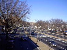
- Woodhaven Boulevard
-
Woodhaven Boulevard is a major boulevard that runs roughly north–south in the central portion of the New York City borough of Queens. South of Liberty Avenue, it is known as Cross Bay Boulevard.
Contents
Route
The road is part of the New York City Arterial System with the unsigned reference route designation of New York State Route 908V,[1] but is still maintained by the New York City Department of Transportation. Beginning at the intersection with Queens Boulevard near the Queens Center shopping mall in Elmhurst, the boulevard runs south east through the neighborhoods of Rego Park, Elmhurst, Middle Village, Glendale, Woodhaven (for which it is named), and Ozone Park. At the intersection with Liberty Avenue in Ozone Park, the name changes to Cross Bay Boulevard, continues southeast through Ozone Park, Howard Beach and across Jamaica Bay via the Joseph P. Addabbo Memorial Bridge through Broad Channel before finally coming to an end at Rockaway Beach after crossing the Cross Bay Bridge. Woodhaven Boulevard is approximately 4 miles long. Together with Cross Bay Boulevard, which is 5.5 miles long, makes it one of the longest streets in Queens, at 9.5 miles.
For part of its route, Woodhaven Boulevard (through Glendale, Woodhaven and Ozone Park) has up to six central lanes and four service lanes (10 bi-directional), resembling many other major thoroughfares in the New York City boroughs outside Manhattan, (such as Queens Boulevard in Queens, Ocean Parkway, Linden Boulevard, Kings Highway and Eastern Parkway in Brooklyn, Pelham Parkway and Grand Concourse in The Bronx).
Transportation
Woodhaven Boulevard is served by the Q11 bus line. There is also the Q53, a limited stop bus that only stops at certain bus stops. The Q53 runs down the entire stretch of both Woodhaven and Cross Bay Boulevard, and acts like a limited stop version of both the Q11 and Q21 (Cross Bay Boulevard's main local bus). Three subway stations are located on Woodhaven Boulevard: Woodhaven Boulevard (IND), Woodhaven Boulevard (BMT), and Rockaway Boulevard (IND). The Long Island Expressway is also accessible from Woodhaven Boulevard.
Demographics
Once heavily German and Irish, the area is now very ethnically diverse.[2] The headquarters of the St. Patrick's Day Parade Committee is located on Woodhaven Boulevard.[3]
See also
- Glendale, Queens
- Irish Americans in New York City
- King of Queens
References
- ^ NYSDOT Highways in Queens County
- ^ Shaman, Diana (September 20, 1998). "If You're Thinking of Living In Woodhaven, Queens; Diversity in a Cohesive Community". The New York Times. http://query.nytimes.com/gst/fullpage.html?res=9505E4DD1331F933A1575AC0A96E958260. Retrieved November 8, 2007.
- ^ Barry, Dan (March 7, 2001). "Secret List Sets Off St. Patrick's Parade Squabble". The New York Times. http://query.nytimes.com/gst/fullpage.html?res=9B04E3DE1E3BF934A35750C0A9679C8B63&n=Top/Reference/Times%20Topics/Subjects/S/St%20Patrick's%20Day. Retrieved November 8, 2007.
- It is a main route to the Rockaways.
- It was widened significantly to carry this traffic.
- It's part of the arterial system for eventual takeover by the state.
- It is assigned the NY 908V number, which is in the parkway range (last digit 7–9).
External links
- Proposed Cross Bay-Woodhaven Expressway @ NYCROADS.com
- Woodhaven House web site, with discussion of history of Irish pubs in Queens
- A Walk Through Queens, PBS Thirteen History of Queens
- History of Woodhaven from Congressman Weiner's web site
Major streets of Queens Astoria Boulevard · Atlantic Avenue · Beach Channel Drive · Conduit Boulevard · Cross Bay Boulevard ·
Ditmars Boulevard · Farmers Boulevard · Flushing Avenue · Francis Lewis Boulevard · Grand Avenue · Hempstead Avenue · Hillside Avenue · Jamaica Avenue · Kissena Boulelvard · Linden Boulevard · Main Street · Merrick Boulevard · Metropolitan Avenue · Myrtle Avenue · Northern Boulevard · Queens Boulevard · Rockaway Boulevard · Rockaway Beach Boulevard · Roosevelt Avenue · Springfield Boulevard · Steinway Street · Union Turnpike · Woodhaven Boulevard
Coordinates: 40°42′27.1″N 73°51′33.3″W / 40.707528°N 73.85925°WCategories:- Streets in Queens
Wikimedia Foundation. 2010.

