Nakaumi

Nakaumi
Nakaumi
中海
Coordinates 35°28′N 133°12′E / 35.467°N 133.2°E / 35.467; 133.2Coordinates: 35°28′N 133°12′E / 35.467°N 133.2°E / 35.467; 133.2
Lake type Brackish
Primary inflows Ohashi River
Primary outflows Sakai Channel
Basin countries Japan
Max. length 63.49 km
Max. width 22.8 km
Surface area 86.2 km²
Max. depth 17.1 m
Water volume 0.47 km³
Shore length1 105 km
Surface elevation 0 m
Islands Daikonjima, Eshima
1 Shore length is not a well-defined measure.

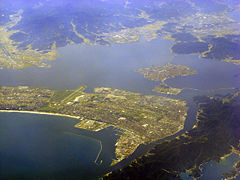
Nakaumi (中海?) is a brackish lake located between Tottori and Shimane prefectures in Japan. The lake is enclosed by the Shimane Peninsula to the north and Yumigahama Peninsula to the east. It is the fifth largest lake in surface area in Japan.

Nakaumi connects Lake Shinji (宍道湖 Shinji-ko) and the Sea of Japan, and is surrounded by the municipalities Matsue, Yasugi, Yonago and Sakaiminato.

There are two large islands in the lake, Daikon Island (大根島 Daikonjima, lit. "radish island") and Eshima Island (江島 Eshima, "river island"). There are bridges and roads that connect the east and west shores of the lake through the two islands.

Nakaumi is a brackish lake because it is connected to the Sea of Japan by a short channel, the Sakai Channel, and lies so low that the tides reverse the flow of the rivers all the way into Lake Shinji.

Nakaumi (中海) literally means "middle sea". Even though Nakaumi is a lake, it was likely named a sea because of its saline water and proximity to the actual sea. In Japanese, the lake is usually referred to simply as Nakaumi, not as Nakaumi-ko (Lake Nakaumi).

See also


Wikimedia Foundation. 2010.

Игры ⚽ Нужно сделать НИР?

Look at other dictionaries:

  • Shimane Prefecture — Infobox Prefecture Japan Name = Shimane JapaneseName = 島根県 Rōmaji = Shimane ken Symbol = PrefSymbol Shimane.png Capital = Matsue Region = Chūgoku Island = Honshū TotalArea = 6,707.29 AreaRank = 18th PCWater = 2.7 PopDate = October 1, 2000… …   Wikipedia

  • Matsue, Shimane — Matsue 松江   City   松江市 · Matsue From top left:Kumano Ta …   Wikipedia

  • Sakaiminato, Tottori — Infobox City Japan Name= Sakaiminato JapaneseName= 境港市 Map Region=Chūgoku (San in) Prefecture=Tottori District= Area km2=28.79 PopDate=May 2008 Population=35,710 Density km2=1240 Coords= LatitudeDegrees= 35 LatitudeMinutes= 32 LatitudeSeconds=… …   Wikipedia

  • Lake Shinji — Infobox lake lake name = Lake Shinji image lake = Matue sinjiko01.jpg caption lake = View from Matsue Castle image bathymetry = caption bathymetry = location = Shimane Prefecture coords = coord|35|27|N|132|58|E|region:JP 32 type:waterbody|display …   Wikipedia

  • Daikon Island — Elevation 42 m (138 ft) Location Location …   Wikipedia

  • Liste der Seen in Japan — Diese Liste der (natürlichen) Seen in Japan (ab einer Fläche von 4 km²) ist per Standard nach Fläche sortiert. Die Daten basieren auf Angaben des japanischen Ministeriums für Land, Infrastruktur und Transport (siehe Weblinks) aus dem Jahr 2002.… …   Deutsch Wikipedia

  • Sakaiminato — shi 境港市 Geographische Lage in Japan …   Deutsch Wikipedia

  • Shinsen Gumi — Isami Kondō Le Shinsen Gumi (新選組, Shinsen Gumi …   Wikipédia en Français

  • Shinsengumi — Shinsen Gumi Isami Kondō Le Shinsen Gumi (新選組, Shinsen Gumi …   Wikipédia en Français

  • Дайкон (значения) — Дайкон: Дайкон японская редька. Дайкон остров в озере Накоми (Nakaumi). Дайкон (англ. Daicon) фестиваль (конвенция) анимационного кино в стиле аниме. Дайкон (англ. Daicon Film) первое название японской анимационной студии Gainax …   Википедия

Share the article and excerpts

Direct link
Do a right-click on the link above
and select “Copy Link”