- Cropmark
-
- See crop mark for disambiguation.
Cropmarks or Crop marks are a means through which sub-surface archaeological, natural and recent features may be visible from the air or a vantage point on higher ground or a temporary platform. Along with soil marks and frost marks they can reveal buried archaeological sites not visible from the ground.
Contents
Description
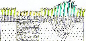
Crop marks appear due to the principle of differential growth. One of the factors controlling the growth of vegetation is the condition of the soil. A buried stone wall for example will affect crop growth above it, as its presence channels water away from its area and occupies the space of the more fertile soil. Conversely, a buried ditch, with a fill containing more organic matter than the natural earth, provides much more conducive conditions and water will naturally collect there, nourishing the plants growing above.
The differences in conditions will cause some plants to grow more strongly and therefore taller, and others less strongly and therefore shorter. Some species will also react through differential ripening of their fruits or their overall colour.
Particularly effective crops that exhibit differential growth well include cereal crops, peas, and potatoes.
Differential growth will naturally follow any features buried below. Although the growth differences may appear small close up, from the air the pattern they make is more visible as the small changes can be seen in the context of the normally growing surrounding vegetation as differences in tone or colour. When the sun is low to the horizon, shadows cast by the taller crops can also become visible.
By their nature crop marks are only visible seasonally and may not be visible at all except in exceptionally wet or dry years. Droughts can be especially useful to cropmark hunters as the differential growth can become apparent in normally hardy species such as grass. The drought of 2010 produced particularly good conditions for observing crop marks in the UK.[1]
The usefulness of cropmarks to archaeologists has largely been a fruit of inspection from aircraft, but the possibility was suggested by Rev. Gilbert White in The Natural History of Selborne (1789), in a note appended to his Letter VI, to Thomas Pennant, apropos of local people's success in searching for bog oak for house construction, by discovering these trees "by the hoar frost, which lay longer over the space where they were concealed, than on the surrounding morass. To White it suggested the query "might not such observations be reduced to domestic use, by promoting the discovery of old obliterated drains and wells about houses; and in Roman stations and camps lead to the finding of pavements, baths and graves, and other hidden relics of curious antiquity?"
Examples
Examples of archaeological sites where cropmarks have been observed are Balbridie and Fetteresso in Scotland.
In 2009, investigation of crop marks near Stonehenge revealed a variety of 6,000 year old prehistoric subterranean structures.[2]
Another example is the rediscovery of Altinum, a precursor to the city of Venice, from a combination of visible and near-infrared photos of the area taken during a drought in 2007.
The multi period site at Mucking was discovered as a result of aerial photographs showing cropmarks and soil marks. The earliest photographs to reveal the site were taken by the Luftwaffe in 1943.[3] The importance of the site was recognised following photographs taken by Dr JK St. Joseph in 1959[3] (published in 1964).[4] In 1982, Margaret Jones (site director at the Mucking excavation) noted that some sites were being interpreted on crop mark evidence alone. She pointed out that some features do not produce crop marks and that some crop marks, when excavated, turn out not to be what they seem.[5]
See also
References
Wilson, D. R . 2000 Air photo interpretation for archaeologists (2nd edn.), London.
- ^ BBC news, reporting English Heritage
- ^ James Owen (2009-06-15). "Huge Pre-Stonehenge Complex Found via "Crop Circles"". National Geographic. http://news.nationalgeographic.com/news/2009/06/090615-stonehenge-tombs-crop-circles.html.
- ^ a b Clark, A. 1993. Excavations at Mucking, Volume 1: The Site Atlas (English Heritage Archaeological Report 20)
- ^ JK St Joseph, Air reconnaissance: recent results (Antiquity, vol 38, pp 217-218)
- ^ Jones, Margaret. "Jottings from Mucking post-excavation". Panorama 25.
External links
Categories:- Methods and principles in archaeology
Wikimedia Foundation. 2010.

