- Chiuduno
-
Chiuduno — Comune — Comune di Chiuduno Chiuduno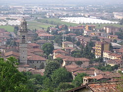

Coat of armsLocation of Chiuduno in Italy
 Chiuduno
Coordinates: 45°39′N 9°51′E / 45.65°N 9.85°ECoordinates: 45°39′N 9°51′E / 45.65°N 9.85°E Country Italy Region Lombardy Province Bregamo (BG) Frazioni Cicola, Valle del Fico Government - Mayor Mauro Cinquini Area - Total 6.6 km2 (2.5 sq mi) Elevation 218 m (715 ft) Population (Dec. 2004)[1] - Total 5,348 - Density 810.3/km2 (2,098.7/sq mi) Demonym Chiudunesi Time zone CET (UTC+1) - Summer (DST) CEST (UTC+2) Postal code 24060 Dialing code 035 Patron saint St. Lucius Saint day October 30 Chiuduno is a comune (municipality) in the Province of Bergamo in the Italian region of Lombardy, located about 60 km northeast of Milan and about 15 km southeast of Bergamo, mid way between the Bergamo plain and the Valcalepio.
Chiuduno borders the following municipalities: Bolgare, Carobbio degli Angeli, Grumello del Monte, Telgate.
Contents
History
The settlement has Gaulish origins, and was later a Roman centre as Claudunum on the road between Bergamo and Brescia. It is however mentioned for the first time in a document from 795, and in the Middle Ages it developed and received a fortress.
Main sights
- Castle (9th century), of which only a tower and other parts remain.
- Another fortification on the border with the territory of Carobbio degli Angeli (17th century).
Demographic evolution

References
Categories:- Cities and towns in Lombardy
- Communes of the Province of Bergamo
- Province of Bergamo geography stubs


Wikimedia Foundation. 2010.