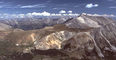
- Mount Shavano
-
Mount Shavano
The Southeast face of Mt. ShavanoElevation 14,231 ft (4,338 m) NAVD 88[1] Prominence 1,619 ft (493 m) [2] Listing Colorado Fourteener Location Mount Shavano Location Chaffee County, Colorado, USA Range Rocky Mountains, Sawatch Range Coordinates 38°37′09″N 106°14′22″W / 38.61917°N 106.23944°WCoordinates: 38°37′09″N 106°14′22″W / 38.61917°N 106.23944°W[1] Topo map USGS Maysville Climbing Easiest route Hike Mount Shavano, with an altitude of 14,229 feet (4,337 meters), is one of the fourteeners of the U.S. State of Colorado. It is the 17th highest peak in Colorado and a near-neighbor to Tabeguache Peak. It lies just east of the Continental Divide and just west of the Arkansas River rising 7,000 feet above the town of Salida in Chaffee County to the southeast. Mount Shavano lies in the south-central part of the Sawatch Range, north of Mount Ouray and Mount Chipeta and south of the Collegiate Peaks (including Mount Princeton, Mount Harvard, and Mount Yale). Mount Shavano is famous for the Angel of Shavano, a snow formation in the image of an angel that emerges on the east face of the mountain during snow melt each spring.[3]
Mount Shavano is located within the San Isabel National Forest and was named after Chief Shavano of the Ute Tribe.
References
- ^ a b "Shavano". NGS data sheet. U.S. National Geodetic Survey. http://www.ngs.noaa.gov/cgi-bin/ds_mark.prl?PidBox=JL0887. Retrieved 2011-02-21.
- ^ "Mount Shavano, Colorado". Peakbagger.com. http://www.peakbagger.com/peak.aspx?pid=5762. Retrieved 2011-02-23.
- ^ Louis W. Dawson II, Dawson's Guide to Colorado's Fourteeners, Volume 1, Blue Clover Press, 1994, ISBN 0-9628867-1-8
See also
- Colorado fourteeners
- Colorado mountain ranges
- Mountain peaks of Colorado
 The view north from the Northwest approach of Mount Shavano, with Mt. Antero at center-right. Mt. Princeton, Mt. Yale, and Mt. Harvard, are also visible in the distance.
 Categories:
- Mountains of Colorado
- Geography of Chaffee County, Colorado
- Fourteeners of Colorado
Wikimedia Foundation. 2010.


