- Ice Runway
-
Coordinates: 77°51′14″S 166°28′07″E / 77.85389°S 166.46861°E
Ice Runway 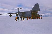
C-5 Galaxy unloading at sea ice runway, near McMurdo Station, 1999. IATA: none – ICAO: NZIR Summary Location McMurdo Station, Ross Island, Antarctica Elevation AMSL 1 ft / 0 m Runways Direction Length Surface ft m 11/29 10,000 3,048 Ice 16/34 10,000 3,048 Ice Source: DAFIF [1][2]  C-141 Starlifter on Ice Runway, near McMurdo Station, 1996.
The Ice Runway (ICAO: NZIR) is the principal runway for the US Antarctic Program during the summer Antarctic field season due to its proximity to McMurdo Station. The other two runways in the area are the snow runway at Williams Field (ICAO: NZWD) and the white ice runway at Pegasus Field (ICAO: NZPG}.
This runway is capable of handling wheeled aircraft, that have included to date: Lockheed C-5 Galaxy, Lockheed C-141 Starlifter, Boeing C-17 Globemaster III, Lockheed C-130 Hercules and Lockheed P-3 Orion. In the summer season of 2009 /2010 the RNZAF trialled a modified Boeing 757 operationally. The intention is to use the Boeing 757 for passenger transport thereby freeing up capacity for C17 cargo space. [3]
The annual sea-ice runway for wheeled aircraft is constructed at the start of each season and is used until early December when the sea ice begins to break up.[4] Subsequently flight operations are moved back to Williams Field. Pilots landing C-17 Globemaster III cargo aircraft on the sea ice runway report that the surface is stable, not unlike landing on concrete. However, the similarity with land bases ends when the jet aircraft rolls to a stop. The nearly 450,000 pound weight of the plane, including cargo and passengers, causes it to sink into the ice, albeit only a matter of inches. A laser light is trained on the aircraft to measure the settlement rate. The $200 million aircraft is moved to a new location on the six-foot-thick ice as a safety measure if the 10-inch red line is reached, according to the News Tribune in Tacoma, Washington.[citation needed]
See also
References
- ^ Airport information for NZIR at World Aero Data. Data current as of October 2006.Source: DAFIF.
- ^ Airport information for NZIR at Great Circle Mapper. Source: DAFIF (effective Oct. 2006).
- ^ http://www.airforce.mil.nz/operations/media-releases/media-release.htm@guid=%7B743a1ebd-84d8-47a9-970e-e950ea91c749%7D.htm.
- ^ Blue-ice and snow runways, National Science Foundation Office of Polar Programs. April 9, 1993.
External links
- Ambling through Ice Town, Antarctic Sun. November 28, 1999.
- Navy WV-2 Super Connie Crash at McMurdo Sound in 1960
- Moving the Airport, December 21, 1999.
- Current weather for NZIR at NOAA/NWS
Categories:- Airports in the Ross Dependency
- McMurdo Station


Wikimedia Foundation. 2010.