- Pegasus Field
-
Coordinates: 77°57′48″S 166°31′28″E / 77.96333°S 166.52444°E
Pegasus Field 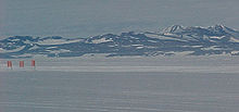
White ice runway at Pegasus Field IATA: none – ICAO: NZPG Location of airfield in Antarctica
 NZPG
NZPGSummary Location McMurdo Station, Ross Island, Antarctica Elevation AMSL 18 ft / 5 m Runways Direction Length Surface ft m 15/33 10,000 3,048 Ice Source: DAFIF [1][2] Pegasus Field (ICAO: NZPG) is an airstrip in Antarctica, the southernmost of three airfields serving McMurdo Station. Pegasus is a white ice runway capable of handling wheeled aircraft year-round. The other two are the snow runways at Williams Field that is limited to ski-equipped aircraft, and the principal Ice Runway on the sea-ice available during the summer Antarctic field season.
The field is named after Pegasus, a C-121 Lockheed Constellation, still visible there in the snow after crashing in bad weather on October 8, 1970. No one on board was injured.
On September 11, 2008, a United States Air Force C-17 Globemaster III successfully completed the first landing in Antarctica using night-vision goggles at Pegasus Field.[3] Previously air transport in the permanent darkness of the winter was only used in emergencies, with burning barrels of fuel to outline the runway.
References
- ^ Airport information for NZPG at World Aero Data. Data current as of October 2006.Source: DAFIF.
- ^ Airport information for NZPG at Great Circle Mapper. Source: DAFIF (effective Oct. 2006).
- ^ Rejcek, Peter (September 26, 2008). "Air Force successfully tests new capability to fly any time of year to McMurdo". Antarctic Sun. http://antarcticsun.usap.gov/features/contenthandler.cfm?id=1544.
External links
- The McMurdo "Pegasus Site" from "Airfields on Antarctic Glacier Ice" by Malcolm Mellor and Charles Swithinbank, CRREL 1989.
- Lockheed Aircraft R7V-1 / R7V-1P / C-121J "Constellation" "Connie"
- Installation of runway-Pegasus
- Runway Project Clears the Way for Improved Antarctic Airlift, National Science Foundation. February 20, 2002.
- Current weather for NZPG at NOAA/NWS
Categories:- Airports in the Ross Dependency
- McMurdo Station


Wikimedia Foundation. 2010.