- Dales Way
-
Dales Way 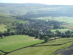
Kettlewell lies on the trail Length 135 kilometres (84 mi) Location Northern England Trailheads Ilkley, Yorkshire
Bowness-on-Windermere, CumbriaUse Hiking Highest point Cam Houses, 1,600 ft (488 m) The Dales Way is an 84-mile (135 km) Long Distance Footpath in Northern England, from (south east to north west) Ilkley, West Yorkshire to Bowness-on-Windermere, Cumbria.
The Dales Way passes through two National Parks: the Yorkshire Dales National Park and the Lake District National Park. The first half of the walk follows the River Wharfe upstream to the main watershed of northern England at Ribblehead. The second half follows several river valleys (Dentdale, River Mint, River Kent) to descend to the shores of Windermere.
Contents
Background
The walk is shorter and less strenuous than more well-known routes such as the Pennine Way and Coast to Coast Walk, being mostly along river valleys. It thus makes a good introductory training ground for these "serious" walks while being well worth doing in its own right. The section from upper Wharfedale (Langstrothdale) over the watershed at Cam Houses and down into Ribblesdale is steep (going up AND down).
It is feasible (for those more interested in a challenge than the enjoyment of the walk) to complete the walk the route in around four days, but most walkers take about a week, dividing the route into sections of 10 to 15 miles per day and taking a "rest day" or two.
Planning an itinerary is generally easy. Public transport (including Windermere "steamers") is good at both ends of the route (train stations at Ilkley and Windermere). The popularity of the walk (and the area generally) means that there are many choices of accommodation - for instance, nearly all pubs along the route do Bed and Breakfast.
Notable places
The largest settlements on the route are Ilkley and Bowness-on-Windermere at either end, and the small town of Sedbergh in Dentdale. The town of Kendal (larger than the other places mentioned) is not far from the route.
Another notable place is the stone village of Dent, with very little modern housing. Along Wharfedale, the route passes through the villages of Grassington and Kettlewell.
Connecting trails
Just before it reaches the end at Bowness-on-Windermere the route connects with the Windermere Way. Other connecting trails may be found on the Dales Way page of the Long Distance Walkers' Association website.
Warning
Less-experienced walkers should take care when planning the central section (over the watershed). This section has, of course, the greatest ascent and descent, and is rather remote for anyone who finds themselves in difficulties. The less-fit walker needs to arrange accommodation in order to make this section as short as possible. This will almost certainly involve at least one night in a remote farmhouse or pub, because the novice will probably find that the climbing involved will make the walk from Kettlewell or Buckden to Dentdale much too long a day. This is not too difficult to arrange as there are pubs at Hubberholme and Ribblehead, and farmhouse/bunkhouse accommodation in Langstrothdale and (on top of the watershed) at Cam Houses.
External links
- The Dales Way
- Dales Way Organisation
- The Long Distance Walkers' Association
- Dales Way 2005 Journal from kevanliz
- Walking Englishman

Wikimedia Foundation. 2010.