- Narva River
-
Narva (Estonian: Narva jõgi) River 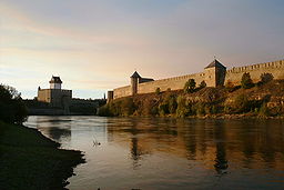 Narva River with Hermann Castle and Ivangorod Fortress
Countries Estonia, Russia Tributaries - left Jaama River, Poruni River, Mustajõgi - right Plyussa River, Rosson River Cities Narva, Ivangorod, Narva-Jõesuu Source Lake Peipsi - elevation 30 m (98 ft) - coordinates 58°59′14″N 27°43′50″E / 58.98722°N 27.73056°E Mouth Narva Bay in Finnish Gulf - elevation 0 m (0 ft) - coordinates 59°28′14″N 28°02′37″E / 59.47056°N 28.04361°E Length 77 km (48 mi) Width 0.3 km (0 mi) Depth 5 m (16 ft) Basin 56,225 km2 (21,709 sq mi) Discharge - average 400 m3/s (14,126 cu ft/s) Basin countries Russia (62.9%), Estonia (30.5%), Latvia (6.6%),[1] Belarus (minute share)(see map) 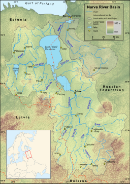 Map of Narva River and Lake Peipsi basins
The Narva (or Narova) is a river flowing into the Baltic Sea, the largest river in Estonia. Draining Lake Peipsi, the river forms the border of Estonia and Russia and flows through the towns of Narva/Ivangorod and Narva-Jõesuu into Narva Bay. Though the river is only 77 km long, in terms of volume discharged it is the second largest river flowing into the Finnish Gulf. The river gives its name to the Narva culture and the city of Narva.
Contents
Etymology
The etymology of the toponym Narva is not clear, but according to the most common theory it comes from a Vepsian word narva meaning waterfall or stream.[2].
Geography
The Narva river has its source at the northeastern end of Lake Peipsi, near the villages of Vasknarva (Estonia) and Skamya (Russia). There are a few more small villages on the upper section of the river, for example Permisküla and Kuningaküla on the Estonian side and Omuti on the Russian side, but up to the city of Narva the shores of the river are mostly forested or marshy. The river is dammed entering Narva and Ivangorod, forming the Narva Reservoir, which extends up to 38 km upstream.[3] Narva flows into Narva Bay near the Estonian town of Narva-Jõesuu, third largest settlement on the river after Narva and Ivangorod.
The River Plyussa is the largest tributary, joining Narva at the Narva Reservoir.
Narva Waterfall
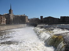 Narva Waterfall (eastern part) in spring 2010
Between Narva and Ivangorod the river flows over the Baltic Klint, forming the Narva Waterfall, once among the most powerful in Europe.[4] As before the falls[clarification needed] the island of Kreenholm divides the river into two branches, thus the falls consist of two sections: Kreenholm Falls to the west of the island (60 m in width, 6.5 m high with multiple terraces) and Joala Falls to the east (110 m in width, up to 6.5 m high). The Estonian-Russian border follows the eastern branch and goes through Joala Falls.[4]
Since the damming of the river in 1955 the waterfalls are usually dry, but water is allowed to flow in the original channel for up to a few days every year. Access to the waterfalls is difficult as they are located in the border zone and the surrounding area on the Estonian side is closed industrial land belonging to Krenholm Manufacture.
Bridges
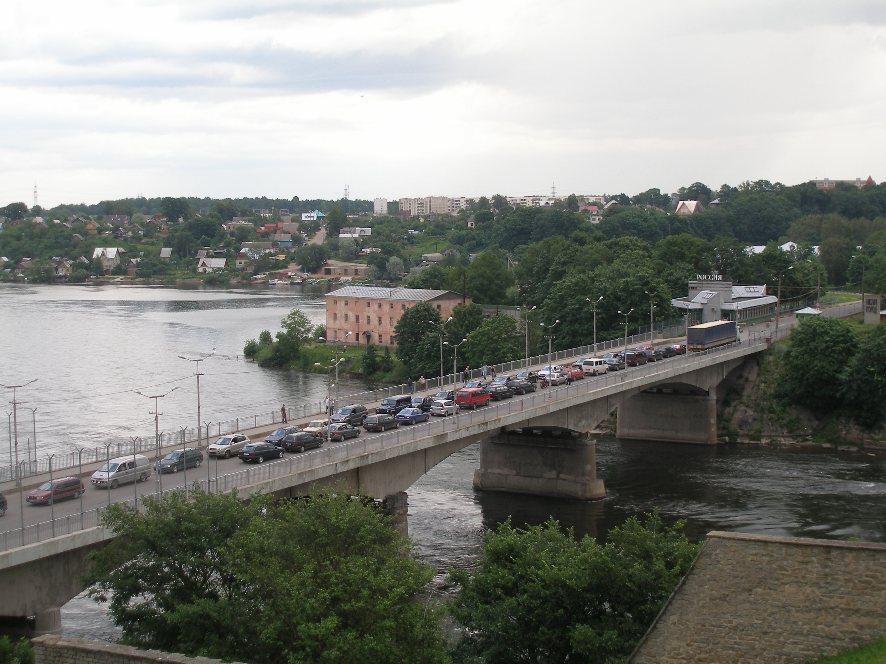
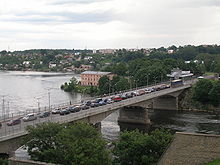 Tallinn-St. Petersburg highway bridge
The Narva River is crossed only by a handful of bridges between Narva and Ivangorod. Besides the dam of the Narva Reservoir, these are, in downstream order:
- a pedestrian bridge below the Kreenholm island
- Tallinn-St. Petersburg railway bridge
- Tallinn-St. Petersburg highway bridge on E20 just downstream from the Hermann Castle and Ivangorod fortress. The bridge named Friendship Bridge was built in 1960 and is 162 m long.
History
Narva River was used as a trade route during the Viking Age, from 5th to 11th century. It was an offshoot of the trade route from the Varangians to the Greeks.[5]
Narva has for centuries been an important border river. Beginning in the 13th century it was the border of Medieval Livonia and the Novgorod Republic.[6] Though in earlier periods Narva was part of a larger buffer zone between the two territories, gradually the river emerged as the exact border.[6] Castles built on the river banks (Narva Hermann Castle, founded at the beginning of 14th century, Ivangorod fortress, established in 1492 and Vasknarva Castle, first built in the 14th century) were one of the main reasons behind this. Treaties from the 15th century between the Livonian Order and Novgorod Republic also recognize Narva River as the border.[6] During the time of Swedish Estonia, when Ingria was also part of Sweden, the importance of the river as a border diminished. During the Russian Empire, from the end of the Great Northern War until the establishment of the Republic of Estonia in 1918, the Narva River was the border of Governorate of Estonia and Saint Petersburg Governorate, with the exception of the town of Narva, which was part of the latter. By the Treaty of Tartu, signed in 1920, the Estonian-Russian border went slightly east of the river, up to 10 km. In 1944 the former Estonian territory east of the river was transferred to Russian SFSR and Narva was thus established as the eastern border of Estonian SSR, an internal border within USSR. In 1991 the same border became the de facto border of Estonia and Russia. Although no official border treaty has been ratified since then,[7] today Narva River is the eastern border of the European Union and Schengen Zone.
References
- ^ Nõges, Peeter; Järvet, Arvo (2005). "Climate driven changes in the spawning of roach and bream in the Estonian part of the Narva River basin". Boreal Environment Research 10. http://www.borenv.net/BER/pdfs/ber10/ber10-045.pdf.
- ^ "Formation of city". Narva Museum. http://www.narvamuuseum.ee/?next=kujunemine&lang=eng&menu=menu_ajalugu. Retrieved 2009-01-11.
- ^ (Estonian)"Sada aastat Narva jõe äravoolu mõõtmisi". Eesti Loodus. http://www.loodusajakiri.ee/eesti_loodus/index.php?id=230. Retrieved 2009-01-11.
- ^ a b (Estonian) Suuroja, Kalle (2005). Põhja-Eesti klint. Eesti Geoloogiakeskus. ISBN 998581553X.
- ^ "Narva - History". http://tourism.narva.ee/?mid=60. Retrieved 2009-02-13.
- ^ a b c (Estonian) Selart, Anti (1996). "Narva jõgi - Virumaa idapiir keskajal". Akadeemia 8 (12).
- ^ "Russian-Estonian border agreement will be ratified". New Europe. 22 September 2007. http://www.neurope.eu/articles/78037.php. Retrieved 13 February 2009.
Categories:- Rivers of Leningrad Oblast
- Rivers of Estonia
- International rivers of Europe
- Ida-Viru County
- Narva
- Ingria
- Votia
- Estonia–Russia border
- Narva River basin


Wikimedia Foundation. 2010.