- Oberburg
-
Oberburg Country Switzerland 
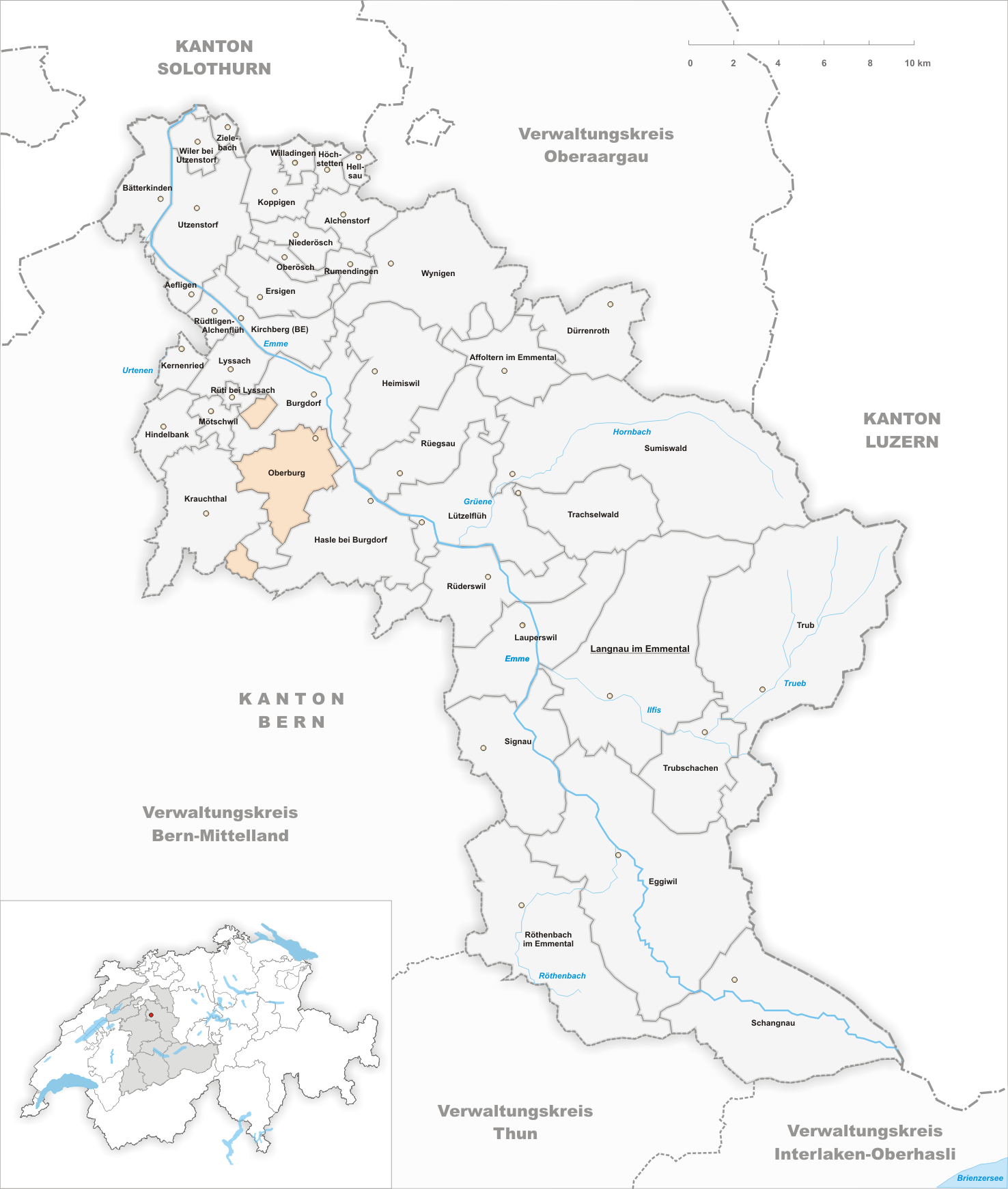
Canton Bern District Emmental 47°2′N 7°38′E / 47.033°N 7.633°ECoordinates: 47°2′N 7°38′E / 47.033°N 7.633°E Population 2,881 (Dec 2010)[1] - Density 204 /km2 (529 /sq mi) Area 14.12 km2 (5.45 sq mi)[2] Elevation 547 m (1,795 ft) Postal code 3414 SFOS number 0418 Surrounded by Burgdorf, Hasle bei Burgdorf, Krauchthal, Lützelflüh, Mötschwil, Rüti bei Lyssach, Vechigen Website www.oberburg.ch
SFSO statistics
 OberburgMap of Oberburg
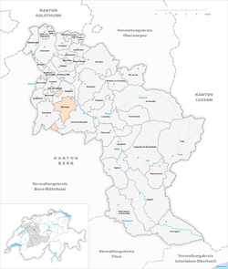
Oberburg is a municipality in the administrative district of Emmental in the canton of Bern in Switzerland.
Contents
History
Oberburg is first mentioned in 1240 as Obrunburc.[3]
Geography
Oberburg has an area, as of 2009[update], of 14.12 km2 (5.45 sq mi). Of this area, 7.88 km2 (3.04 sq mi) or 55.8% is used for agricultural purposes, while 4.7 km2 (1.8 sq mi) or 33.3% is forested. Of the rest of the land, 1.49 km2 (0.58 sq mi) or 10.6% is settled (buildings or roads), 0.06 km2 (15 acres) or 0.4% is either rivers or lakes and 0.02 km2 (4.9 acres) or 0.1% is unproductive land.[4]
Of the built up area, housing and buildings made up 4.7% and transportation infrastructure made up 2.8%. while parks, green belts and sports fields made up 2.1%. 32.2% of the total land area is heavily forested and 1.1% is covered with orchards or small clusters of trees. Of the agricultural land, 19.8% is used for growing crops and 34.3% is pastures, while 1.7% is used for orchards or vine crops. All the water in the municipality is in rivers and streams.[4]
The village stretchs along the left bank of the Emme River (except for Schachen- and Uferanteil) in the Luterbachgraben (Luter creek valley) in includes the villages of Oberburg, Weiler, several individual farms and the exclaves Rohrmoos und Tannen.
Demographics
Oberburg has a population (as of 31 December 2010) of 2,881.[1] As of 2007[update], 16.4% of the population was made up of foreign nationals. Over the last 10 years the population has grown at a rate of 1.6%. Most of the population (as of 2000[update]) speaks German (89.7%), with Serbo-Croatian being second most common ( 3.0%) and Italian being third ( 2.1%).
In the 2007 election the most popular party was the SVP which received 44.9% of the vote. The next three most popular parties were the SPS (16.7%), the FDP (10.8%) and the local small left-wing parties (8.5%).
The age distribution of the population (as of 2000[update]) is children and teenagers (0–19 years old) make up 23.2% of the population, while adults (20–64 years old) make up 61.4% and the seniors (over 64 years old) make up 15.3%. In Oberburg about 68.9% of the population (between age 25-64) have completed either non-mandatory upper secondary education or additional higher education (either university or a Fachhochschule).
Oberburg has an unemployment rate of 2.27%. As of 2005[update], there were 174 people employed in the primary economic sector and about 59 businesses involved in this sector. 428 people are employed in the secondary sector and there are 34 businesses in this sector. 559 people are employed in the tertiary sector, with 70 businesses in this sector.[5] The historical population is given in the following table:[3]
year population 1764 799 1850 2,200 1900 2,745 1950 2,990 2000 2,740 References
- ^ a b Swiss Federal Statistical Office - STAT-TAB, online database – Datenwürfel für Thema 01.2 - Bevölkerungsstand und -bewegung (German) accessed 29 September
- ^ Arealstatistik Standard - Gemeindedaten nach 4 Hauptbereichen
- ^ a b Oberburg in German, French and Italian in the online Historical Dictionary of Switzerland.
- ^ a b Swiss Federal Statistical Office-Land Use Statistics 2009 data (German) accessed 25 March 2010
- ^ Swiss Federal Statistical Office accessed 04-Jun-2009
Aefligen | Affoltern im Emmental | Alchenstorf | Bätterkinden | Burgdorf | Dürrenroth | Eggiwil | Ersigen | Hasle bei Burgdorf | Heimiswil | Hellsau | Hindelbank | Höchstetten | Kernenried | Kirchberg | Koppigen | Krauchthal | Langnau im Emmental | Lauperswil | Lützelflüh | Lyssach | Mötschwil | Niederösch | Oberburg | Oberösch | Röthenbach im Emmental | Rüderswil | Rüdtligen-Alchenflüh | Rüegsau | Rumendingen | Rüti bei Lyssach | Schangnau | Signau | Sumiswald | Trachselwald | Trub | Trubschachen | Utzenstorf | Wiler bei Utzenstorf | Willadingen | Wynigen | Zielebach
Canton of Bern | Districts of Canton Bern | Municipalities of the canton of Bern
 Categories:
- Municipalities of Bern
- Municipalities of Switzerland


Wikimedia Foundation. 2010.