- Ehrendingen
-
Ehrendingen 
Country Switzerland 
Canton Aargau District Baden 47°30′N 8°21′E / 47.5°N 8.35°ECoordinates: 47°30′N 8°21′E / 47.5°N 8.35°E Population 4,164 (Dec 2010)[1] - Density 570 /km2 (1,475 /sq mi) Area 7.29 km2 (2.81 sq mi)[2] Elevation 450 m (1,476 ft)
at Lägern MountainsPostal code 5420 SFOS number 4049 Mayor Renato Sinelli (as of 2006-2009) Pro Ehrendingen Surrounded by Schneisingen, Niederweningen, Wettingen, Ennetbaden, Freienwil, Lengnau Website www.ehrendingen.ch
SFSO statistics
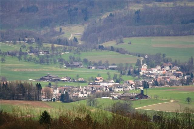
 EhrendingenMap of Ehrendingen

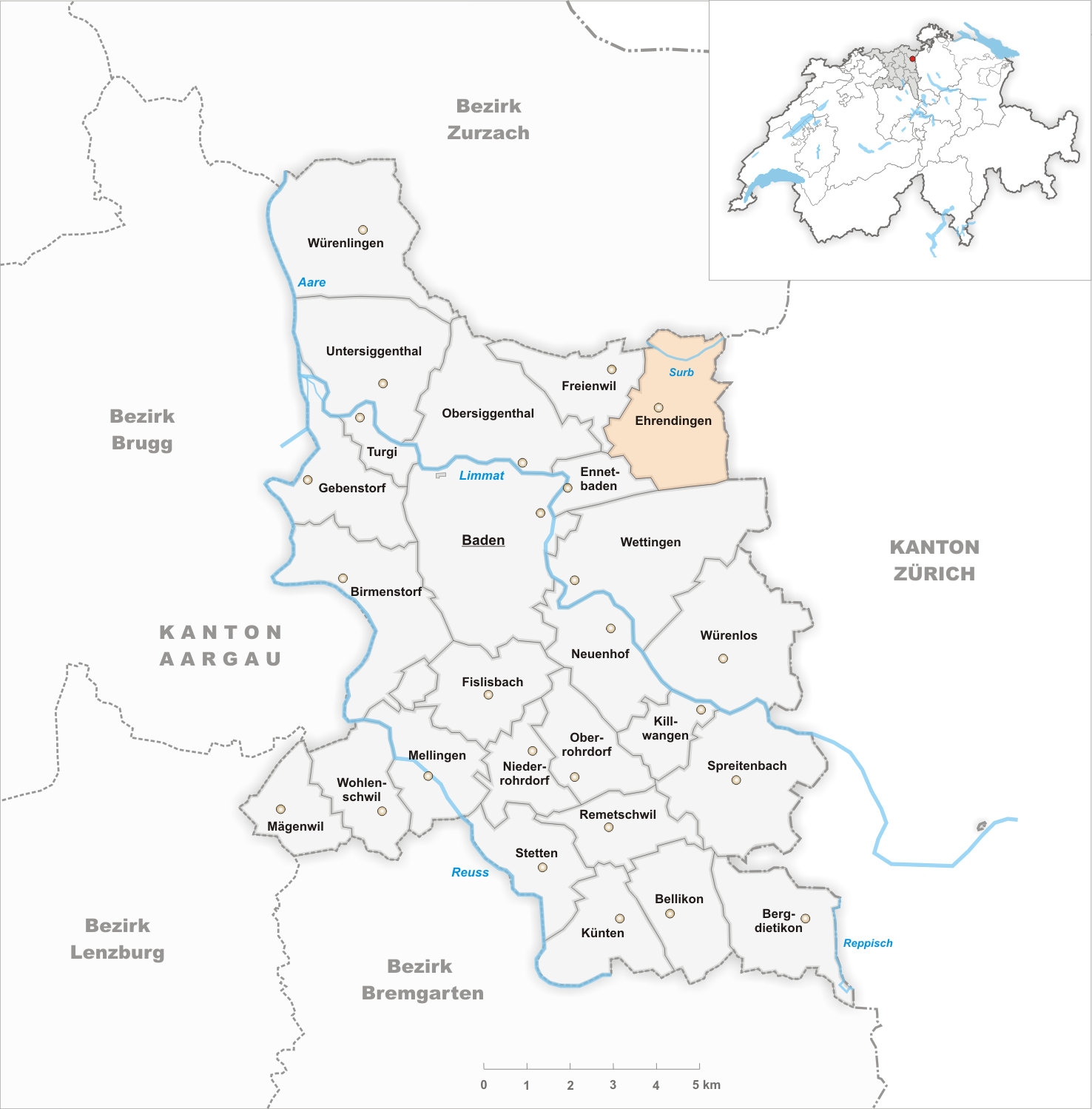
Ehrendingen is a municipality in the district of Baden in the canton of Aargau in Switzerland.
Contents
History
Ehrendingen was formed on January 1, 2006 from the union of Oberehrendingen and Unterehrendingen, which have existed as separate municipalities since 1825.[3]
Geography
Ehrendingen has an area, as of 2006[update], of 7.3 km2 (2.8 sq mi). Of this area, 58.3% is used for agricultural purposes, while 28.5% is forested. Of the rest of the land, 13.1% is settled (buildings or roads) and the remainder (0.1%) is non-productive (rivers or lakes).[4]
The municipality lies on the northern foot of the Lägern. It belongs to the Zurich Metropolitan Area, though is on the edge of the Area. The next largest city would be Baden, which has a population of about 17,000. The two parts of the village has grown together and follow a creek where it rises to the Lägern.
In 2006 the municipality was created through the merger of Oberehrendingen and Unterehrendingen.[5]
Demographics
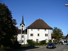 Ehrendingen village and town hall
Ehrendingen has a population (as of 31 December 2010) of 4,164.[1] As of 2008[update], 14.6% of the population was made up of foreign nationals.[6] Over the last 10 years the population has grown at a rate of 21.2%. Most of the population (as of 2000[update]) speaks German (92.2%), with Italian being second most common ( 1.5%) and English being third ( 1.0%).[4]
The age distribution, as of 2008[update], in Ehrendingen is; 458 children or 11.5% of the population are between 0 and 9 years old and 497 teenagers or 12.5% are between 10 and 19. Of the adult population, 393 people or 9.9% of the population are between 20 and 29 years old. 525 people or 13.2% are between 30 and 39, 727 people or 18.3% are between 40 and 49, and 532 people or 13.4% are between 50 and 59. The senior population distribution is 447 people or 11.3% of the population are between 60 and 69 years old, 271 people or 6.8% are between 70 and 79, there are 106 people or 2.7% who are between 80 and 89,and there are 10 people or 0.3% who are 90 and older.[7]
According to the census in 2000, 52.3% were Roman Catholic, 31.8% Protestant, 2.2% Muslim and 1.4 % belong to another faith.
In the 2007 federal election the most popular party was the SVP which received 36.8% of the vote. The next two most popular parties were the CVP (17.1%), and the FDP (10.8%).[4]
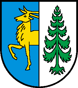
Coat of arms
The municipal coat of arms of the blazon reads: Divided by blue, with the dividing line, yellow deer border and white, from cracked green fir, the symbols of the sub-arms of Unterehrendingen and Oberehrendingen
Historic population
Population from 1900–2010 Year Population 1900 966 1930 1135 1950 1337 1960 1653 1970 2362 1990 2958 2000 3299 2010 4207 Education
Ehrendingen has four kindergartens, a primary school, a secondary school and a Realschule. The highest school, the Bezirksschule (district school), may be visited in Baden or in Endingen. After four years in the Bezirksschule students with a good grade point average (4,7) can go to the Kantonsschule (state school/college), which lasts 4 years and is located in Baden.
The entire Swiss population is generally well educated. In Ehrendingen about 84.1% of the population (between age 25-64) have completed either non-mandatory upper secondary education or additional higher education (either university or a Fachhochschule).[4] Of the school age population (in the 2008/2009 school year[update]), there are 341 students attending primary school, there are 139 students attending secondary school in the municipality.[8]
Transport and Traffic
Ehrendingen is located on the Route 17, between Baden and the Surb valley, a side road leads to Freienwil. The village is enclosed by two Postauto lines that traffic from Baden to Döttingen and to Kaiserstuhl. Ehrendingen has six bus stations. The neighboring village Niederweningen has a railway station to Zurich. During the year 2009, will be 4 new buses on the Ehrendingen-Baden route.
Economy
As of 2007[update], Ehrendingen had an unemployment rate of 2.08%. As of 2005[update], there were 88 people employed in the primary economic sector and about 30 businesses involved in this sector. 165 people are employed in the secondary sector and there are 47 businesses in this sector. 365 people are employed in the tertiary sector, with 75 businesses in this sector.[4]
References
- ^ a b Canton of Aargau Statistical Office, MS Excel document – Bevölkerungsbestand per 31.12.2010 nach Gemeinde, Geschlecht u. Nationalität (German) accessed 11 May 2011
- ^ Arealstatistik Standard - Gemeindedaten nach 4 Hauptbereichen
- ^ Ehrendingen in German, French and Italian in the online Historical Dictionary of Switzerland.
- ^ a b c d e Swiss Federal Statistical Office accessed 05-February-2010
- ^ Amtliches Gemeindeverzeichnis der Schweiz published by the Swiss Federal Statistical Office (German) accessed 14 January 2010
- ^ Statistical Department of Canton Aargau -Bereich 01 -Bevölkerung (German) accessed 20 January 2010
- ^ Statistical Department of Canton Aargau -Bevölkerungsdaten für den Kanton Aargau und die Gemeinden (Archiv) (German) accessed 20 January 2010
- ^ Statistical Department of Canton Aargau - Aargauer Zahlen 2009 (German) accessed 20 January 2010
External links
- Ehrendingen in German, French and Italian in the online Historical Dictionary of Switzerland.
Baden | Bellikon | Bergdietikon | Birmenstorf | Ehrendingen | Ennetbaden | Fislisbach | Freienwil | Gebenstorf | Killwangen | Künten | Mellingen | Mägenwil | Neuenhof | Niederrohrdorf | Oberrohrdorf | Obersiggenthal | Remetschwil | Spreitenbach | Stetten | Turgi | Untersiggenthal | Wettingen | Wohlenschwil | Würenlingen | Würenlos
Aargau | Districts of Canton Aargau | Municipalities of the canton of Aargau
 Categories:
- Municipalities of Aargau
- Municipalities of Switzerland


Wikimedia Foundation. 2010.