- Neighborhoods of Jacksonville, Florida
-
 Sections of Jacksonville
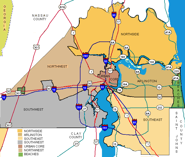
There are more than 500 neighborhoods within the area of Jacksonville, Florida, the largest city in the continental United States by area.[1] These include Downtown Jacksonville and surrounding neighborhoods.[2] Additionally, greater Jacksonville is traditionally divided into several major sections with amorphous boundaries: Northside, Westside, Southside, and Arlington, as well as the Jacksonville Beaches.[3]
There are four municipalities within Duval County which are outside of Jacksonville's city limits: Baldwin, Atlantic Beach, Neptune Beach, and Jacksonville Beach. The latter three communities, all located on a coastal barrier island, form part of the area known as the Jacksonville Beaches, together with Mayport within the Jacksonville city limits and Ponte Vedra Beach in St. Johns County.
Contents
Downtown
Downtown is the central business district of Jacksonville. The oldest section of the city, it is traditionally defined by the original boundaries of the city set upon its establishment. It is the center of Jacksonville's Urban Core, which includes the surrounding neighborhoods of LaVilla, Springfield, East Jacksonville, and Brooklyn, plus a section on the south side of the St. Johns River known as Southbank.
The area that became downtown Jacksonville was on the north bank of a crossing on the St. Johns River known as Wacca Pilatka to the Seminole and as the Cow Ford to the British. The land that became the town was largely drawn from two land grants from 1816, during Florida's Second Spanish Period: one to Maria Taylor, nee Suarez, and one to Juan LeMaestre. By 1821 a small community had grown there, and local residents plotted out the streets for a town, which they soon named "Jacksonville" after Andrew Jackson.[4]
The town was occupied by Union troops for much of the American Civil War, and steady growth came after the war's end, when it became one of Florida's first major tourist designations. In 1887 Jacksonville annexed several surrounding suburbs. Nearly all of downtown burned in the Great Fire of 1901; however a significant building boom followed immediately after.[4]
LaVilla
Main article: LaVillaLaVilla is a historic neighborhood located immediately west of Downtown. Jacksonville's first suburb, it was originally an independent city until it was annexed in 1887 along with several other suburbs. It included streets west of Clay Street and north of McCoy's Creek and the railroad lines. The part of LaVilla north of Adams Street was for many years a center of African-American life and culture in Jacksonville. Most residents were black, and the neighborhood contained many venues, such as the Ritz Theatre and the many clubs on the Ashley Street strip, which showcased black entertainers. The southern part of the neighborhood was a major railroad hub, with several rail lines meeting at Union Station (now the Prime F. Osborn III Convention Center), and probably not coincidentally, was also for a period Jacksonville's primary red light district.[5]
LaVilla was incorporated in the 1860s as a predominantly African-American town. Union troops were based in the area during the American Civil War. Along with five other suburbs, it was annexed by Jacksonville when the city limits expanded in 1887. The Great Fire of 1901 started in LaVilla, but the neighborhood was largely spared, while the fire ravaged downtown. Over the next several decades LaVilla saw the growth of a burgeoning music and entertainment scene, and many nationally renowned artists came to play at the local clubs on and off Ashely Street that catered to black audiences. In the 1960s, however, the neighborhood declined precipitously and has not recovered. The railroad industry declined and urban decay set in, and after the end of segregation many residents left to seek opportunities in other neighborhoods. In the 1980s began an urban renewal campaign that continues today.[5]
Brooklyn
Brooklyn is located south of LaVilla along the St. Johns River, immediately to the north of Riverside, Jacksonville, Florida. All of this area was plantation land until after the American Civil War, and changed hands a number of times during the 19th century. After the war it was acquired by Miles Price, who sold the southern half of the property to be developed as the suburb of Riverside. The northern section he retained and developed himself as Brooklyn.[5]
Brooklyn was initially a residential suburb, growing quickly with the establishment of a streetcar line. In 1887 Brooklyn and several other suburbs were annexed by Jacksonville. Brooklyn remained primarily residential into the 20th century, until it was rezoned for commercial use, and a number of commercial skyscrapers and other building were constructed along the river. In the late 20th and 21st century plans have been made to reintroduce residential zoning.[5]
Riverside and Avondale
Main articles: Riverside, Jacksonville, Florida and Avondale, Jacksonville, FloridaRiverside and Avondale are two adjacent and closely associated neighborhoods, alternately described as one continuous neighborhood, to the south of Downtown on the St. Johns River. Both neighborhoods are primarily residential, containing some of the city's most notable examples of residential architecture, with integrated business districts, including the historic Five Points area.[5]
The entire area south of Jacksonville was originally plantation land prior to the Civil War. After the war, a group of investors purchased the southern part of Miles Price's plantation to develop as a new residential suburb. Price retained the northern part of his land and developed it as the suburb of Brooklyn. Riverside and Brookyln were annexed by Jacksonville in 1887, but growth only boomed after the Great Fire of 1901, when many of the city's most prominent residents chose to rebuild their homes in Riverside. Growth continued through the early 20th century, resulting in one of the most varied architectural landscapes in Florida, including what is likely the largest collection of surviving bungalow houses in the state. In the late 1950s & 1960s, the area went into decay, with many of those grand old homes being converted into rooming houses. However, after being designated a "National Historic Neighborhood", by the late 1990s, Riverside had recovered, with many homes restored to their original form.
Avondale was developed later. In 1920 it was proposed as a new upscale development, the most expansive Jacksonville had ever experienced. Avondale is known for its quiet, tree-lined residential streets and hundreds of quaint homes, most dating from the early 1920s during the Great Florida Land Boom. A few Avondale homes pre-date 1900. Most homes in the neighborhood reflect the middle to upper income taste in residential architecture of the 1920s, including numerous Prairie School, Art Deco, Craftsman Style, Classical Revival, and Mediterranean Revival styles. Avondale is characterized by numerous bungalows and spacious, graceful homes. Unlike some other neighborhoods, Avondale never experienced a period of decline during the latter 20th century, and retains much of its original gentility.
Riverside and Avondale are routinely recognized as among the great neighborhoods in Jacksonville and Florida, and in 2010 they were named one of the top ten neighborhoods in the United States by American Planning Association.[6]
Springfield
Main article: Springfield, Jacksonville, FloridaSpringfield is a historic residential neighborhood located immediately north of Downtown. This area was originally part of the "Hogans' Donation", which was divided up following the Civil War for residential development. The original Springfield development dates to 1869; over time other developments were absorbed into a single community, all of which were annexed by Jacksonville in 1887. Springfield became home to many of Jacksonville's wealthiest residents, and boomed following the Great Fire of 1901, with many lavish houses being built. However, zoning changes in the late 1920s altered the residential character of the neighborhood, and the urban decay afflicting most of the United States' inner city neighborhoods since the mid 20th century sent Sprinfield into substantial decline. In 1975 a preservation society was formed with the intent of saving Springfield's architectural heritage, resulting in a resurgence of growth. According to author Wayne Wood, "Springfield is destined to re-emerge as one of Jacksonville's successful residential neighborhoods."[7][5]
Eastside
Eastside, or East Jacksonville, is a residential neighborhood located directly to the east of Downtown and Springfield. Unlike the areas known as Northside, Westside, and Southside, Eastside does not comprise a large section of Duval County. Eastside contains Jacksonville's sports complex, including EverBank Field, Jacksonville Veterans Memorial Arena, and the Baseball Grounds of Jacksonville.
The original East Jacksonville development was a small residential community located east of Jacksonville along the St. Johns River, which grew up shortly after the Civil War. Two other communities grew up around this time; Oakland and Fairfield. Oakland, located just north of East Jacksonville, was a working-class, largely African-American community. Fairfield was located farther east, along the northward bend of the river. Its attraction was as the location of Jacksonville's first Fairgrounds, which was the source of its name. These included a racetrack, the forerunner to Jacksonville's sports venues. Fairfield was incorporated as a city; in 1887 all three communities were among those annexed by Jacksonville. All three areas soon grew into one continuous neighborhood.[5]
Eastside has remained the center of Jacksonville's annual Fair and sports complexes, as well as a center of industry in the city. As with other inner city neighborhoods across the United States it underwent precipitous decline since the mid-20th century, though it has been the center of urban renewal projects.
San Marco
San Marco is a neighborhood south of Downtown Jacksonville, across the St. Johns River. Its origins are with the former city of South Jacksonville. Today, most of what was once the city of South Jacksonville is known as San Marco, while South Jacksonville or Southside is used for a much wider section of southern Duval County.
The area now comprising San Marco was occupied continuously long before what is now Downtown Jacksonville. It was the site of the ferry that crossed the Cowford, and was the site of plantations from the 18th century. After the Civil War these gave way to residential developments, including South Jacksonville, which came to absorb the other communities. South Jacksonville was incorporated as a city in 1907, and grew significantly following the construction of the original Acosta Bridge in 1921. In 1932 South Jacksonville was annexed by Jacksonville.[5]
The name San Marco comes from South Jacksonville's most ambitious development, begun in 1926 and consisting of many upscale Mediterranean Revival-style homes and an integrated commercial sector known as San Marco Square. Later, as South Jacksonville or Southside came to be applied to a wider and wider area of the city, San Marco has been applied to most of the area formerly a part of South Jacksonville. San Marco remains a diverse and architecturally significant neighborhood, with many of its former government buildings and homes surviving.[5]
St. Nicholas
St. Nicholas is a small neighborhood on the south side of the St. Johns River, just east of San Marco. Like San Marco it was inhabited long before the area now comprising Downtown. During Florida's Second Spanish Period, it was the site of Fort San Nicolas, which guarded the river crossing at the Cowford. This led to the area between the ferry and Miller's Creek being known as "San Nicolas". The name was later Anglicized to St. Nicholas).[5]
After the Civil War this area was the site of vacation and retirement homes for several wealthy Jacksonville residents. Some of their former homes remain in the area. Today St. Nicholas is a chiefly residential neighborhood with some commercial zoning along Beach and Atlantic Boulevards.[5]
Ortega
Main article: Ortega, Jacksonville, FloridaOrtega is located on the St. Johns River just south of Riverside and Avondale area. It lies on a peninsula jutting into the St. Johns River, separated from the mainland by the St. Johns River to the east and the smaller waterway known as the Ortega River to the north and west. It was formerly an island until a land bridge was constructed on the southern end; this now carries U.S. Route 17, or Roosevelt Boulevard. Ortega is one of the wealthiest neighborhoods in Jacksonville and one of the wealthiest in the United States; it was listed as the 46th wealthiest are in Worth magazine.[8]
Ortega is bisected by U.S. 17; the older area to the east of the road is known as "Old Ortega", while the area to the west is known as "Ortega Forest".[9] On July 14, 2004 a section of Ortega to the east of 17 and north of Verona Boulevard was designated as the Old Ortega Historic District by the National Register of Historic Districts. The history of the area includes a number of interesting characters: botanist William Bartram; highwayman and cattle rustler Daniel McGirtt; and Don Juan McQueen, who attempted to establish a plantation on his 1791 Ortega land grant, but was forced to leave due to attacks of Georgians and the French. Gangster George "Machine Gun" Kelly and his wife were rumored to be the mysterious couple who abruptly left their rented Grand Avenue home hours before a midnight police raid in 1933. Ortega is home to hundreds of mid-size to large, turn-of-the-century homes and Southern Style mansions. Many of these homes are situated directly on the river, and the nature of the "island" allows ease of access to the waterways for all residents. Along with Avondale and Riverside, Ortega is home to some of the wealthiest of Jacksonville families. It is marked by a distinctly traditional Southern culture complete with one of the South's most exclusive debutante coiteries. The island is almost exclusively residential, the only exception being a small square in the section known as "Old Ortega" on the northside where a small collection of restaurants, boutiques, and a pharmacy are found. Ortega, with its giant oaks, waterfront mansions, and series of parks is widely considered one of the most beautiful residential areas of Northeast Florida. Naval Air Station Jacksonville is also located on the southside of this neighborhood.[10]
Mandarin
Main article: Mandarin, FloridaMandarin is located on the east side of the St. Johns River just north of the border with St. Johns County. It was at one point a separate city, and was incorporated into Jacksonville in the Jacksonville Consolidation in 1968.[5]
Mandarin grew up as an orange grove farming community, and went by several names before receiving its current designation, picked for the Mandarin orange. After the Civil War was the summer home of author Harriett Beecher Stowe, whose book Palmetto Leaves was inspired by her experiences there. Mandarin remained a quiet community until 1970, when the construction of the Buckman Bridge, connecting Mandarin to Orange Park across the river, ushered in a new wave of development, and Mandarin subsequently became one of Jacksonville's fastest growing neighborhoods.[5]
Northside
Northside, or North Jacksonville, is one of the large sections of Jacksonville. It consists of neighborhoods north of Downtown, as well as large tract of largely undeveloped land north of the St. Johns River.[5] Northside neighborhoods include Biscayne, Biscayne Terrace, Black Hammock Island, Blount Island, Brown Island, The Cape, College Park, Copper Hill, Dames Point, Dinsmore, Durkeville, Duval, Eagle Bend, East Point, Forrest Trails, Fort George Island, Garden City, Hart Estates, Highlands, Hollyford, Imeson Park, Jax North Estates, Jamestown, Little Marsh Hill, New Berlin, North Creek, North New Berlin, North Lake, Oceanway, Pecan, Pumpkin, San Mateo, Turtle Creek and Yellow Bluff.
Panama Park
Panama Park is a neighborhood on Jacksonville's Northside. Grand Park is a neighborhood on Jacksonville's Northside.
Westside
Like Northside, Westside or West Jacksonville is one of the traditional large sections of Jacksonville. It refers to large section of Jacksonville west of Downtown and the interior neighborhoods, including both populated areas and a vast tract of undeveloped land.[5] Neighborhoods sometimes included as part of the Westside include Argyle, Avondale, Cedar Hills, Cedar Hills Estates, Chimney Lakes, Confederate Point, Duclay, Duclay Forest, Fairfax, Herlong, Hillcrest, Hyde Park, Jax Farms, Jacksonville Heights, Lake Shore, Maxville, McGirts Creek, Murray Hill, Normandy Manor, Normandy Village, Oak Hill, Ortega, Ortega Farms, Ortega Forest, Ortega Hills, Otis, Riverside, Rolling Hills, Settlers Landing, Sweetwater, Venetia, Wesconnett, Whitehouse, Yukon and West Jacksonville.[11][12]
Lake Shore
Lake Shore is a small neighborhood of southwest Jacksonville established in the 1920s.[13] It is defined by San Juan Avenue to the north, the Cedar River (called Cedar Creek by the locals) and US17/Roosevelt Boulevard to the east. The unique archways that mark the entrance to Bayview Road were restored and designated as historic landmarks by the Jacksonville Historic Preservation Commission in 2009.[14] The community is bisected by Florida State Road 21 (Blanding Boulevard), contiguous with the Jacksonville Marina Mile, and home to full service marinas, nautical outfitters and dry storage facilities.
Murray Hill
Murray Hill (Heights) in Jacksonville took the name of a neighborhood in Manhattan, New York City. Created in 1907, it was a replat from the Edgewood subdivision. The town of Murray Hill was incorporated in 1915 with its own mayor. The Lackawanna railroad terminal was located nearby, and many workers built homes there. The City of Jacksonville annexed the town on August 15, 1925.[15]
Arlington
Together with Northside, Westside, and Southside, Arlington is one of the large sections of Duval County. Initially, Arlington was a settlement to the east across the St. Johns River from Jacksonville; today it refers to most of Jacksonville east and south of the St. Johns, west of the Intracoastal Waterway, and north of the Arlington River Southside.[5]
Arlington was one of the first areas in the United States visited by Europeans; it was the site of the French Fort Caroline in 1564-1565, now represented by the Fort Caroline National Memorial. After the destruction of Fort Caroline, the area was only sparsely inhabited until the 19th century, when sawmills and plantations were established along the St. Johns River. After the American Civil War these gave way to residential developments, which were gradually absorbed into the Arlington community as it grew. The construction of the Matthews Bridge in 1953 opened the area up to significantly increased development, and over the next two decades Arlington became fastest growing part of the Jacksonville area.[5]
Sandalwood
The Sandalwood neighborhood began developing in the spring of 1960, midway between downtown Jacksonville and the beaches, or about 6 miles (9.7 km) from each, was advertised in 1960-61 as "On the Southside - halfway between business and pleasure!" The builder-developer, Pearce-Uible, was located at 3850 Beach Blvd.[16]
Southside
Southside, or South Jacksonville, is, along with Northside, Westside, and Arlington, one of the large sections of Jacksonville. It is generally said to include all land in Duval County east and south of the St. Johns River and south of Arlington, and west of the Intracoastal Waterway. It includes substantial residential developments and neighborhoods and some currently undeveloped land. Since the 1990s, it has been the fastest growing part of Jacksonville. Neighborhoods include Arrowhead, Avenues, Bayard, Baymeadows, Baymeadows Center, Beach Haven, Beauclerc, Bowden, Brackridge, Brierwood, Craven, Deercreek, Deerwood, Deerwood Center, Del Rio, Englewood, Goodbys Creek, Greenfield Manor, Greenland, Isle of Palms, Julington Creek, Kilarney Shores, Lakewood, Loretto, Mandarin, Mandarin Station, Miramar, Montclair, Pickwick Park, Pine Forrest, Royal Lakes, San Jose, San Jose Forrest, San Marco, Sans Pareil, Sans Souci, Secret Cove, South Riverside, Southpoint, Southwood, Spring Park, Sunbeam, Tiger Hole and Windy Hill.
Jacksonville Beaches
The Jacksonville Beaches are a group of towns and communities along the Atlantic Ocean. They are, from north to south, Mayport, Atlantic Beach, Neptune Beach, Jacksonville Beach, and Ponte Vedra Beach. The first four communities are located within Duval County; Atlantic Beach, Neptune Beach, and Jacksonville Beach are incorporated cities that maintain their own municipal governments.
Notes
- ^ "Citizens Planning Advisory Committee (CPACs)". coj.net. http://www.coj.net/Departments/Housing+and+Neighborhoods/Community+Development/CPACs/default.htm. Retrieved November 3, 2010.
- ^ Wood, Wayne (1992). Jacksonville's Architectural Heritgae. University Press of Florida. pp. 4–5. ISBN 0813009537.
- ^ McEwen, John W. (2007). "The Vernacular Neighborhoods of Jacksonville, Florida: Can GIS Help Determine their Boundaries?" The Florida Geographer, Vol. 38: 54-71.
- ^ a b Wood, Wayne (1992). Jacksonville's Architectural Heritgae. University Press of Florida. pp. 22–29. ISBN 0813009537.
- ^ a b c d e f g h i j k l m n o p q Wood 1992
- ^ Gibbons, Timothy J. (October 12, 2010). "Riverside-Avondale named one of 10 great neighborhoods in the nation". The Florida Times-Union. http://jacksonville.com/news/metro/2010-10-12/story/riverside-avondale-selected-nations-top-10-neighborhoods. Retrieved June 6, 2011.
- ^ http://www.jaxhistory.com/springfield.htm
- ^ Carbone, Marisa; Sarah W. Reiss, John Finotti (2010). Insiders' Guide to Jacksonville, 3rd Edition. Globe Pequot. pp. 178–179. ISBN 0762750324. http://books.google.com/books?id=rlHWoqDYZHkC&printsec=frontcover&source=gbs_ge_summary_r&cad=0#v=onepage&q&f=false. Retrieved September 20, 2010.
- ^ "Exploring Ortega". metrojacksonville.com. February 14, 2008. http://www.metrojacksonville.com/article/2008-feb-exploring-ortega. Retrieved September 20, 2010.
- ^ "Suburban Jacksonville: Ortega Forest" Metro Jacksonville, June 24, 2010
- ^ ("What's so appealing about the Westside?" Florida Times Union, December 23, 2007
- ^ "Westside story" Florida Times-Union, June 10, 1999
- ^ "Feature Detail Report for: Lake Shore". USGS. http://geonames.usgs.gov/pls/gnispublic/f?p=gnispq:3:::NO::P3_FID:285278.
- ^ Lovejoy, Heather (February 7, 2009). "Welcome to Lake Shore again - thanks to a bit of restoration work". Florida Times Union. http://jacksonville.com/community/my_westside_sun/2009-02-07/story/welcome_to_lake_shore_again_thanks_to_a_bit_of_restoratio.
- ^ "Urban Neighborhoods: Murray Hill" MetroJacksonville, June 30, 2010
- ^ Conner, Deirdre:"Saving Arlington: What residents are doing to save it" Florida Times-Union, February 14, 2010
References
- McEwen, John W. (2007). "The Vernacular Neighborhoods of Jacksonville, Florida: Can GIS Help Determine their Boundaries?". The Florida Geographer 38: 54–71.
- Wood, Wayne (1992). Jacksonville's Architectural Heritage. University Press of Florida. ISBN 0813009537.
External links
Neighborhoods of Jacksonville Arlington • Avondale • Jacksonville Beaches • Brooklyn • Downtown • Eastside • LaVilla • Mandarin • Murray Hill • Northside • Ortega • Riverside • San Marco • Southside • Springfield • St. Nicholas • WestsideJacksonville Attractions • Businesses • Education • Government • Famous Jacksonvillians • Flag • History • Gator Bowl • Mayors • Media • Metropolitan Area • Neighborhoods • Non-profit organizations •Parks • Skyscrapers • Sports • Transportation Categories:
- Neighborhoods in Jacksonville, Florida
- Lists of neighborhoods in U.S. cities
- History of Jacksonville, Florida
Wikimedia Foundation. 2010.