- Misasa, Tottori
-
Misasa
三朝町— Town — Location of Misasa in Tottori Prefecture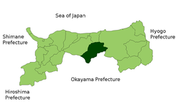

 Misasa
Coordinates: 35°25′N 133°52′E / 35.417°N 133.867°ECoordinates: 35°25′N 133°52′E / 35.417°N 133.867°E Country Japan Region Chūgoku Prefecture Tottori Prefecture District Tōhaku District Area - Total 233.46 km2 (90.1 sq mi) Population (October 1, 2007) - Total 7,322 - Density 31.4/km2 (81.3/sq mi) Time zone Japan Standard Time (UTC+9) City symbols - Tree Aesculus - Flower Rhododendron Phone number 0858-43-1111 Address 999-2 Ōaza Ōze, Misasa-chō, Tottori-ken
682-0195Website Town of Misasa 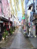 A street in the center of Misasa shortly before the Marie Curie festival
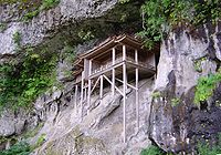 Sanbutsu-ji
Misasa (三朝町 Misasa-chō) is a town located in Tōhaku District, Tottori, Japan. It is also home to the official treasure of Sanbutsuji and the Okayama Hospital.
The name "Misasa" (literally "three mornings") originates from the belief that one who stays to enjoy three mornings in the town's famous hot springs will find all of his ailments cured.
As of October 1, 2007, the town has an estimated population of 7,322 and a density of 31.4 persons per km². The total area is 233.46 km². It is the second largest town in the prefecture (7th largest out of towns and cities).
Misasa is for the most part a spa resort, boasting springs of radium-rich water, exhausting radon, a radioactive gas. It is believed that bathing one in such waters can actually be good for one's health, though there is not a scientific consensus on whether doing so is actually detrimental or helpful to one's health (see Radiation hormesis). For this reason, the town of Misasa organizes a yearly Marie Curie festival – Marie Curie discovered radium.
The film Koitanibashi was shot in Misasa.[1]
Contents
Education
- Primary Schools
- Nishi Elementary School
- Higashi Elementary School
- Minami Elementary School
- Junior High Schools
- Misasa Junior High School
- Universities
- Institute for Study of the Earth's Interior, Okayama University
Neighboring municipalities
Places of note
- Misasa Onsen
- A radium-rich hot spring.
- Oshika Valley
- It is named a special location, or "meishou" (名所) by the government, and is about 4 km long.
- Sanbutsu-ji (temple)
- Located on the side of a cliff, it is one of the National Treasures of Japan.
References
- ^ HPriest (2011-11-12). "SPEED’s Uehara Takako attends stage greeting for “Koitanibashi”". TokyoHive. http://www.tokyohive.com/2011/11/speeds-uehara-takako-attends-stage-greeting-for-koitanibashi/. Retrieved 2011-11-13.
External links
 Media related to Misasa, Tottori at Wikimedia Commons
- (English) Official town website
- (Japanese) Official town website
- (French) Misasacho's blog from Official town website – French and English posts
Categories:- Towns in Tottori Prefecture
- Tōhaku District, Tottori
- Tottori geography stubs
- Primary Schools


Wikimedia Foundation. 2010.