- Maniwa, Okayama
-
Maniwa
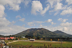
真庭市— City — View of Hiruzen Plateau
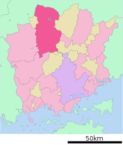
FlagLocation of Maniwa in Okayama Coordinates: 35°5′N 133°41′E / 35.083°N 133.683°ECoordinates: 35°5′N 133°41′E / 35.083°N 133.683°E Country Japan Region Chūgoku (Sanyo) Prefecture Okayama Government - Mayor Koichiro Ide (since April 2005) Area - Total 828.43 km2 (319.9 sq mi) Population (September 1, 2011) - Total 50,389 - Density 60.8/km2 (157.5/sq mi) Time zone Japan Standard Time (UTC+9) Phone number 0867-44-2611 Address 53-1 Katsuyama, Maniwa-shi, Okayama-ken
717-0013Website City of Maniwa Maniwa (真庭市 Maniwa-shi) is a city in Okayama Prefecture, Japan.
On 31 March 2005, the town of Hokubō (from Jōbō District); the towns of Katsuyama, Ochiai, Yubara, and Kuse and the villages of Mikamo, Kawakami, Yatsuka, and Chūka (from Maniwa District) merged to form the new city of Maniwa.
On September 1, 2011, Maniwa had an area of 828.43 km², the largest area of any municipality in the prefecture. Its population was 50,389, with 17,711 households.
External links
 Media related to Maniwa, Okayama at Wikimedia Commons
- Maniwa official website (Japanese)
Categories:- Cities in Okayama Prefecture
- Okayama geography stubs
Wikimedia Foundation. 2010.


