- Pelmo Park-Humberlea
Infobox City
official_name = Pelmo Park-Humberlea
subdivision_type2 = Country
subdivision_name2 =Canada
subdivision_type1 = Province
subdivision_name1 =Ontario
subdivision_type = City
subdivision_name =Toronto 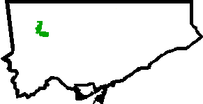
mapsize=150px
map_caption=Location of Pelmo Park-Humberlea within TorontoPelmo Park-Humberlea is a neighbourhood of in the North York area of
Toronto ,Ontario ,Canada . Like its name implies, it is composed of two geographic areas, the first being the Pelmo Park area which is bordered by the 401 to the north, Woodward Avenue to the south, Jane Street to the east and the Canadian Pacific Railway to the west.http://www.toronto.ca/demographics/images/pelmo_park_humberlea.jpg]The second area, Humberlea, is bordered by Sheppard Avenue west to the north, Oak Street to the south, the Canadian Pacific Railway to the east and the Humber River to the west.
Many of the neighbourhoods in this quadrant of the city can aptly be described as family neighbourhoods with access to parks, green space and a slower pace than found closer to
downtown .There is a large Italian population living in this north end neighbourhood.
History
this section needs expansion
Today
this section needs expansion
Public Transportation
Pelmo Park-Humberlea is served by the
Toronto Transit Commission .PUBLIC TRANSIT ACCESSIBILITY FOR THE DISABLED:
As of June 2007 [http://www.toronto.ca/ttc/pdf/accessmap0706.pdf] , the 35 Jane, 96 Wilson, 165 Weston RD North & the 84 Sheppard West are accessible.
Parkland & Recreation
this section needs expansion
See also
*Humber River
*Weston Road
*Albion Road (Toronto)
*Black Creek Drive
*Humber River Regional Hospital References
External links
* http://www.toronto.ca/demographics/cns_profiles/cns23.htm
* http://www.torontohistory.org/Pages_VWXYZ/Wallace_C_Swanek.html
* http://www.toronto.ca/legdocs/agendas/council/cc/cc980304/ny2rpt/cl014.htm
* http://www.torontorealestateboard.com/about_TO/Neighbourhood/regions/northyork/111.htmlToronto Neighbourhood Geography
North =Humbermede
East =Downsview-Roding-CFB , Rustic
South = Weston
West = Kingsview Village-The Westway, Elms-Old Rexdale
Center = Pelmo Park-Humberlea
Wikimedia Foundation. 2010.