- Nilma, Victoria
-
Nilma
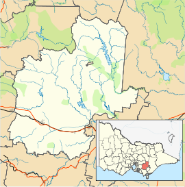
VictoriaPopulation: 218 (2006)[1] Postcode: 3821 Location: LGA: Shire of Baw Baw State District: Narracan Federal Division: McMillan Localities around Nilma: Warragul Nilma North Nilma North Warragul Nilma Nilma North Warragul Bull Swamp Darnum Nilma is a small town in the West Gippsland region of Victoria, Australia located between Warragul and Darnum. At the 2006 census Nilma had a population of 218.
The Post Office opened on 1 May 1886 as Bloomfield Railway Station, was renamed Nilma in 1909 and closed in 1979.[2]
The town in conjunction with neighbouring township Darnum has an Australian Rules football team competing in the Ellinbank & District Football League.[3]
References
- ^ Australian Bureau of Statistics (25 October 2007). "Nilma (State Suburb)". 2006 Census QuickStats. http://www.censusdata.abs.gov.au/ABSNavigation/prenav/LocationSearch?collection=Census&period=2006&areacode=SSC26349&producttype=QuickStats&breadcrumb=PL&action=401. Retrieved 2007-10-01.
- ^ Premier Postal History, Post Office List, https://www.premierpostal.com/cgi-bin/wsProd.sh/Viewpocdwrapper.p?SortBy=VIC&country=, retrieved 2008-04-11
- ^ Full Points Footy, Nilma Darnum, http://www.fullpointsfooty.net/Nilma_Darnum.htm, retrieved 2008-07-25[dead link]
Places in Shire of Baw Baw Aberfeldy • Athlone • Buln Buln • Darnum • Drouin • Erica • Fumina South • Hill End • Icy Creek • Jindivick • Longwarry • Neerim • Neerim North • Neerim South • Nilma • Noojee • Parkers Corner • Rawson • Rokeby • Tanjil Bren • Thorpdale • Trafalgar • Walhalla • Warragul • Willow Grove • Yarragon •
Coordinates: 38°11′S 145°58′E / 38.183°S 145.967°E

This article about a location in Gippsland is a stub. You can help Wikipedia by expanding it.

