- Walhalla, Victoria
Infobox Australian Place | type = town
name = Walhalla
state = vic
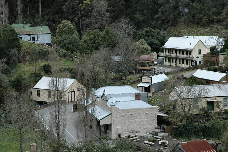
caption = View of part of Walhalla, showing mainly original buildings, including the fire station built over the creek, as well as some reconstructed ones
lga =Shire of Baw Baw
postcode = 3825
est =
pop = 10
elevation=
maxtemp =
mintemp =
rainfall =
stategov = Narracan
fedgov = McMillan
dist1 = 182
dir1 = E
location1=Melbourne
dist2 = 49
dir2 = NE
location2= MoeWalhalla is a small town in Victoria,
Australia , founded as a gold-mining community in early 1863 and at its peak home to around 3,000 residents. Today, the town has a population of less than 20 permanent residents, though it attracts large numbers of tourists and is a major focus of the regional tourism industry. The town's name is taken from an early gold mine in the area, named for the German hall of fame, theWalhalla temple (Valhalla from Norse legend).Geography
Walhalla is located in South-East
Australia , in the eastern Victorian region ofGippsland , about 180 kilometres from the state capitalMelbourne . It is located in theGreat Dividing Range , in the steep Stringer's Creek valley, approximately six kilometres upstream of the creek's junction with the Thomson River. The area around the town is designated as an historic area, adjoining theBaw Baw National Park .Owing to the confined space in which the town finds itself, the majority of buildings are located along one main street which follows the creek through the valley until it splits into two branches at the northern end of the town centre. In the late nineteenth century the town also sported a number of suburbs, situated on the mountain peaks above the valley.
History
Discovery of Gold
The history of Walhalla is closely linked to the history of gold in Victoria. The first gold had been found in Victoria in 1851, leading to the
Victorian gold rush . By 1859 prospectors had pushed far east of Melbourne into the trackless wilderness of theGreat Dividing Range . Major gold strikes on the Jordan River encouraged other prospectors to follow the nearby Thomson River in their search for the valuable metal.A group of prospectors who had been exploring in creeks flowing into the Thomson River valley found gold sometime during late December 1862 or early January 1863. A claim was pegged out and a member of this group, former
convict Edward Randel, registered the claim at the outpost town on Bald Hills on 12 January under his assumed name, Edward "Ned" Stringer. Although he was presented with a monetary reward of £100 for his discovery, Stringer was unable to capitalise on his finds, dying in September 1863. Although the settlement was soon rechristened Walhalla after an early mine, the creek running through town still bears his name.The rush that inevitably followed news of this find was slowed to some extent by the goldfield's remote and inaccessible location, but many miners soon found their way there. In February 1863, John Hinchcliffe discovered an immensely rich quartz reef in the hill just above the creek, which he named Cohen's Reef, after a storekeeper at Bald Hills.
Mining Operations
Gold panning and related techniques quickly exhausted all the alluvial (surface) deposits. By late 1863 mining operations began as prospectors sought and then followed the underground veins of gold. At Walhalla this could mean tunnelling "into" the steep valley walls as well as the more traditional digging downward.
The vast majority of gold extraction from Walhalla centred around Cohen's mine, the largest single mine in Victoria. By 1900 the mine had already produced around 55 tonnes of gold (approximately 1.8 million troy ounces, worth around US$790 million in 2005).
Due to the enormous expenses of underground gold mining, small claims operated by individuals or small groups soon folded, being replaced by large companies such as the Long Tunnel Mining Company. This company owned the richest mine working the reef, the Long Tunnel, which produced around 13.7 tonnes of gold alone over its operation between the years 1865-1914.
The crushing machinery used to extract the gold from the quartz-based ore required large amounts of energy, supplied largely by wood-burning steam engines. The need for fuel wood led to the hills being denuded for some considerable distance around town, timber tramways bringing freshly-cut timber for the boilers. The associated costs of bringing wood from further and further away were a key factor in the economic problems which eventually ended mining in Walhalla.
Walhalla's Boom Period (1860-1910)
By late 1863 there had been more finds made nearby at Happy-Go-Lucky, three kilometres from Stringer's Creek, and at Cooper's Creek, where copper was later to be discovered in even greater abundance. By March 1864, Walhalla had a weekly mail service from Toongabbie, and the Walhalla Post Office was opened on 22 August 1864 (known as Stringer's Creek until 1868).Citation
last = Premier Postal History | title = Post Office List | url = https://www.premierpostal.com/cgi-bin/wsProd.sh/Viewpocdwrapper.p?SortBy=VIC&country= | accessdate = 2008-04-11 ]
The first hotel, the "Reefer's Arms", was opened in September 1863. In time, there were more than a dozen hotels, breweries and an aerated waters factory. A branch of the Bank of Victoria was opened in September 1865, and a branch of the Bank of Australasia was opened in February 1866. Shopkeepers, publicans and other traders built the town up quickly in support of the rush.
By May 1866, the township of Stringer's Creek had been surveyed and renamed Walhalla, after one of the most prosperous mines then working. Most of the first lots of township land were sold to the already-resident householders. That year saw a church building was erected for the
Wesleyan Church , and establishment of a Police reserve and Court of Petty Sessions.The growing number of families in the area saw the
Mechanics' Institute and Free Library also serving as a school when it opened in 1867. Before long, Walhalla could boast fraternal societies, a debating club, and (briefly at least) a chess club, choral union and dramatic club. By January 1870, the "Walhalla Chronicle" newspaper was being published, and by December of the same year, a two-acre (.8 ha) site had been gazetted for State School No. 957, which had taken its first enrolments in 1868.A self-appointed "Council of Ten" sought registration as a Borough in 1869, but dissolved without the necessary public support for rating the town's properties before it could accomplish much more than commissioning the construction of the stone retaining wall that still stands today in the centre of town. A Borough was eventually proclaimed in late 1872, and by 1878 was able to successfully agitate with the state government for the completion of the first section of the present main road from Moe. By the end of 1879, Walhalla had daily coach services connecting it to the railway line at Moe to the south and to Traralgon to the east, and its isolation had been considerably reduced.
The Long Tunnel Company introduced both electricity (1884) and the telephone (1891) into the mine. Although Walhalla briefly led the world in having two electric street lights in 1884, this service was never extended further into the town. But the community continued to grow, with houses and gardens lining the hillsides along the valley, to a peak population of more than 2,000 with more than that many again living in the surrounding mountain-top "suburbs" of Maiden Town, Mormon Town and Happy Go Lucky. Sporting activities such as cricket and football clubs, with a cricket ground being created through levelling the top of a nearby hill as no other flat land was available.
The End of Mining and years as Ghost Town (1910-80)
After many years of lobbying from business interests, the Victorian government eventually agreed to the construction of a rail line into town. The line was completed into Walhalla in 1910, the last of four narrow gauge (2' 6") railways built by the
Victorian Railways . The small tank engines which operated were2-6-2 , the same class as those used on theWangaratta narrow gauge. Some are preserved and operated byPuffing Billy Railway near Melbourne. Branching from the main Gippsland line at Moe, the Walhalla line crossed hilly farming country, until it reached the town of Erica where it entered heavily mountainous territory, crossing the Thomson River by means of a large steel and concrete bridge then snaking up Stringer's Creek Gorge over a track featuring ledges blasted from sheer rock faces, dry stone walls built rising from the creek bed, and six timber trestle bridges and brackets within the last few hundred metres into town.It was hoped that the railway would bring new life back into the community, however gold mining was already becoming largely unprofitable and the last of the major mines closed in 1914. With the disappearance of the main industry in town, the bulk of the population soon left.
One of the railway's main uses became the removal of old buildings out of town, with the original railway station being relocated in the late 1930s to Hartwell in suburban Melbourne. In 1944 the section from Platina to Walhalla was closed, with the small copper and lime producing settlement of Coopers Creek using Platina as a supply point until the section of line between Platina & Erica closed in 1952. The service from Moe to Erica continued to service the farming and timber industries of the area, but it gradually decreased in patronage, until it too was closed in 1954.
Until the growth of the tourist industry in the 1970s and 80s, Walhalla continued on as a ghost town for most of the twentieth century. Several major public buildings including the Mechanics Institute and Star Hotel were destroyed in two fire events in 1944 and 1951 and a number of buildings were destroyed without being rebuilt. The school closed in 1965 and further fires and floods slowly chipped away at the remains of the town.
Walhalla in the present day
Since around 1980 Walhalla has experienced something of a renaissance with a booming tourist industry and the restoration or reconstruction of numerous historical buildings in the town, including the Star Hotel, Mechanics Institute and reconstruction of the Thomson-Walhalla section of the former narrow gauge railway.
In 1991 a group of interested parties formed a taskforce to investigate reconstruction of the Walhalla railway as a tourist attraction, something which had been unsuccessfully attempted on at least one other occasion previously. Work by the newly-formed
Walhalla Goldfields Railway commenced in 1993 at Thomson Station, situated next to the Thomson River immediately before the bridge. With the restoration of the Thomson River Bridge, trains began to take tourists back up the Stringer's Creek Gorge, with a temporary terminus being created at Happy Creek due to the need for reconstruction of the timber trestle bridges completing the journey into town.This terminus was the end point for tourist trains from Thomson Bridge from 1996 until 2002, when the line was opened through to the old station site. The current station building is an exact replica of the original, although the yard layout is considerably different owing to a section of the former station's location having been covered by earlier road deviation works of the main road into Walhalla.
In December 1998, Walhalla became the last mainland community in Australia to be connected to the electricity grid, [ [http://www.walhalla.org.au/news/power.htm|"Historic Walhalla" Website] ] although some other towns don't have electricity yet, such as Licola nearby.
Landmarks and tourist information
As well as historical buildings, the township features many mines and mineshafts and the mountainous terrain is popular with hikers and bushwalkers. It is the starting point for the 650 km
Australian Alps Walking Track , which continues to near Canberra. Walhalla also features many camping grounds, although camping is not permitted within 50 m of Stringers Creek, as the water is not fit for drinking.The current railway station is an exact replica built to the original Victorian Railways plans of the original station building (now located in the Melbourne suburb of Hartwell), although the interior is different to the original configaration.It is situated on the opposite side of the station yard from its original location due to the main road into Walhalla having been widened after the railway closed. Train rides are operated by the
Walhalla Goldfields Railway over the restored section between Walhalla and the Thomson River.The Walhalla Fire Station was built straddling Stringers Creek and is now open to the public as a museum.
The Band Rotunda was built at the junction of the left- and right-hand branches of Stringers Creek in 1896, commissioned by the Mountaineer
Brass Band , who held a competition for its design. Two hotels were situated opposite the Band Rotunda, the "Star Hotel" on the north side of the creek fork, and the "Grand Junction Hotel" on the south side. The original "Star Hotel" was burnt down in a bushfire in 1952, but reconstructed in 1999 with a recreation of the original facade.Windsor House was built by German Johannes Gloz between 1878 and 1888 from around 90,000 handmade bricks, the only brick residence in the town. Gloz maintained a vineyard on the slope above building, producing around 900 bottles of Riesling in the year 1880. The building is currently a
bed and breakfast .Situated on top of the hill immediately to the north-east of the junction of the east and west branches of Stringers Creek is the
Walhalla Cricket Ground , approximately a 45-minute hike from the valley floor.The Long Tunnel Extended Gold Mine
The Long Tunnel Extended Gold mine is owned by the Government of Victoria and is operated by the Walhalla Crown Reserves Board of Management on behalf of the people of Victoria. Underground tours are conducted daily. The tour takes visitors 300 metres into the huge underground machinery chamber hewn from the solid rock over a century ago. Old mining methods are discussed and a large outcrop of the famous Cohens Line of Reef is exposed in the mine.
References
*James, G.F. & Lee, C.G. "Walhalla Heyday", Graham Publications, Ringwood, 1970. ISBN 0-9596311-3-5 (a comprehensive pictorial and articles on the old gold town)
*Kiely, John and Savage, Russell, "Steam on the Lens: Walhalla Railway Construction, the photographs of Wilf Henty; Vol. 11", Russel Savage, Mildura, 2002, ISBN 0-9581266-0-7 (a second volume pictorial of the construction of the railway into Walhalla during 1908-10. Images taken from large glass negatives)
*Paull, Raymond (new edition, 1980) "Old Walhalla: Portrait of a Gold Town", Carlton, Vic: Melbourne University Press, ISBN 0-5228421-2-7
*'The Ghosts of Walhalla', song by
Weddings Parties Anything External links
* [http://www.walhalla.org.au Walhalla Heritage and Development League]
* [http://www.walhallarail.com Walhalla Goldfields Railway]
* [http://www.walhallaboard.org.au Walhalla Board of Management Inc.]
Wikimedia Foundation. 2010.