- Muckle Roe
-
Muckle Roe Location Muckle Roe shown within Scotland OS grid reference HU317650 Names Norse name Mikla Rauðey Meaning of name Old Norse for "big red island" Area and summit Area 1,773 hectares (6.8 sq mi) Area rank 37 Highest elevation Mid Ward 172 metres (564 ft) Population Population 104 Population rank 45 out of 97 Main settlement Roesound Groupings Island group Shetland Local Authority Shetland Islands 

References [1][2][3][4][5] If shown, area and population ranks are for all Scottish islands and all inhabited Scottish islands respectively. Population data is from 2001 census. Muckle Roe is an island in Shetland, Scotland, in Saint Magnus Bay, to the west of Mainland, Shetland. It has a population of around 100 people, who mainly croft and live in the south east of the island.[2][5] It is not near Little Roe.
Contents
History
The island is referred to in the Orkneyinga saga.[6]
In 1905, a bridge was built between Muckle Roe, and the Shetland Mainland, over Roe Sound.[5]
Geography and geology
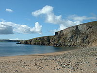
Muckle Roe is approximately 3 miles (4.8 km) in diameter, with high cliffs in the south. Its highest point is Mid Ward 172 metres (564 ft).
The island's rock is red granite,[2] and the dominant feature is an ancient extinct volcano, which gives the island its name - Old Norse for "Big Red Island".[2][5]
There are crofts in the east and south east. The rest of the island is lochan-studded moorland.[7]
Population
Year Number of Inhabitants 1851 2901871 2161881 2301961 1031971 941981 1011991 1152001 104References
- ^ 2001 UK Census per List of islands of Scotland
- ^ a b c d Haswell-Smith, Hamish (2004). The Scottish Islands. Edinburgh: Canongate. ISBN 1841954543.
- ^ Ordnance Survey. Get-a-map (Map). http://www.ordnancesurvey.co.uk/oswebsite/getamap/.
- ^ Fraser, Allen (2002) The Edinburgh Geologist: Old Norse and Norn names in Shetland. Issue 39 Retrieved 14 April 2007.
- ^ a b c d Keay, J. & Keay, J. (1994) Collins Encyclopaedia of Scotland. London. HarperCollins.
- ^ Anderson, Joseph (Ed.) (1893) Orkneyinga Saga. Translated by Jón A. Hjaltalin & Gilbert Goudie. Edinburgh. James Thin and Mercat Press (1990 reprint). ISBN 0-901824-25-9
- ^ "Overview of Muckle Roe". Gazetteer for Scotland. http://www.scottish-places.info/features/featurefirst1102.html. Retrieved 2008-01-06.
Shetland Inhabited islands 
Other islands Balta · Bigga · Brother Isle · Colsay · Hascosay · Hildasay · Lamba · Linga, Muckle Roe · Linga, Yell · Mousa · Noss · Oxna · Papa · Papa Little · Samphrey · South Havra · Uyea, Northmavine · Uyea, Unst · Vementry · West Linga
Towns and villages Maritime features Extreme points
(N · S · E · W)Topics Animal breeds · Etymology · History · Prehistory ·
Islands of Scotland Northern Isles 
Hebrides Other Coordinates: 60°22′N 1°25.5′W / 60.367°N 1.425°W
Categories:- Islands of Shetland
- Shetland geography stubs
Wikimedia Foundation. 2010.


