- Kananaskis, Alberta
Infobox Settlement
official_name = Kananaskis
other_name =
native_name =
nickname =
settlement_type = Improvement district
motto =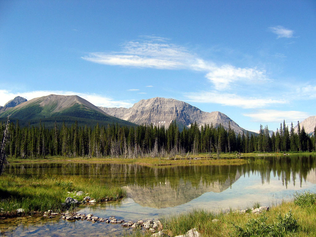
imagesize =
image_caption = Kananaskis Country
flag_size =
image_
seal_size =
image_shield =
shield_size =
city_logo =
citylogo_size =
mapsize =
map_caption =
mapsize1 =
map_caption1 =
image_dot_
dot_mapsize = 250px
dot_map_caption = Location of Kananaskis inAlberta
dot_x = 117 |dot_y = 257
pushpin_
pushpin_label_position =
pushpin_map_caption =
pushpin_mapsize =
subdivision_type = Country
subdivision_name = CAN
subdivision_type1 = Province
subdivision_name1 = AB
subdivision_type2 = Region
subdivision_name2 =Alberta's Rockies Calgary Region
subdivision_type3 = Census division
subdivision_name3 = No. 15
subdivision_type4 =
subdivision_name4 =
government_footnotes =Cite web| url= http://kananaskisid.ca/councilrole.php| title= Council| author= Kananaskis|accessdate= 2007-07-09]
government_type =
leader_title = Governing body
leader_name = AB Municipal Affairs
leader_title1 =
leader_name1 = Kananaskis Council
leader_title2 = Chair
leader_name2 = Linda McNeely
leader_title3 = District seat
leader_name3 =Kananaskis
leader_title4 =
leader_name4 =
established_title = Established
established_date = 1983
established_title2 =
established_date2 =
established_title3 =
established_date3 =
area_magnitude =
unit_pref =
area_footnotes =
area_total_km2 = 4211
area_land_km2 =
area_water_km2 =
area_total_sq_mi =
area_land_sq_mi =
area_water_sq_mi =
area_water_percent =
area_urban_km2 =
area_urban_sq_mi =
area_metro_km2 =
area_metro_sq_mi =
area_blank1_title =
area_blank1_km2 =
area_blank1_sq_mi =
population_as_of = 2006
population_footnotes =
population_note =
population_total = 429
population_density_km2 = 0.1
population_density_sq_mi =
population_metro =
population_density_metro_km2 =
population_density_metro_sq_mi =
population_urban =
population_density_urban_km2 =
population_density_urban_sq_mi =
population_blank1_title = Dwellings
population_blank1 = 183
population_density_blank1_km2 =
population_density_blank1_sq_mi =
timezone = MST
utc_offset = -7
timezone_DST =
utc_offset_DST =
latd= 51|latm= 04|lats= 32|latNS=N
longd= 115|longm= 07|longs= 51|longEW=W
elevation_footnotes =
elevation_m =
elevation_ft =
postal_code_type =
postal_code =
area_code =
blank_name =
blank_info =
blank1_name =
blank1_info =
website = [http://kananaskisid.ca/ Kananaskis]
footnotes = Kananaskis is an improvement district (a type of rural municipal administrative unit) situated to the west ofCalgary, Alberta ,Canada in thefoothills and front ranges of theCanadian Rockies .Located within the improvement district is Kananaskis Country, a km2 to mi2|4211 tract of land with spectacular mountain and foothills scenery. 66-km long section of Highway 40 (this segment also called Kananaskis Trail) runs through the area. An ecological and environmental research station of the
University of Calgary is located nearby, atBarrier Lake . A "Tim Horton Children's Foundation" summer camp is also located in the area.Easter Seals Camp Horizon is also located within Kananaskis.Recreation and tourism
Recreation and tourism is what Kananaskis Country is noted for. Development for recreation in Kananaskis includes several campgrounds, a
golf course, some hotels, a holiday ranch, two alpine ski areas (Nakiska , which hosted alpine skiing and freestyle moguls skiing during the1988 Winter Olympics andFortress Mountain ) and a competitive cross-country ski area (the Canmore Nordic Centre) that the public can use. The Canmore Nordic Centre was the venue for cross-country skiing events during the1988 Winter Olympics . Most of the development is within Peter Lougheed Provincial Park and along the highway 40 corridor that parallels theKananaskis River . Kananaskis has many kilometres ofhiking , cross-country ski, and horse trails. Other activities popular in Kananaskis includemountain biking ,scrambling ,climbing , backpacking,hunting , andfishing .Parks
Several parks and one ecological reserve are located within Kananaskis. These include:
*Bluerock Wildland Provincial Park
*Bow Valley Provincial Park
*Bow Valley Wildland Provincial Park
*Bragg Creek Provincial Park
*Canmore Nordic Centre Provincial Park
*Don Getty Wildland Provincial Park
*Elbow-Sheep Wildland Provincial Park
*Peter Lougheed Provincial Park
*Plateau Mountain Ecological Reserve
*Sheep River Provincial Park
*Spray Valley Provincial Park Special areas within Kananaskis Country that are not formally designated as parks or ecological reserves include the Bow Corridor Area, the
Elbow River Valley Area, Evan-Thomas Provincial Recreation Area, the Highwood/Cataract Areas, Sentinel Provincial Recreation Area, Stoney Creek Provincial Recreation Area, Strawberry Provincial Recreation Area and the Sibbald Area (Sibbald Lake Provincial Recreation Area, Sibbald Meadows Pond Provincial Recreation Area).Administration
On a provincial level, Kananaskis Country has been administered since 1945 as Improvement District No. 5 (Kananaskis) [ [http://www.municipalaffairs.gov.ab.ca/cfml/profiles/data/0373_1.htm Kananaskis Improvement District] - Alberta Municipal Affairs] . It was established by the Municipal Affairs branch of the
Alberta Government for multiple uses including timber harvesting, gas and oil extraction,cattle grazing,recreation andtourism . All activities are planned and facilities are developed with watershed protection as a priority. Not all areas of Kananaskis Country are covered by the same measure of protection. Areas within Kananaskis Country include Provincial Parks, Provincial Recreation Areas, Wildland Provincial Parks, and Ecological Reserves. All of the aforementioned categories are governed by differing laws.A management plan approved in March 2003 by the Kananaskis Country restricts further development in the
Spray Valley Provincial Park area, in order to preserve the ecological integrity. Restrictions were imposed on off-road vehicles, snowmobiles,horseback riding andbiking , however a site in the Spray Valley is considered for the construction of a small lodge [FFWD article (August 2003). [http://www.ffwdweekly.com/Issues/2003/0814/news1.htm Kananaskis Country management plan pleases greens, irks others] . RetrievedMarch 11 , 2007] [Alberta Tourism, Parks, Recreation and Culture (2006). [http://www.cd.gov.ab.ca/enjoying_alberta/parks/featured/kananaskis/parks_spray.asp Management plans for the Kananaskis Area] . RetrievedMarch 11 , 2007] .Demographics
No incorporated communities are located in Kananaskis. In 2001 the Kananaskis improvement district had a population of 462 in 210 dwellings spread over an area of 4,211.22 km², a density of 0.1 inhabitants/km². [ [http://ceps.statcan.ca/english/Profil01/CP01/Details/Page.cfm?Lang=E&Geo1=CSD&Code1=4815013&Geo2=PR&Code2=48&Data=Count&SearchText=kananaskis&SearchType=Begins&SearchPR=01&B1=All&Custom= Kananaskis Community Profile] - Statistics Canada. 2002. 2001 Community Profiles. Released June 27, 2002. Last modified: 2005-11-30. Statistics Canada Catalogue no. 93F0053XIE]
In 2006, Kananaskis had a population of 429 living in 183 dwellings, a 7.1% decrease from 2001. The improvement district has a land area of km2 to mi2|4210.72|abbr=yes|wiki=yes and a
population density of Pop density km2 to mi2|0.1| spell=UK | abbr=yes.Cite web| url= http://www12.statcan.ca/english/census06/data/profiles/community/Details/Page.cfm?Lang=E&Geo1=CSD&Code1=4815013&Geo2=PR&Code2=48&Data=Count&SearchText=Kananaskis&SearchType=Begins&SearchPR=01&B1=All&GeoLevel=&GeoCode=4815013 | title= Kananaskis - Community Profile | author= Statistics Canada| authorlink= Statistics Canada| year= Census 2006 | accessdate= 2007-07-01]28th G8 Summit in Canada
In
June 26 andJune 27 ,2002 , the area hosted the 28th G8 Summit. This annual "Group of 8" Summit was held atKananaskis Resort (also called the "Delta Lodge at Kananaskis"). [Delta Hotels: [http://www.deltahotels.com/hotels/hotels.php?hotelId=30 Kananaskis Resort] ] This was the second time Canada used alodge venue for the G8 Summit, after its inaugural 7th G7 Summit atMontebello, Quebec in1981 , according to page 84 of this paper called "A Summit of Substantial Success:The Performance of the 2008 G8 [http://www.g8.utoronto.ca/scholar/kirton-performance-080717.pdf] ."Invited Non-G8 Participants
*flagicon|South Africa
South Africa
*flagicon|NigeriaNigeria
*flagicon|AlgeriaAlgeria
*flagicon|SenegalSenegal Invited International Organization
*flagicon|United Nations
United Nations So far, it is the only G8 Summit to be held in
Western Canada . The next Canadian and 36th G8 Summit will be held in2010 atHuntsville, Ontario . The 2002 conference pumped some $300-million into the Kananaskis andAlberta economy; however, security cost taxpayers in excess of $200-millionAndreatta, David. [http://www.theglobeandmail.com/servlet/story/RTGAM.20080711.whuntsville12/BNStory/Front/home "Brace yourself, Huntsville. The G8 is coming,"] "Globe and Mail" (Toronto). July 12, 2008.] , in light of theSeptember 11, 2001 attacks atNew York City , the Pentagon andShanksville, Pennsylvania in theUnited States .Photo gallery
ee also
*
The Canadian Rockies Trail Guide
*Scrambles in the Canadian Rockies
*Kananaskis Country Trail Guide
*List of Alberta provincial parks
* [http://www.foothillsguide.com THE FOOTHILLS GUIDE - Kananaskis Community/Regional Portal (Business Listings, Classifieds, & Events)]References
External links
* [http://www.cd.gov.ab.ca/enjoying_alberta/parks/featured/kananaskis/flashindex.asp Kananaskis Country]
* [http://kananaskisid.ca Kananaskis Improvement District]
* [http://hikealberta.com/hike/cat/kananaskis Hiking in Kananaskis]Canadian City Geographic Location (8-way)
Northwest =Banff National Park
North =

Wikimedia Foundation. 2010.