Millennium Coastal Path

Millennium Coastal Path
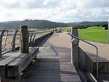
The Millennium Coastal Path at Llanelli.
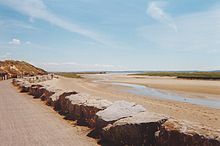
The Millennium Coastal Path at Pembrey.

The Millennium Coastal Path is a 22 km pedestrian walkway and cycleway along the south coast of Carmarthenshire, providing a link between Llanelli and Pembrey Country Park. The cycleway forms a section of both the Celtic Trail cycle route (part of NCN 47) and the National Cycle Network NCN 4.

The Millennium Coastal Path runs through the Millennium Coastal Park. It is a common mistake made mainly by locals in the Llanelli-Kidwelly area to confuse these names. More than 2,000 acres (8.1 km2) of industrial wasteland was remediated to construct the route.[1]

February 2007 storm damage

On the evening of Monday 19 February, a high tide combined with a high storm swell caused severe damage to a section of the path and cycle route near Burry Port. A 500m section was damaged with complete loss of a 150m section. The damage is expected to take many months to repair. A diversion is in place along the Burry Port relief road.

External links

Coordinates: 51°41′04″N 4°11′55″W / 51.6844°N 4.1985°W / 51.6844; -4.1985


Wikimedia Foundation. 2010.

Игры ⚽ Поможем написать реферат

Look at other dictionaries:

  • Millennium Coastal Park — Part of the Millennium Coastal Path at Llanelli The Millennium Coastal Park was originally a project undertaken by Llanelli Borough Council to transform a 20 km stretch of industrial wasteland on the south Carmarthenshire coast in to green… …   Wikipedia

  • South West Coast Path — The starting point at Minehead Length 630 miles (1,014 km) Location England: Somerset, Devon, Cornwall …   Wikipedia

  • Norfolk Coast Path — Signpost at Weybourne Length 72 kilometres (45 mi) Location North Norfolk, England Designatio …   Wikipedia

  • Cumbria Coastal Way — There is also a Cumbria Way. Cumbria Coastal Way St. Bees Head which lies on the trail Length 298 kilometres (185 mi) Location Northern England, United King …   Wikipedia

  • Ceredigion Coast Path — The Ceredigion Coast Path is a waymarked long distance footpath in the United Kingdom, on the coast of Ceredigion, Wales. Distance The Ceredigion Coast Path is just over 100 kilometres / 63 miles in length. The route The coastal path runs along… …   Wikipedia

  • North Wales Path — The route logo, used for way marking The North Wales Path is a long distance walk of some 60 miles which runs close to the North Wales coast between Prestatyn in the east and Bangor in the west. The route mostly follows coastal footpaths and is… …   Wikipedia

  • National Cycle Route 4 — (or NCR 4) is a route of the National Cycle Network, running from London to Fishguard. Between London and Fishguard, the route runs through Reading, Bath, Bristol, Newport, Swansea, Llanelli and St David s. Within Wales, NCR 4 forms one of the… …   Wikipedia

  • Cleveland Way — Live Moor: the waymarked path crosses remote upland moors Length 110 miles (177 km) Location North Yorkshire, England Designation …   Wikipedia

  • Moray Coast trail — The Moray Coastal Trail is a long distance path in north east Scotland that covers almost the entire 50 miles (80 km) of Moray s coast, linking the settlements between Forres and Cullen. It is part of the North Sea Trail. External links… …   Wikipedia

  • Llanelli — infobox UK place static static image caption=Ymlaen Llanelli Forward Llanelli latitude= 51.683471 longitude= 4.161369 country = Wales welsh name= official name= Llanelli unitary wales= Carmarthenshire population= 46,358 [Llanelli Urban Area,… …   Wikipedia

Share the article and excerpts

Direct link
Do a right-click on the link above
and select “Copy Link”