- Niedenstein
-
Niedenstein 


 NiedensteinLocation of the town of Niedenstein within Schwalm-Eder-Kreis district

Coordinates 51°14′N 9°19′E / 51.23333°N 9.31667°ECoordinates: 51°14′N 9°19′E / 51.23333°N 9.31667°E Administration Country Germany State Hesse Admin. region Kassel District Schwalm-Eder-Kreis Town subdivisions 5 Ortsteile Mayor Werner Lange (SPD) Basic statistics Area 30.61 km2 (11.82 sq mi) Elevation 337 m (1106 ft) Population 5,279 (31 December 2010)[1] - Density 172 /km2 (447 /sq mi) Other information Time zone CET/CEST (UTC+1/+2) Licence plate HR Postal code 34305 Area codes 05624 / 05603 Website www.niedenstein.de Niedenstein is a small town and an officially recognized climatic spa in the Schwalm-Eder district in northern Hesse, Germany.
Contents
Geography
Location
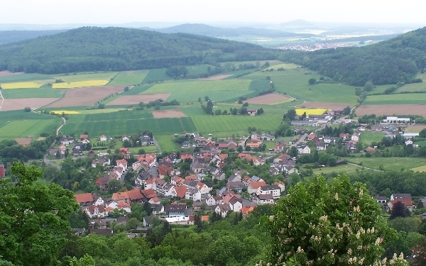
Niedenstein's main town lies in the southeast of the Habichtswald Nature Park right on the western slope of the Langenberge, a low mountain range reaching 557 m. The nearest city is Kassel, about 15 km to the northeast.
Neighbouring communities
In the north, Niedenstein abuts Schauenburg, in the east beyond the Langenberge on Baunatal and Edermünde and in the southeast by its constituent community of Metze on Gudensberg. In the south, the constituent community of Kirchberg, through which flows the river Ems, borders on Fritzlar, whose main town lies about 11 km away from Niedenstein. In the west, Niedenstein borders on Bad Emstal.
Constituent communities
The town has five centres. Besides the main town, also called Niedenstein, there are Ermetheis, Metze (about 1000 inhabitants), Kirchberg (about 900 inhabitants) and Wichdorf.
History
Niedenstein Castle had its first documentary mention in 1254.
Politics
Town council
Niedenstein's town council is made up of 23 members.
(as of municipal elections held on 26 March 2006)
Town partnership
Niedenstein maintains a partnership with one place:
 St. Germer de Fly, France
It lies about 80 km northwest of Paris in Picardy.
Culture and sightseeing
Museums
Niedenstein is home to the Heimatmuseum Kirchberg ("Kirchberg Homeland Museum")
Buildings
- Evangelical Village Church
- Altenburg; a settlement built up on a basalt crag, once a pre-Germanic castle village that was forsaken even before the Christian Era, making its earlier identification with the Chatti's capital Mattium unfounded. There are many archaeological finds on show from the Altenburg at the Hessian State Museum in Kassel.
Natural monuments
- Niedensteiner Kopf (475 m above sea level)
- Tanz- und Gerichtslinde ("Dance and Court Linden", on the way out of town to the west)
Personalities
- Jürgen Schweinebraden, Freiherr von Wichmann-Eichhorn, gallery owner and publisher
References
- ^ "Die Bevölkerung der hessischen Gemeinden" (in German). Hessisches Statistisches Landesamt. 31 December 2010. http://www.statistik-hessen.de/static/publikationen/A/AI2_AII_AIII_AV_10-1hj_pdf.zip.
- This article incorporates information from the German Wikipedia.
External links
Bad Zwesten | Borken | Edermünde | Felsberg | Frielendorf | Fritzlar | Gilserberg | Gudensberg | Guxhagen | Homberg | Jesberg | Knüllwald | Körle | Malsfeld | Melsungen | Morschen | Neuental | Neukirchen | Niedenstein | Oberaula | Ottrau | Schrecksbach | Schwalmstadt | Schwarzenborn | Spangenberg | Wabern | Willingshausen Categories:
- Towns in Hesse


Wikimedia Foundation. 2010.