- Oberaula
-
Oberaula 

 OberaulaLocation of Oberaula within Schwalm-Eder-Kreis district
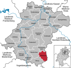

Coordinates 50°51′N 9°28′E / 50.85°N 9.46667°ECoordinates: 50°51′N 9°28′E / 50.85°N 9.46667°E Administration Country Germany State Hesse Admin. region Kassel District Schwalm-Eder-Kreis Local subdivisions 6 Ortsteile Mayor Karl Heinz Vestweber (SPD) Basic statistics Area 43.95 km2 (16.97 sq mi) Elevation 280-590 m Population 3,232 (31 December 2010)[1] - Density 74 /km2 (190 /sq mi) Other information Time zone CET/CEST (UTC+1/+2) Licence plate HR Postal code 36280 Area code 06628 Website www.oberaula.de Oberaula is a community in the Schwalm-Eder district in Hesse, Germany.
Contents
Geography
Location
Oberaula lies in the Knüllgebirge, a low mountain range, in the Aula river valley and its neighbouring valleys.
The nearest towns are Bad Hersfeld (about 20 km to the east), Schwalmstadt (about 25 km to the west), and Homberg (about 27 km to the north).
Constituent communities
The community consists of the six centres of Hausen, Friedigerode, Ibra, Oberaula (administrative seat), Olberode and Wahlshausen.
History
Oberaula had its first mention in 856 as Ovilaha (roughly "the place in a moist river floodplain" or "the place at the owl water"). The constituent community of Hausen was first mentioned in 1160. Quite early on, the Fulda Abbey had a castle with a moat in Hausen, upon whose remains the Barons of Dörnberg built their Renaissance stately home in 1674.
Amalgamations
As part of municipal reforms, the two communities of Oberaula and Hausen merged on 1 April 1972. On 1 January 1974 came the formation of the Greater Community of Oberaula with the amalgamation of the other above-named communities with Oberaula.
Politics
Municipal council
The council is made up of 23 members. As of the last municipal elections held on 26 March 2006, the seats are apportioned thus:
SPD : 11 seats CDU : 12 seats The community executive consists of 7 members. Four of these seats are held by the CDU and three by the SPD.
The mayor Karl Heinz Vestweber (SPD) was elected on 30 November 2003 with a 73.7% share of the vote.
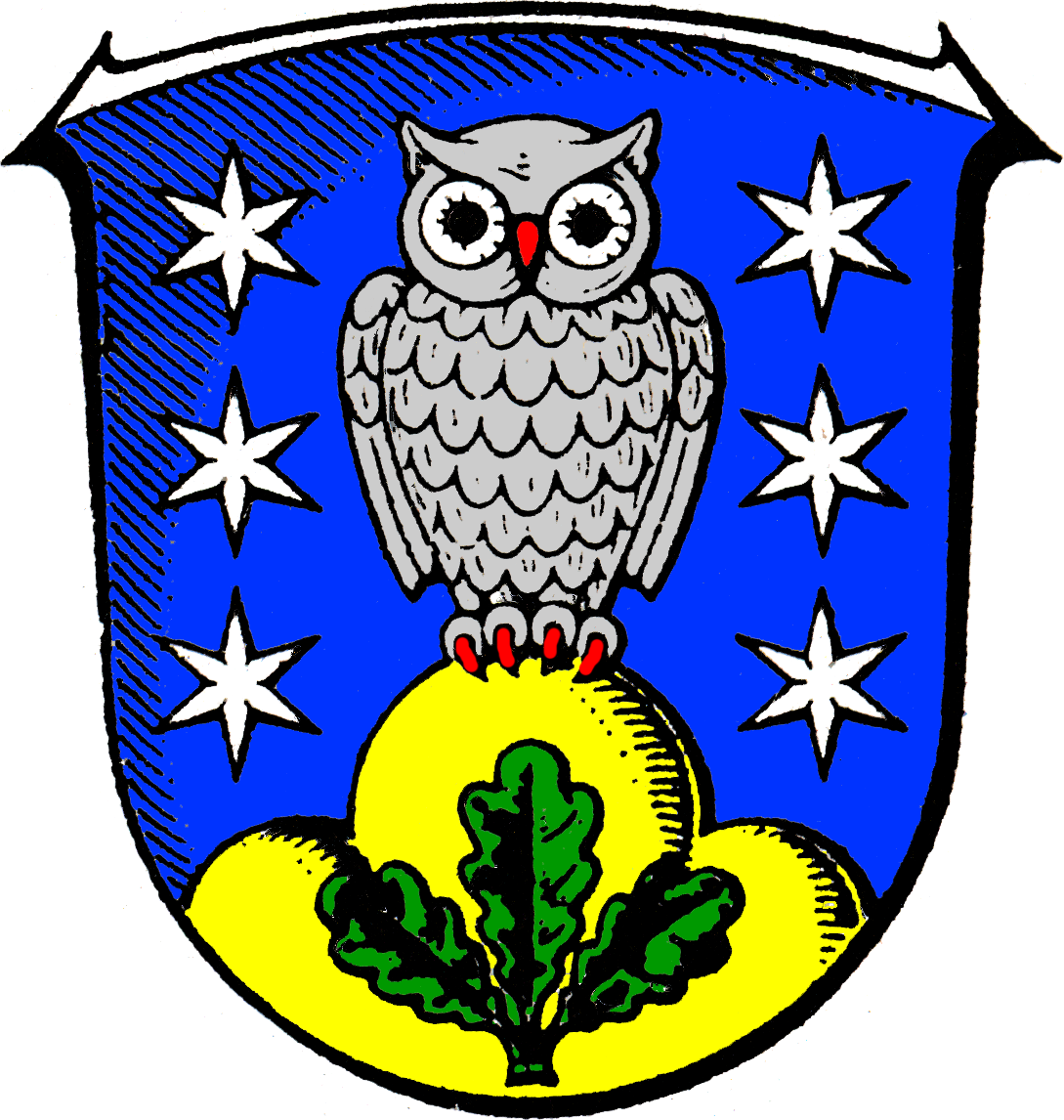
Coat of arms
Oberaula's civic coat of arms might heraldically be described thus: Azure an owl argent armed gules flanked by six mullets of six of the second and standing on a mount of three Or surmounted by a three-leafed oak sprig vert.
The blue background has its roots in a traditional story that mentions a blue flag. The owl stands for Oberaula and the six stars for the six constituent communities. The stars were chosen as the Counts of Ziegenhain, who held sway in the area for centuries, bore the star in their arms. The three-knolled hill – called a Dreiberg in German heraldry – stands for the Knüllgebirge in which the community lies, and the oak sprig refers to the community's membership in the former Kurhessen-Waldeck Tourist Association.
Municipal partnerships
Culture and sightseeing
Buildings
Economy and infrastructure
Transport
Oberaula lies on Federal Highway (Bundesstraße) B 454 (Kirchhain – Niederaula).
The community belongs to the North Hesse Transport Network.
Through the railway stations at Bad Hersfeld and Treysa, the community is connected to the railway network. The former Knüllwaldbahn railway between Bad Hersfeld and Treysa is out of service.
Personalities
Sons and daughters of the community
- Wilhelm Caspar Ferdinand Freiherr von Dörnberg (born 14 April 1768 in Schloss Hausen, died 19 March 1850 in Münster) was a German general and freedom fighter.
Sundry
Oberaula shares its name with nearby Niederaula (Ober = "upper"; Nieder = "lower") in the neighbouring Hersfeld-Rotenburg district.
References
- ^ "Die Bevölkerung der hessischen Gemeinden" (in German). Hessisches Statistisches Landesamt. 31 December 2010. http://www.statistik-hessen.de/static/publikationen/A/AI2_AII_AIII_AV_10-1hj_pdf.zip.
- This article incorporates information from the German Wikipedia.
External links
- Community's history
- Burschenschaft Oberaula
Bad Zwesten | Borken | Edermünde | Felsberg | Frielendorf | Fritzlar | Gilserberg | Gudensberg | Guxhagen | Homberg | Jesberg | Knüllwald | Körle | Malsfeld | Melsungen | Morschen | Neuental | Neukirchen | Niedenstein | Oberaula | Ottrau | Schrecksbach | Schwalmstadt | Schwarzenborn | Spangenberg | Wabern | Willingshausen Categories:
- Municipalities in Hesse


Wikimedia Foundation. 2010.