- Naval Air Facility El Centro
-
Naval Air Facility El Centro 
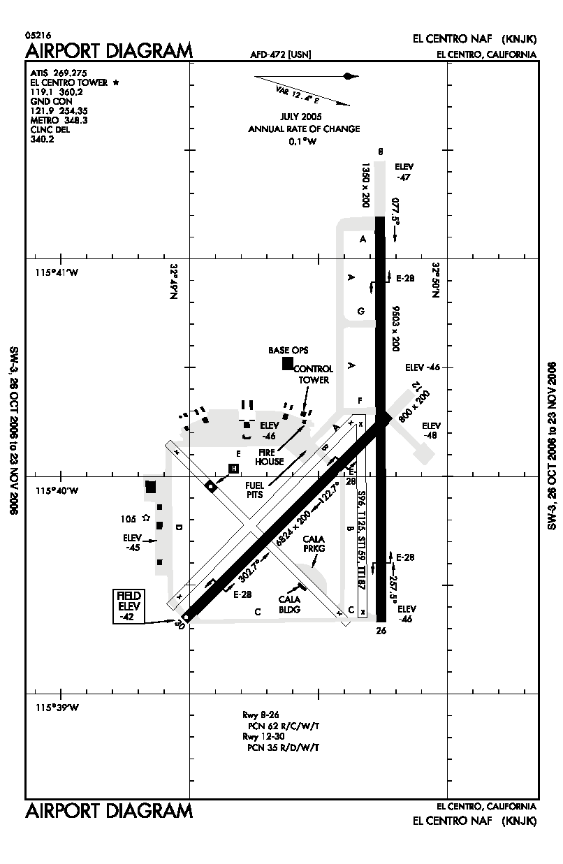
IATA: NJK – ICAO: KNJK - FAA: NJK Summary Airport type Naval Air Facility Operator United States Navy Location Imperial County, near El Centro, California Built May 1, 1946 In use Active Commander Captain James A. Hubbard Coordinates 32°49′45″N 115°40′18″W / 32.82917°N 115.67167°W Runways Direction Length Surface ft m 8/26 9,503 2,897 PEM 12/30 6,824 2,080 PEM 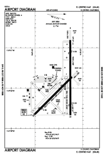 FAA Airport Diagram
Naval Air Facility El Centro or NAF El Centro (IATA: NJK, ICAO: KNJK, FAA LID: NJK) is a military airport located six miles (10 km) northwest of El Centro, in Imperial County, California, USA.
Contents
History
The facility was commissioned on May 1, 1946, as a Naval Air Station. Prior to that, the base was a Marine Corps Air Station. Through the years, Navy El Centro has had several names: Naval Air Facility, Naval Auxiliary Landing Field, Naval Air Station, and the National Parachute Test Range.
For the first 35 years, the mission of NAF El Centro was devoted to aeronautical escape system testing, evaluation, and design. In November 1947, the Parachute Experimental Division from Naval Air Station Lakehurst, New Jersey moved to El Centro. In 1951, the Joint Parachute Facility was established and consisted of the Naval Parachute Unit and the U.S. Air Force's 6511th Test Group (Parachute). The Air Force remained part of El Centro’s test organization for the next 27 years.
Current operations
The facility has two operating runways. The 9,500-foot (2,900 m) east/west runway handles 96 percent of the traffic. It is equipped with a Fresnel Lens Optical Landing System (FLOLS) at each approach end as well as lighted carrier flight deck landing areas at both ends so pilots can simulate carrier landings.
Apart from "touch and go" landings and take-offs, aircrews use the many ranges at NAF El Centro to develop their skills. A remote-controlled target area allows naval aviators and naval flight officers to practice ordnance delivery. The desert range is used for air-to-ground bombing, rocket firing, strafing, dummy drops and mobile land target training. The target complex uses the Weapons Impact Scoring System that microwaves target images to a range master control building for immediate verification of weapons delivery accuracy.
The addition of the Display and Debriefing Subsystem, known as DDS, expanded the role of NAF El Centro to include air combat training by utilizing remote television, acoustical and laser scoring systems. The DDS is linked with the Tactical Air Crew Training System (TACTS) to provide a computerized record of the tactics employed by individual aircrews employ and to evaluate the effectiveness of each maneuver.
Air Show
NAF El Centro is the winter home of the U.S. Navy Flight Demonstration Squadron, The Blue Angels. NAF El Centro historically kicks off the Blue Angels' season with their first air show, traditionally held in March.
Popular culture
Much of the movie "Jarhead" was filmed around El Centro and many of the extras from the movie were from NAF El Centro.
References
- Naval Air Facility El Centro (official site)
- Naval Air Facility El Centro GlobalSecurity.org. Retrieved 2006-10-26
- History of Naval Air Facility El Centro (California State Military Museum) Retrieved 2011-10-6
- FAA Airport Master Record for NJK (Form 5010 PDF)
External links
- Resources for this U.S. military airport:
- AirNav airport information for KNJK
- ASN accident history for NJK
- NOAA/NWS latest weather observations
- SkyVector aeronautical chart for KNJK
- FAA Airport Diagram (PDF), effective 20 October 2011
Operational military installations of CaliforniaArmy  FortAirfieldHeliportRange
Marines  Air StationCampRangeLogistics
Navy  DepotOutlying FieldPortStationRangeSchool
Air Force  Range
RangeNational Guard  School
Coast Guard  StationCategories:
- Airports in Imperial County, California
- United States Navy bases
- United States naval air stations
- Buildings and structures in Imperial County, California

Wikimedia Foundation. 2010.