- Evilard
-
Evilard Country Switzerland 
Canton Bern District Biel/Bienne 47°09′N 7°14′E / 47.15°N 7.233°ECoordinates: 47°09′N 7°14′E / 47.15°N 7.233°E Population 2,371 (Dec 2010)[1] - Density 641 /km2 (1,660 /sq mi) Area 3.70 km2 (1.43 sq mi) Elevation 697 m (2,287 ft) Postal code 2533 SFOS number 0372 Surrounded by Biel/Bienne, Lamboing, Orvin, Tüscherz-Alfermée Website www.evilard.ch
SFSO statistics
 Evilard
View map of Evilard Evilard is a municipality in the Biel/Bienne administrative district in the canton of Bern in Switzerland. The German name of the bilingual municipality is Leubringen.
Contents
Geography
Evilard lies 697 meters (2,287 ft) above sea level, and 1 kilometer (0.62 mi) north of the district capital city, Biel/Bienne, as the crow flies. The town spans a southeast-facing clearing of the front of the Jura mountains, about 300 m (980 ft) over the city of Biel. In clear weather, the view from Evilard of the Swiss plateau and the Alps from Mont Blanc to the region of Glärnisch and Alpstein is quite impressive.
The municipality reaches to the height of the anticline of Magglingerberg. It includes the town of Evilard, which is surrounded by Malewagwald (French: Malvaux, up to 765 m (2,510 ft) altitude). To the southwest, the municipality reaches in a narrow strip over the Magglingen to the peak of the Magglingerberg, up to the municipal high point of 1,070 m (3,510 ft).
Evilard has an area, as of 2009[update], of 3.68 km2 (1.42 sq mi). Of this area, 1.1 km2 (0.42 sq mi) or 29.9% is used for agricultural purposes, while 1.47 km2 (0.57 sq mi) or 39.9% is forested. Of the rest of the land, 1.07 km2 (0.41 sq mi) or 29.1% is settled (buildings or roads).[2]
Of the built up area, housing and buildings made up 19.6% and transportation infrastructure made up 4.6%. Power and water infrastructure as well as other special developed areas made up 1.1% of the area while parks, green belts and sports fields made up 3.8%. 38.6% of the total land area is heavily forested and 1.4% is covered with orchards or small clusters of trees. Of the agricultural land, 6.5% is used for growing crops and 23.1% is pastures.[2] [3]
In the municipality is also the town Magglingen (French: Macolin), which lies at 875 m (2,871 ft) on the southeast slope of Magglingerberg. The neighboring municipalities are Biel/Bienne, Orvin, Lamboing, and Tüscherz.
Population
Population growth Year Population 1850 365 1900 560 1910 633 1930 870 1950 1112 1960 1467 1970 1914 1980 2275 1990 2360 2000 2376 With a population (as of 31 December 2010) of 2,371[1], Evilard is one of the largest municipalities in the Bernese Jura. 10.7% of the population are foreign nationals. The population of Evilard underwent marked growth in the middle of the 20th century, whereas since 1980 only a small fluctuation has been registered. Over the last 10 years, the population has remained basically constant. Most of the population (as of 2000[update]) speaks German (60.0%), with French being second most common (34.1%), and Italian being third (1.5%). The migration of a number of settlers from the German-speaking portions of the Canton of Bern has increased the proportion of German speakers in Evilard, an area that was historically dominated by French speakers.
In the 2007 election, the most popular party was the FDP which received 30.6% of the vote. The next three most popular parties were the SPS (20.7%), the SVP (18.4%) and the Green Party (17%).
The age distribution of the population (as of 2000[update]) is children and teenagers (0–19 years old) make up 20.1% of the population, while adults (20–64 years old) make up 59.3% and the seniors (over 64 years old) make up 20.7%. The entire Swiss population is generally well educated. In Evilard about 85.5% of the population (between age 25-64) have completed either non-mandatory upper secondary education or additional higher education (either university or a Fachhochschule).
Evilard has an unemployment rate of 1.06%. As of 2005[update], there were 32 people employed in the primary economic sector and about 9 businesses involved in this sector. 29 people are employed in the secondary sector and there are 11 businesses in this sector. 555 people are employed in the tertiary sector, with 50 businesses in this sector.[3]
Economy
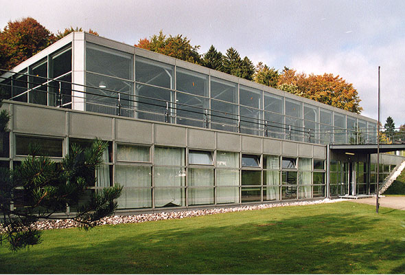
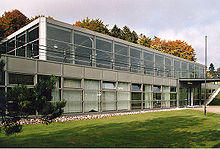 Jubilee Hall of the Eidgenössische Hochschule für Sport Magglingen
Evilard was dominated by agriculture until the beginning of the 20th century. Since about 1950, the town has built a large number of single-family homes for commuters working in Biel/Bienne. Magglingen has developed into a resort location starting in about 1875, thanks to its sunny high altitude. Today the town has many tourist facilities, and includes the Swiss Federal Office of Sport (FOSPO), the Swiss federal government’s centre for expertise in sports.
Transport
Transport within the municipality is well-developed. It is linked with Biel/Bienne and Orvin by road. In 1898 the Biel/Bienne–Leubringen/Evilard funicular between Biel/Bienne and Evilard was opened. Magglingen is also connected to Biel/Bienne by the Biel/Bienne–Magglingen/Macolin funicular.
History
The first appearance of Evilard in written documents was in 1300, under the name Lomeringen. The French name was Evillard or es Villard ("in the town"). A number of monasteries and the Bishopric of Basel were founded in the Middle Ages in the area. However, judicially and militarily the town was subordinate to the city of Biel. From 1798 to 1815, Evilard belonged to France and was part of the département of Mont-Terrible, which was joined with Haut-Rhin in 1800. At the Congress of Vienna in 1815, the town was returned to Switzerland and placed in the Canton of Bern. At first, Evilard was attached to the Oberamt Nidau; in 1832 it was placed in the Biel district. At times, there is debate over merging with the city of Biel; such a situation was however rejected by the residents in 1902. Evilard doesn't have its own church parish, but until 1821 belonged to the parish of Orvin, and since then to that of Biel.
External links
- Evilard in German, French and Italian in the online Historical Dictionary of Switzerland.
- (German) Eidgenössische Hochschule für Sport Magglingen
References
- ^ a b Swiss Federal Statistical Office - STAT-TAB, online database – Datenwürfel für Thema 01.2 - Bevölkerungsstand und -bewegung (German) accessed 29 September
- ^ a b Swiss Federal Statistical Office-Land Use Statistics 2009 data (German) accessed 25 March 2010
- ^ a b Swiss Federal Statistical Office accessed 29-May-2009
Aegerten | Bellmund | Biel/Bienne | Brügg | Ipsach | Lengnau | Evilard/Leubringen | Ligerz | Meinisberg | Mörigen | Nidau | Orpund | Pieterlen | Port | Safnern | Scheuren | Schwadernau | Sutz-Lattrigen | Twann-Tüscherz
Canton of Bern | Districts of Canton Bern | Municipalities of the canton of Bern
 Categories:
- Municipalities of Bern
- Municipalities of Switzerland


Wikimedia Foundation. 2010.