- Choke Canyon Reservoir
-
Choke Canyon Reservoir 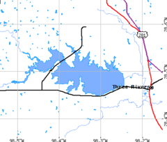
area map Location Live Oak / McMullen counties, Texas, USA Coordinates 28°30.00′N 98°21.00′W / 28.5°N 98.35°WCoordinates: 28°30.00′N 98°21.00′W / 28.5°N 98.35°W Lake type Water supply reservoir Primary inflows Frio River Primary outflows Frio River Basin countries United States Surface area 25,670 acres (10,390 ha) Max. depth 95.5 ft (29.1 m) Water volume 695,000 acre·ft (857,000,000 m3) Surface elevation 220.5 ft (67.2 m) Choke Canyon Reservoir is a reservoir in southern Texas, USA. The lake and the dam that creates it are managed by the City of Corpus Christi.
Contents
Geography
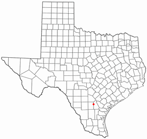
 Location in Texas
Choke Canyon Reservoir is 4 miles (6 km) west of the town of Three Rivers and about 65 miles (105 km) south of the city of San Antonio. It impounds water from the Frio River shortly before the river's confluence with the Nueces River. The reservoir covers 25,670 acres (103.9 km²) in Live Oak and McMullen counties, and has a capacity of more than 695,000 acre feet (857,000,000 m3) of water.
Uses
Choke Canyon Reservoir provides drinking water for the city of Corpus Christi. The reservoir also provides good fishing opportunities, especially for largemouth bass and catfish. Choke Canyon State Park, located in two places on the south shore of the lake, provides access to the lake and a number of other recreational activities.
Fish and plant life
Choke Canyon Reservoir has been stocked with species of fish intended to improve the utility of the reservoir for recreational fishing. Fish present in Choke Canyon Reservoir include alligator gar, white bass, white crappie, catfish, and largemouth bass, sunfish, and bluegill. Plant life in the lake includes American pondweed, coontail, water stargrass, rushes, cattail, and hydrilla.
External links
- Texas Parks & Wildlife Department pages for Choke Canyon Reservoir and Choke Canyon State Park
- Choke Canyon Reservoir at recreation.gov
Categories:- South Texas geography stubs
- Reservoirs in Texas
- Protected areas of Live Oak County, Texas
- Protected areas of McMullen County, Texas

Wikimedia Foundation. 2010.