- New York State Route 242
-
NYS Route 242
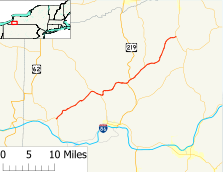
Map of Cattaraugus County with NY 242 highlighted in redRoute information Maintained by NYSDOT Length: 31.96 mi[2] (51.43 km) Existed: 1930[1] – present Major junctions West end:  NY 394 in Randolph
 US 219 in Ellicottville
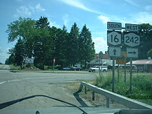
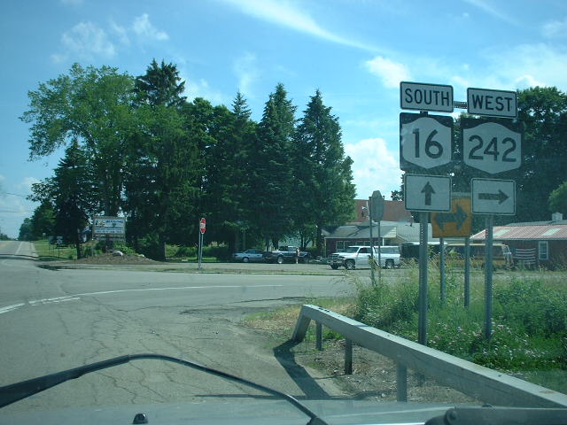
East end:  NY 16 in Machias
Location Counties: Cattaraugus Highway system Numbered highways in New York
Interstate • U.S. • N.Y. (former) • Reference • County←  NY 241
NY 243  →
→←  NY 17G
NY 17J  →
→New York State Route 242 (NY 242) is a state highway that runs across Cattaraugus County, New York, in the United States. Although signed as an east–west route, it takes a more northeast–southwest course across the county from NY 394 near the village of Randolph to NY 16 in Machias. The western end between Randolph and Little Valley was the western half of the short-lived New York State Route 17H. The eastern half of NY 17H was the southern end of NY 353 from Little Valley to Salamanca.
Contents
Route description
 Eastern terminus of NY 242 in Machias
Its western end is a junction with NY 394 at Stillson Pond east of Randolph. From there it crosses Napoli en route to the village of Little Valley, the county seat, where it merges briefly downtown with NY 353.
Continuing northeast through the towns of Little Valley and Mansfield, it takes a circuitous course through valleys and over a ridge to Ellicottville, where it is also called Washington Street and again overlaps through the village, this time with U.S. Route 219 (US 219), and intersects Elizabeth Street twice. By turning onto Elizabeth Street at the first intersection and returning to NY 242 at the second intersection, cars traveling in either direction can reduce their travel distance slightly, and avoid congestion at the intersection of Jefferson Street and NY 242; however, through trucks are prohibited from using Elizabeth Street. After Ellicottville, it follows the Great Valley Creek northeast to Ashford, where NY 240 leaves to the north. It continues from there up into the swampy headwaters of the creek, until finally reaching its eastern terminus at NY 16 in Machias.
History
What is now NY 242 west of Little Valley was originally part of NY 17A, an alternate route of NY 17 between Randolph and Salamanca that was assigned in the mid-1920s. Between Little Valley and Salamanca, NY 17A overlapped with NY 18 on modern NY 353.[3][4] In the 1930 renumbering of state highways in New York, NY 17A was renumbered to NY 17H while NY 242 was assigned to a new roadway under construction between Little Valley and Ellicottville.[1][5] The NY 242 designation also continued northeast of Ellicottville to Machias as it does today; however, it initially followed what is now NY 240 and County Route 16 between Ashford and Machias.[6] It was rerouted by the following year to follow its current alignment between Ashford and Machias.[7] The NY 17H designation ceased to exist ca. 1937. The former routing of NY 17H west of Little Valley became an extension of NY 242 while the remainder of the route remained part of NY 18.[8][9]
Major intersections
The entire route is in Cattaraugus County.
Location Mile[2] Destinations Notes Town of Randolph 0.00 NY 394Village of Little Valley 9.53  NY 353 north
Western terminus of NY 242 / NY 353 overlap 10.74 NY 353 southEastern terminus of NY 242 / NY 353 overlap Village of Ellicottville 17.80 US 219 southWestern terminus of US 219 / NY 242 overlap Town of Ellicottville 18.79 US 219 northEastern terminus of US 219 / NY 242 overlap 22.46  NY 240
Southern terminus of NY 240 Machias 31.96 NY 161.000 mi = 1.609 km; 1.000 km = 0.621 mi References
- ^ a b Automobile Legal Association (ALA) Automobile Green Book, 1930–31 and 1931–32 editions, (Scarborough Motor Guide Co., Boston, 1930 and 1931). The 1930–31 edition shows New York state routes prior to the 1930 renumbering
- ^ a b "2008 Traffic Volume Report for New York State" (PDF). New York State Department of Transportation. June 16, 2009. p. 195. https://www.nysdot.gov/divisions/engineering/technical-services/hds-respository/NYSDOT%20TVR%202008%20by%20Route.pdf. Retrieved February 1, 2010.
- ^ "New York's Main Highways Designated by Numbers". The New York Times: p. XX9. December 21, 1924.
- ^ Rand McNally and Company (1926). Rand McNally Auto Road Atlas (western New York) (Map). http://www.broermapsonline.org/members/NorthAmerica/UnitedStates/Midatlantic/NewYork/unitedstates1926ra_008.html. Retrieved December 3, 2009.
- ^ Dickinson, Leon A. (January 12, 1930). "New Signs for State Highways". The New York Times: p. 136.
- ^ Standard Oil Company of New York (1930). Road Map of New York (Map). Cartography by General Drafting.
- ^ Kendall Refining Company (1931). New York (Map). Cartography by H.M. Gousha Company.
- ^ Standard Oil Company (1936). New York (Map). Cartography by General Drafting.
- ^ Standard Oil Company (1937). New York (Map). Cartography by General Drafting.
External links
Categories:- State highways in New York
- Transportation in Cattaraugus County, New York


Wikimedia Foundation. 2010.