- Tobacco Root Mountains
Geobox | Range
name=Tobacco Root Mountains
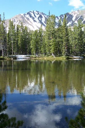
image_caption=Curly Lake in the Tobacco Root Mountains
country=United States
state=Montana
parent=Rocky Mountains
geology= | orogeny= | border=
length_imperial=| length_orientation=
width_imperial= | width_orientation=
highest=Hollowtop Peak
highest_elevation_imperial=10604
highest_lat_d=|highest_lat_m=|highest_lat_s=|highest_lat_NS=N
highest_long_d=|highest_long_m=|highest_long_s=|highest_long_EW=W
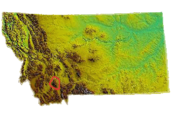
map_caption=The Tobacco Root Mountains lie in the northernRocky Mountains , between the Jefferson and Madison Rivers in southwest Montana. The highest peak is Hollowtop at convert|10604|ft|m|0. The range contains 43 peaks rising to elevations greater than 10,000 feet (3048 m).Much of the central part of the range is within the
Beaverhead-Deerlodge National Forest , although many, mostly small patented mining claims exist within the forest boundary. The range saw significant gold mining, especially during the 1880s to 1930s.The high peaks have been extensively glaciated, and most of the larger stream valleys held valley glaciers during the
ice age .Discovery and Nomenclature
When
Lewis and Clark came through southwest Montana in 1805, they named many rivers — but if they referred to the mountain ranges by name, the names are not recorded. The 1865 DeLacey Map of Montana Territory does not name the Tobacco Roots. The first written reference to the mountains between the Madison and Jefferson Rivers is F.V. Hayden’s 6th Annual Report of the Geological Surveys of the Territories for 1873, in which the name South Bowlder Range is mentioned, a reference to the largest river in the north part of the mountains. Although this usage (usually spelled “South Boulder Range”) is followed in many Geographies and Atlases of the 1890s and early 1900s, the USGS Three Forks Folio [Peale, A.C., 1896, Three Forks Folio, U.S. Geological Survey] labels the mountains “Jefferson Range.”The earliest known use in print of the name Tobacco Root Mountains is Winchell’s (1914) report on mining districts of the Dillon Quad. [Winchell, A.N., 1914, "Mining Districts of the Dillon Quadrangle": USGS Bull. 574] The name was also used by Billingsley in a 1918 paper on the
Boulder Batholith , published by the American Institute of Mining Engineers. “Tobacco Root” appears in most subsequent publications, including Montana Bureau of Mines and Geology reports (at least since 1933), National Forest Maps (since 1938), and the Official Montana Highway Maps.However, a map in Fenneman’s "Physiography of Western United States" (1931) shows a long Jefferson Range to include what is now called the Tobacco Roots plus the
Gravelly Range . Oil Company highway maps from the late 1960s and early 1970s show “Tobacco Root Mountains” in the north, and “Jefferson Range” in the south (northwest of Ennis and north of Virginia City). Preliminary topographic maps of the area (Bureau of Reclamation, Missouri Basin Project) from 1947-48 show Jefferson Range, but on the 1950 15-minute sheet (Harrison Quad) the identical topography is labeled “Tobacco Root Mountains” in the same place as “Jefferson Range” on the maps that were just two years older.The 1947 Bozeman 1:250,000 shaded relief map has Jefferson Range, but the 1958 (Bozeman 1:250,000) and 1962 (Dillon) regular editions use Tobacco Root Mountains.
Origin of Name
The basis for the name Tobacco Root is unclear. John Willard ["Adventure Trails in Montana", by John Willard, sponsored by Montana Historical Society, 1971] says “Indians and early trappers found a root in these mountains that, when dried and mixed with larb, made a suitable substitute for real tobacco. The root was a species of
mullein .”The term "tobacco root" is also an old name for species of
arnica ; native and European-introduced arnica are wildflowers in Western Montana, including the Tobacco Root Mountains.Tansley, Shaffer and Hart (1933) [Tansley, W., Schafer, P.A., and Hart, L.H., 1933, "A geologic reconnaissance of the Tobacco Root Mountains, Madison County, Montana": Montana Bureau of Mines and Geology Memoir 9] attribute the practice of drying a species of mullein and mixing it with
kinnikinic (bearberry ) to replace tobacco to John Edwards, a prospector from Flint Creek, in the 1860s. He also gave the name to the hills in which the root was found. Kinnikinic, as the name of a mixture and not the bearberry plant, was a leaf-bark mixture, includingsumac anddogwood leaves, smoked by Indians and pioneers in the Ohio Valley in the 18th Century. It was probably more or less the same as the “larb” mentioned above.Other sources have reported the root to be a variety of the
bitterroot , Montana’s protected state flower.Shoshone Indians reportedly cooked the root and ate it, and it supposedly smelled like tobacco.Geology
The center of the range is occupied by the Tobacco Root
Batholith , thought to be a satellitepluton of theBoulder Batholith . [Reid, R.R., 1957, "Bedrock geology of the north end of the Tobacco Root Mountains, Madison County, Montana": Montana Bureau of Mines and Geology Memoir 36] ThisLate Cretaceous granitic body intrudesArchean gneisses and schists ["Precambrian Geology of the Tobacco Root Mountains, Montana", John B. Brady, H. Robert Burger, John T. Cheney, and Tekla A. Harms, editors, Geological Society of America Special Paper 377, 2004] Significant gold deposits appear to be related to the intrusion of the Tobacco Root Batholith and northwest-trending faults in the Pony area and elsewhere. The northern flank of the Tobacco Roots consists of thrusted and folded sedimentary and volcaniclastic rocks ranging fromProterozoic Belt Supergroup strata toCretaceous Elkhorn Mountains Volcanics. Thick sections ofPaleozoic andMesozoic strata, including theFlathead sandstone andMadison Limestone , are present. ["Tectonic controls for thrust belt and Rocky Mountain foreland structures in the northern Tobacco Root Mountains - Jefferson Canyon area", southwestern Montana, by C.J. Schmidt and T. E. Hendrix, Montana Geological Society Guidebook, Southwest Montana, 1981, p. 167-180.]Land Characteristics and Habitats
The land is used mostly in
livestock grazing andlogging . Land stewardship in the North Tobacco Root Mountains and Foothills area is as follows:
*U.S. Federal Agencies: 32,309 acres, or 14.4% of total area, which include:
*BLM: 17,544 acres, or 7.8% of total area
*USFS: 14,765 acres, or 6.6% of total area
*State Agencies: 20,695 acres, or 9.2% of total area
*Private: 171,985 acres, or 76.4% of total area [http://fwp.mt.gov/content/getItem.aspx?id=26488]There are 244 terrestrial
vertebrate species that are found within theNorth Tobacco Root Mountains and Foothills includingwhitetail andmule deer ,elk , and black bears. The area is also habitat to a handful of "Tier I" species (Montana Fish Wildlife and Park's classification of nativie species with greatest need of conservation [http://fwp.mt.gov/content/getItem.aspx?id=26526] , including theWestern Toad ,Flaummulated Owl ,Bald Eagle , Townsend'sBig-eared Bat ,Grizzly Bear , andCanada Lynx , who are all under threat of Habitat loss, degradation, and fragmentation, especially as a result of population growth/development [http://fwp.mt.gov/content/getItem.aspx?id=26488] .Notes
External links
* [http://trgs.org/list.htm Tobacco Root Geological Society]
* [http://www.fs.fed.us/r1/b-d/ Beaverhead-Deerlodge National Forest]
* [http://www.lewis-clark.org/content/content-article.asp?ArticleID=2630 Lewis and Clark Expedition's journal involving the Tobacco Roots]
* [http://www.ponymontana.com/ Events and information in and around Pony, MT]
Wikimedia Foundation. 2010.