- Meuro
-
Meuro Stadtteil of Bad Schmiedeberg 
 Meuro
MeuroCoordinates 51°44′N 12°42′E / 51.73333°N 12.7°ECoordinates: 51°44′N 12°42′E / 51.73333°N 12.7°E Administration Country Germany State Saxony-Anhalt District Wittenberg Town Bad Schmiedeberg Stadtteil subdivisions 4 Basic statistics Area 26.59 km2 (10.27 sq mi) Elevation 115 m (377 ft) Population 613 (31 December 2006) - Density 23 /km2 (60 /sq mi) Other information Time zone CET/CEST (UTC+1/+2) Licence plate WB Postal code 06905 Area code 034925 Website www.bad-schmiedeberg.de Meuro is a village and a former municipality in Wittenberg district in Saxony-Anhalt, Germany. Since 1 July 2009, it is part of the town Bad Schmiedeberg.
Contents
Geography and transport
Meuro lies about 20 km southeast of Lutherstadt Wittenberg and about 5 km northwest of Bad Schmiedeberg on the northern edge of the Dübener Heide (heath), putting the community's more southerly areas in the Dübener Heide Nature Park. West of the community runs the Federal Highway (Bundesstraße) B 2, which joins Berlin and Wittenberg, and to the north runs the B 187. The community is also crossed by a stream called the Flieth.
Subdivisions
Meuro consists of Ogkeln, Sackwitz, and Scholis.
Sightseeing
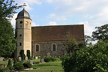
- Meuroer Fieldstone church
- Dübener Heide
External links
Categories:- Villages in Saxony-Anhalt
- Saxony-Anhalt geography stubs


Wikimedia Foundation. 2010.