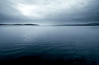
- Lake Mandrensko
-
Lake Mandrensko 
The water surface and an island Group Burgas Lakes Coordinates 42°25′24″N 27°23′29″E / 42.42333°N 27.39139°ECoordinates: 42°25′24″N 27°23′29″E / 42.42333°N 27.39139°E Lake type natural lake, reservoir Primary inflows Izvorska, Fakiyska, Sredetska and Rusokastrenska Basin countries Bulgaria Max. length 8 km Max. width 1.3 km Surface area 38.84 km² Lake Mandrensko or Lake Mandra (Bulgarian: Мандренско езеро, Mandrensko ezero) is the southernmost of the Burgas Lakes, located in the immediate proximity of the Black Sea and close to Burgas. Being 8 km long and 1.3 km wide at maximum, as well as having an area of 38.84 km², it was a brackish natural lake until 1963, when it was turned into a reservoir with the construction of a dam to secure fresh water for the large Neftochim Burgas oil refinery. The rivers Izvorska, Fakiyska, Sredetska and Rusokastrenska flow into the lake.
Parts of Lake Mandrensko are designated protected areas inhabited by a number of locally and globally endangered species of fish and birds.
Categories:- Burgas Lakes
- Bulgaria geography stubs
Wikimedia Foundation. 2010.


