- Ambler Airport
-
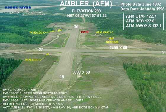
Ambler Airport 
IATA: ABL – ICAO: PAFM – FAA LID: AFM Summary Airport type Public Owner Alaska DOT&PF - Northern Region Serves Ambler, Alaska Elevation AMSL 334 ft / 102 m Coordinates 67°06′23.9″N 157°51′25.6″W / 67.106639°N 157.857111°W Runways Direction Length Surface ft m 9/27 2,400 732 Gravel 18/36 3,000 914 Gravel Statistics (2008) Enplanements 2,357 Source: Federal Aviation Administration[1][2] Ambler Airport (IATA: ABL, ICAO: PAFM, FAA LID: AFM) is a state-owned public-use airport located one nautical mile (1.85 km) north of the central business district of Ambler,[1] a city in the Northwest Arctic Borough of the U.S. state of Alaska.
As per Federal Aviation Administration records, the airport had 2,357 passenger boardings (enplanements) in calendar year 2008, an increase of 0.13% from the 2,354 enplanements in 2007.[2] This airport is included in the FAA's National Plan of Integrated Airport Systems for 2009–2013, which categorizes it as a general aviation facility.[3]
Although most U.S. airports use the same three-letter location identifier for the FAA and IATA, this airport is assigned AFM by the FAA[1] and ABL by the IATA.[4] The airport's ICAO identifier is PAFM.[5]
Contents
Facilities
Ambler Airport covers an area of 272 acres (110 ha) at an elevation of 334 feet (102 m) above mean sea level. It has two runways with gravel surfaces: 9/27 measures 2,400 by 60 feet (732 x 18 m) and 18/36 is 3,000 by 60 feet (914 x 18 m).[1]
Airline and destinations
Airlines Destinations Bering Air Shungnak[6] Era Alaska Kotzebue[7] References
- ^ a b c d FAA Airport Master Record for AFM (Form 5010 PDF), effective 2009-07-02.
- ^ a b CY 2008 Passenger Boarding and All-Cargo Data. Federal Aviation Administration. Updated 18 December 2009.
- ^ National Plan of Integrated Airport Systems for 2009–2013: Appendix A: Part 1 (PDF, 1.33 MB). Federal Aviation Administration. Updated 15 October 2008.
- ^ Great Circle Mapper: ABL / PAFM - Ambler, Alaska
- ^ "Alaskan ICAO Identifiers". Federal Aviation Administration. http://www.faa.gov/air_traffic/publications/atpubs/LID/L_G2.htm. Retrieved 2009-08-07.
- ^ Bering Air: Kotzebue Flight Schedule (PDF). Retrieved 29 Aug 2007.
- ^ Era Alaska Timetable (PDF). Retrieved April 17, 2011.
External links
- FAA Alaska airport diagram (GIF)
- FAA Terminal Procedures for AFM, effective 20 October 2011
- Resources for this airport:
- AirNav airport information for PAFM
- ASN accident history for ABL
- FlightAware airport information and live flight tracker for PAFM
- NOAA/NWS latest weather observations for PAFM
- SkyVector aeronautical chart for AFM
Categories:- Airports in Northwest Arctic Borough, Alaska
Wikimedia Foundation. 2010.