- Rawalpindi Tehsil
Infobox Tehsil Pakistan
tehsil_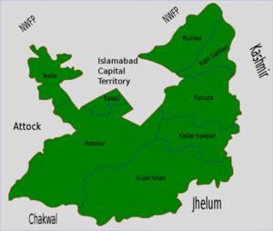
caption = Rawalpindi is located in the north of Rawalpindi District.
official_name= Rawalpindi
راولپنڈی
province= Punjab
district= Rawalpindi
area_total_km2=
census_year= 1998
estimate_year=
census_pop=
estimate_pop=
population_density_km2=
towns=
uc=
nazim=
naib nazim =
footnotes=
map_size =
map_text =Location withinPakistan Rawalpindi is a
tehsil - an administrative subdivision - ofRawalpindi District in the western part of the Punjab province,Pakistan , it contains the district capital - the city ofRawalpindi .History
Ancient History
Archaeological remains found on the site of the city of Rawalpindi date the establishment of settlements there to ancient times. There are ruins of a Buddhist settlement contemporary to the more celebrated ruins at nearby
Taxila . It is thought that aHun raid destroyed the first city.Ghakkar Rule
The Muslim ruler
Mahmud of Ghazni gifted the ruined city to aGhakkar chief,Kai Gohar . Because it was vulnerable to invaders, the town remained deserted until another Ghakkar chief,Jahanda Khan , restored it and named it Rawalpindi (after the village Rawal).ikh Rule
Rawalpindi remained under the rule of Ghakkars until
Muqrab Khan , the last Ghakkar ruler, was defeated bySikhs in 1765. Under Sikh rule, traders were invited to settle in Rawalpindi. A thriving trade was established, but during the nineteenth century the Sikhs lost the city to the British, who established acantonment south of the old city.British Rule
In 1879, the
Punjab Northern Railway was extended to Rawalpindi. The train service was formally inaugurated onJanuary 1 ,1886 . It housed the Headquarters of Northern Command of the British Army until 1947, and thereafter the Headquarters of the Pakistan Army.The tehsil was described in the
Imperial Gazetteer of India as follows:"North-western tahsil of Rawalpindi District, Punjab, lying between 33°19' and 33°50' N. and 72°34' and 73°23' E., with an area of 764 square miles. The population in 1901 was 261,101, compared with 243,141 in 1891. The tahsil contains the town and cantonment of RAWALPINDI (population, 87,688), the head-quarters ; and 448 villages. The land revenue and cessesin 1903-4 amounted to 2.6 lakhs. MANIKIALA and SHAHDHERI are places of great archaeological interest. The Sohan river, which crosses the tahsil from east to west, divides it into two distinct portions.To the north lie the rich plains round Rawalpindi town, sloping up to the outlying spurs of the Himalayas, which form the northern boundary of the tahsil. To the south the country is cut up by torrent beds and ravines into little plateaux, which vary in soil and character, but resemble each other in difficulty of access". [ [http://dsal.uchicago.edu/reference/gazetteer/pager.html?objectid=DS405.1.I34_V21_277.gifRawalpindi Town - Imperial Gazetteer of India, v. 21, p. 271] ]
Over the years, Rawalpindi has retained its traditional culture, though it has been extensively modernized since the creation of Pakistan in 1947. It is twinned with
Islamabad , Pakistan's new capital.The Old City and Rawalpindi Bazaars
The
bazaar s of the old city are famous for quaint old shops in Saddar bazaar, Moti bazaar, Raja bazaar and Kashmiri bazaar. Sarafa bazaar is famous for beaten gold and silver jewellery, brass and copper-ware.Rawalpindi has long been a major market for exports from
Kashmir and theNorth-West Frontier Province . The bazaars specialize in handicrafts such as inlaid sheesham and walnut furniture, Kashmiri silver, shawls and jackets, embroidered and woollenkurta s and household linen, potohar shoes andchappal s, cane baskets and furniture, walking sticks, and hand-woven Kashmiri and Bokhara carpets.Parks and Gardens
*
Ayub National Park is located beyond the old Presidency on Grand Trunk (G.T.) Road. It covers an area of about 2,300 acres and has a play area, lake with boating facility, an aquarium, a garden-restaurant and an open air theatre.
*Liaquat National Bagh , sometimes known as Liaquat Bagh and formerly Municipal Park, is of historical interest. The first prime minister of Pakistan, KhanLiaquat Ali Khan , was assassinated here in 1950.
*Situated near Ayub National Park,Rawalpindi Golf Course was completed in 1926 by Rawalpindi Golf Club, one of the oldest golf clubs of Pakistan. The facility was initially developed as a nine-hole course. After several phases of development, it is now a 27-hole course. From the clubhouse, there is a panoramic view of Faisal Mosque, the twin cities ofIslamabad and Rawalpindi, and the course itself. Major golf tournaments are regularly held here.
*Rawalpindi Public Park (well known as Nawaz Sharif Part)is located on Murree Road nearShamsabad . The Park was opened in 1991. It has a play area for children, lawns, fountains and flower beds. Acricket stadium was built in 1992 opposite the Public Park. The 1996 World Cup cricket matches were held on this cricket ground.ports venues and stadiums
*Rawalpindi Cricket Stadium
*KRL Cricket Stadium
*Army Hockey Stadium
*Army Football Stadium
*Municipal Football Stadium, Satellite Town
*Jinnah Park, near Kachari Chowk, Civil Lines
*Romi Park, Peshawar RoadReferences
External links
* [http://www.pindiplus.com Pindiplus Rawalpindi Videos, Pictures and Travel Guide]
* [http://www.rawalpindi.gov.pk Official Government website of Rawalpindi]

Wikimedia Foundation. 2010.