- Pennsylvania Route 973
-
PA Route 973
Route information Maintained by PennDOT Length: 26 mi[1] (42 km) Existed: 1928 – present Major junctions West end:  PA 44 in Watson Township
East end:  PA 87 in Loyalsockville
Location Counties: Lycoming Highway system Roads in Pennsylvania
Interstate • US • State • Legislative←  PA 972
PA 974  →
→Pennsylvania Route 973 (PA 973) is a highway which runs for 26 miles (42 kilometers) generally east–west in Lycoming County in north central Pennsylvania in the United States. Its western terminus is on the east bank of Pine Creek at Pennsylvania Route 44 in the unincorporated village of Tomb (or Tombs Run) in Watson Township, and its eastern terminus is at the hamlet of Loyalsockville in Eldred Township at Pennsylvania Route 87.
Contents
Route description
Starting at its western end in Tomb, PA 973 runs east along Tombs Run, then northeast along the North Fork of Tombs Run. It then heads east into Mifflin Township, following Mud Run and the First Fork of Larrys Creek before crossing Larrys Creek and Pennsylvania Route 287, and turning north into the borough of Salladasburg. It follows Larrys Creek northeast into Anthony Township, where it leaves Larrys Creek and follows Stoney Gap Run into Lycoming Township.
There Route 973 follows Hoaglands Run east through the village of Quiggleville and hamlet of Perryville, passing under U.S. Route 15 before crossing Lycoming Creek into Hepburn Township. Following Lycoming Creek southeast, Route 973 passes through the villages of Cogan Station and Hepburnville, then turns northeast to follow Mill Creek to the hamlet of Balls Mills, and on into Eldred Township. There it passes through the village of Warrensville, then the Loyalsock State Game Farm, and crosses Loyalsock Creek just before it meets PA 87 at Loyalsockville and its eastern end.
Flood damage
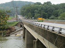 The destroyed PA 973 bridge over Loyalsock Creek, seen from PA 87.
On September 8, 2011 the bridge at the eastern end of the highway over Loyalsock Creek (known as the Slabtown Bridge) was destroyed by flooding. Heavy rain from the remnants of Tropical Storm Lee raised the creek "higher than anything we've seen in recorded history", according to a Lycoming County official. The western portion of the bridge collapsed.[2]
Major intersections
The entire route is in Lycoming County.
Location Mile Destinations Notes Watson Township 0 PA 44Western terminus Salladasburg  PA 287 south
West end of PA 287 concurrency PA 287 northEast end of PA 287 concurrency Cogan Station  US 15
US 15Interchange Loyalsockville 26 PA 87Eastern terminus 1.000 mi = 1.609 km; 1.000 km = 0.621 mi Footnotes
- ^ Pennsylvania Highways - Pennsylvania Route 973
- ^ Thompson, David (September 9, 2011). "‘Worse than Agnes’: Record flooding wreaks destruction". Williamsport Sun-Gazette: p. 1. http://www.sungazette.com/page/content.detail/id/568232/-Worse-than-Agnes-.html?nav=5011. Retrieved September 9, 2011.
External links
Categories:- State highways in Pennsylvania
- Transportation in Lycoming County, Pennsylvania


Wikimedia Foundation. 2010.