- Nampho
-
Namp'o Special City 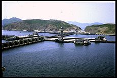
Korean name Chosŏn'gŭl 남포특별시 Hancha 南浦特別市 McCune–Reischauer Namp'o T'ŭkpyŏlsi Revised Romanization Nampo Teukbyeolsi Short name Chosŏn'gŭl 남포 Hancha 南浦 McCune–Reischauer Namp'o Revised Romanization Nampo Statistics Population 455,000 Government Special City in South P'yŏngan; former Directly Governed City* Region Kwansŏ Dialect P'yŏngan Notes - Administered as a Directly Governed City from 1980-2004.
Namp'o (North Korean official spelling: Nampho; Korean pronunciation: [nampɸo]) is a city and seaport in South P'yŏngan Province, North Korea. It was a provincial-level Directly Governed City (Chikhalsi) from 1980 to 2004, when it was designated a "Special City" (T'ŭkgŭpsi) and made a part of South P'yŏngan. Namp'o was designated a T'ŭkpyŏlsi (teukbyeolsi; 특별시; 特別市) "Special City" in 2010.
Namp'o is situated some 50 kilometres south west of P'yŏngyang, at the mouth of the Taedong River. It was originally a small fishing village, but opened as a port of foreign trade in 1897, and began to develop into a modern port after liberation in 1945. With the rapid increase in state investment, the city's industrial capacity grew.
Some of the industrial facilities are the Namp'o Smelter Complex, the Namp'o Glass Corporation, the Namp'o Shipbuilding Complex, the Namp'o Fishery Complex and other central and local factories. Namp'o is a center for the DPRK shipbuilding industry. North of the city are facilities for freight transportation, aquatic products, and fishery, and a sea salt factory. The apples grown in Namp'o's Ryonggang district (룡강군) are a famous local product.[1]
Contents
Geography
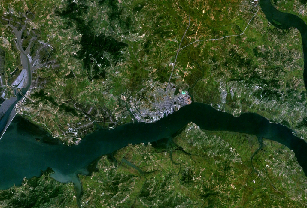
 View of the city/port from space.
Nampo lies on the northern shore of the Taedong River, 15 km east of the river's mouth. Although it has a continental climate and abundant flat land, agriculture in the area of Namp'o has been limited by low rainfall and a lack of fresh water.
Administrative divisions
Namp'o is divided into three guyŏk and several kun, which are in turn divided into dong and ri.
- Waudo-guyŏk (와우도구역/臥牛島區域)
- Hanggu-guyŏk (항구구역/港口區域)
- Ch'ŏllima-kun (천리마군; 千里馬郡)
- Kangsŏ-kun (강서군; 江西郡)
- Ryonggang-kun (룡강군/龍岡郡)
- Taean-kun (대안군; 大安郡)
Foreign aid
Nampho Harbour is often used as the primary port of call for the reception of foreign food aid assistance into North Korea. In 2008, the harbour received several batches of grain delivery, the first batch delivered in June was sent by the United States and weighed 38,000 tons. South Korean-based relief organisation Join Together Society donated one batch of flour in October of the same year weighing approximately 500 tons.[2]
Transportation
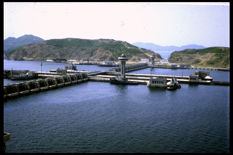
An airport, railway and a large freeway connect Namp'o to Pyongyang and other locations. Nampo Station is on the Pyongnam Line. The West Sea Barrage of the Namp'o port, built by erecting an 8-km long sea wall, has three lock chambers which allow the passage of ships up to 50,000 tons, and 36 sluices. The port of Namp'o has modern harbour facilities that can accommodate ships of 20,000 tons but is frozen during the winter. Namp'o serves as Pyongyang's port on the Yellow Sea.
Culture
Institutes of higher learning in Namp'o include Nampho University, Sohae University, Samgwang College, Sunhwa College, Nampho University of Medicine, Nampho University of Agriculture, Nampo College of Shipping Industry, Nampho Building Materials College, and Nampo University of Fisheries.
Tourist attractions include Waudo Pleasure Ground, with a sea bathing beach, a convalescent hospital and recreation facilities. Nearby scenic spots include the West Sea Barrage, three tombs in Kangso, the tomb in Tokhung-dong, Susan Spa, Chongsan Spa, Kangso Mineral Springs and Lake Thaesang.
Sister cities
Gallery
-

Nampo Lighthouse during Korea under Japanese rule's period.
Notes
- ^ "남포직할시" (in Korean). 한국민족대백과사전. http://100.empas.com/dicsearch/pentry.html?s=K&i=289275&v=47. Retrieved 2006-11-11. Kim, Nam-yong (金南龍). "남포직할시" (in Korean). Korean Britannica. http://preview.britannica.co.kr/spotlights/nkorea/geography/b03n3450b.html. Retrieved 2006-11-11.
- ^ KINU White paper on human rights in North Korea 2009 (Chapter G. Human Rights Violations Inside Political Concentration Camps (Kwanliso), page 125)
The U.S. technical research vessel USS Pueblo, that was captured by North Korea in 1968, was moored at the seaport. The vessel was moved to Nampho in 1999 from the east coast.
See also
External links
- Korea Tourist Map (English, Korean, Japanese, Chinese)
- North Korea Uncovered, (North Korea Google Earth) This map labels most of Nampo's infrastructure locations including hotels, nearby UNESCO sites, railroads, West Sea Barge, electricity grid, and shipping facilities.
- [1] (Korean) Has maps of most of North Korea, including districts, dong, and villages.
Metropolitan cities of North Korea Directly governed city Provincial capitals Cities (not included above) South P'yŏngan Capital 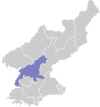
Cities Districts Ch'ŏngnam · Tŭkchang · UngokCounties Categories:- Cities in South Pyongan


Wikimedia Foundation. 2010.