- Iława
-
For the village of the same name, see Iława, Opole Voivodeship.
Iława Town view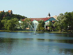
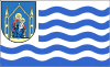
Flag
Coat of arms

 Iława
IławaCoordinates: 53°35′47″N 19°33′56″E / 53.59639°N 19.56556°E Country  Poland
Voivodeship Warmian-Masurian County Iława County Gmina Iława (urban gmina) Established 1305 Town rights 1305 Government – Mayor Włodzimierz Ptasznik Area – Total 21.88 km2 (8.4 sq mi) Highest elevation 150 m (492 ft) Lowest elevation 100 m (328 ft) Population (2006) – Total 32,326 – Density 1,477.4/km2 (3,826.5/sq mi) Time zone CET (UTC+1) – Summer (DST) CEST (UTC+2) Postal code 14-200 to 14-210 Area code(s) +48 89 Car plates NIL Website http://www.ilawa.pl Iława [iˈwava] (
 listen) (German: Deutsch Eylau (
 listen)) is a town in northeastern Poland with 33,912 inhabitants (2006). It is situated in the Warmian-Masurian Voivodeship (since 1999); previously it was in Olsztyn Voivodeship (1975–1998). It is the capital of Iława County.
Contents
History
The town was founded in Prussia in 1305 and is documented in a manuscript by Luther von Braunschweig in 1317. It was built on the Eylenz (Iławka) River between Lakes Geserich (Jeziorak) and Eylenz (Iławskie). This location makes it a popular vacation area. The town was under the jurisdiction of the komtur of Christburg (Dzierzgoń) and since 1340 under Osterode (Ostróda). In 1457 it was sold to King Casimir IV Jagiellon of Poland during the Thirteen Years' War between the cities of Prussia and the Teutonic Order. With the aid of Ulrich von Kinsberg the city was able to regain its independence from Poland.[citation needed]
As Deutsch Eylau, the town became part of the Duchy of Prussia in 1525 and the Kingdom of Prussia in 1701. Administered within the new province of West Prussia in 1773, it became part of the German Empire in 1871.
In 1862 the Oberland Canal (Elbląg Canal) was built between Elbing (Elbląg) and Eylau by engineer Georg Steenke, which enabled the inland town to transport bulk of lumber, farm products, and other goods north to Elbing and the Baltic Sea. This was superseded ten years later by rail transport, when the Thorn (Toruń)-Insterburg (Chernyakhovsk) railway line was constructed.
Following the Treaty of Versailles, this part of Prussia remained in Germany, as in the East Prussian plebiscite on being a part of Poland or Germany an overwhelming majority of votes was cast in favor of the latter option. It became part of Regierungsbezirk West Prussia in the Province of East Prussia.
As a result of the Potsdam Conference following World War II, Eylau was placed under Polish administration in 1945 and since then remains as part of Poland. Its former German population was expelled and replaced with Poles, many themselves expellees from Polish areas annexed by the Soviet Union.
Notable residents
- Richard Altmann (1852–1900), pathologist
- Friedrich Karst (1893–1975), general
- Helmuth Stieff (1901–1944), general and resistance fighter
- Joachim Meichssner (1906–1944), officer and resistance fighter
Gallery
-
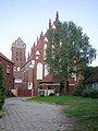
Gothic church in Iława
-
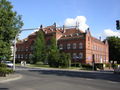
High school in Iława
-
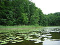
Jeziorak lake
-
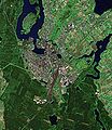
View from space
-
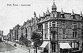
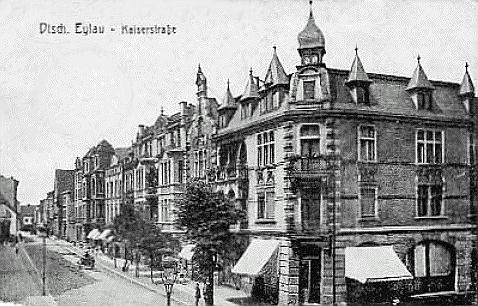
"Kaiserstraße", ca. 1910
International relations
Twin towns — Sister cities
Iława is twinned with: Iława is twinned with:
External links
Coordinates: 53°36′N 19°34′E / 53.6°N 19.567°E
Urban gminas Iława (seat) • Lubawa
Urban-rural gminas Rural gminas Gmina Iława Seat (not part of the gmina) Iława
Villages Borek • Dąbrowa • Dół • Drwęca • Dziarnówko • Dziarny • Emilianowo • Franciszkowo • Franciszkowo Dolne • Frednowy • Gałdowo • Gardzień • Gromoty • Gulb • Jachimówka • Jażdżówki • Jezierzyce • Jeziorno • Julin • Kałduny • Kaletka • Kamień • Kamień Mały • Kamionka • Karaś • Katarzynki • Kozianka • Kwiry • Laseczno • Laseczno Małe • Ławice • Łowizowo • Makowo • Mały Bór • Mątyki • Mózgowo • Nejdyki • Nowa Wieś • Nowy Ostrów • Owczarnia • Papiernia • Pikus • Prasneta • Praszki • Przejazd • Radomek • Rudzienice • Rudzienice-Kałdunki • Rudzienice-Karłowo • Sąpy • Sarnówek • Segnowy • Siemiany • Skarszewo • Smolniki • Stanowo • Starzykowo • Stradomno • Szałkowo • Szczepkowo • Szeplerzyzna • Szwalewo • Szymbark • Tchórzanka • Tłokowisko • Tynwałd • Urwisko • Wiewiórka • Wikielec • Wilczany • Windyki • Wola Kamieńska • Ząbrowo • ZazdrośćCategories:- Cities and towns in Warmian-Masurian Voivodeship
- Iława County


Wikimedia Foundation. 2010.