- New Jersey Route 185
-
Route 185

Route information Maintained by NJDOT Length: 0.65 mi[1] (1.05 km) Existed: February 25, 1988 – present Major junctions South end:  Route 440 in Jersey City
North end: Linden Avenue in Jersey City Location Counties: Hudson Highway system New Jersey State Highway Routes
Interstate and US←  Route 184
Route 187  →
→Route 185 is a short state highway in Jersey City in the U.S. state of New Jersey, between Route 440 and Linden Avenue. Route 185 is a 0.65-mile (1.05 km) freeway in the Greenville neighborhood of Jersey City. It is parallel to Interstate 78 (the Newark Bay Extension of the New Jersey Turnpike) on the eastern side. On Route 440, signs pointing the way to Route 185 imply that the highway runs directly to Liberty State Park. In reality, the freeway ends at Linden Avenue, and travelers must journey one city block west to Caven Point Road, which continues north to Liberty State Park. At Route 185's junction with Route 440, the thru lanes of the Route 440 freeway northbound actually continue north as Route 185, and traffic wishing to continue on Route 440 must actually exit the freeway. Route 185 opened on February 25, 1988 at only 23% of its proposed routing.
Contents
Route description
Route 185 begins at a trumpet interchange with New Jersey Route 440 and Harbor Drive in the community of Jersey City. The route heads northward, surrounded by the northbound and southbound lanes of Route 440. Route 185 parallels Summit Place and interchanges once again with NJ 440. After the interchange on and off ramps, the highway continues into the industrial area of Jersey City, passing over a the former Central Railroad of New Jersey alignment and near the Greenville Railroad Yard. Route 185 parallels the New Jersey Turnpike Newark Bay Extension (Interstate 78) from this point on, until the designation terminates at an at-grade intersection with Linden Avenue East on Upper New York Bay.[2]
History
Arterial design
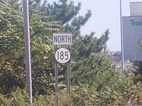 Shield for northbound Route 185
The alignment of Route 185 originates as Alternative F-1 and G-1 of the Liberty Harbor–Route 169 Feeder Arterial, proposed in 1977 during the construction of the New Jersey Route 169. The alignment was supposed to fork off of Route 169 near Interchange 14A on the Newark Bay Extension, and parallel the extension through the Greenville Railroad Yards. The alignment would parallel Caven Point Road to the south and through the Metropolitan Tank Port before ending at Interchange 14B in Jersey City. The alignment. The original alignment proposed, Alternative G-4, was to have the freeway run along the alignment of Caven Point Road parallel to the Newark Bay Extension into the Metropolitan Tank Port, but prior to the Final Environmental Impact Statement, the proposal was dropped. The alignment was designed to help serve existing and proposed industry and divert truck traffic from local streets. The alignment of the new arterial was proposed to be 2.75 miles (4.43 km) with four travel lanes (two in each direction) designed for hourly volume of 3090 vehicles.[3]
Although most of the arterial was proposed as an at-grade highway, the interchange with Route 169 would not be so the highway can be safe through the Greenville Railroad Yard on a viaduct. The right-of-way for the new Liberty Harbor arterial would be 110 feet (34 m) wide and terminate at Interchange 14B, although there was the possibility of turning it into the new Hudson River Route, a project being studied by the New Jersey Department of Transportation.[3]
Construction and recent history
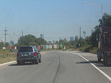 Route 185 approaching the terminus at Linden Avenue in Jersey City. This is only milepost 0.65 miles (1.05 km), 23% of the proposed length
Route 185 was first conceived by the state legislature in 1976, a when an addition to the state statues was passed for a route from Harbor Drive to an intersection with Bayview Avenue in Jersey City. The law passed on July 22, 1976 and the original highway had no designation.[4] The route opened on February 25, 1988 from Route 169 (now NJ 440) to an intersection with Linden Avenue, only 23% of its proposed alignment.[5] In 1996, Conti Enterprises was hired for a construction project involving NJ 169 and NJ 185. Along with the widening of NJ 169 to four lanes, this also involved getting acceleration lanes on NJ 185 for drivers heading towards Upper New York Bay.[6]
In September 2008, the New Jersey Department of Transportation brought up the possibility of extending Route 185 to Bayview Avenue from its current northern terminus at Linden Avenue. Previous studies have said Route 185 could be extended, or the reverse with the Linden Avenue jog at Liberty State Park be removed. No future plans have been set yet for this truck effiecient plan.[7]
Major intersections
The entire route is in Jersey City, Hudson County.
Mile[1] Destinations Notes 0.00 Route 440Southern terminus of NJ 185. 0.12 Route 4400.65 Linden Avenue Northern terminus of NJ 185. 1.000 mi = 1.609 km; 1.000 km = 0.621 mi See also
 U.S. Roads portal
 New Jersey portal
References
- ^ a b New Jersey Route 185 Straight Line Diagram from the New Jersey Department of Transportation
- ^ Yahoo! Inc. Yahoo! Maps – Overview map of NJ Route 185 (Map). Cartography by NAVTEQ. http://maps.yahoo.com/#mvt=h&lat=40.687378&lon=-74.078237&zoom=17&q1=40.688851%2C-74.083408&q2=40.683969%2C-74.09403. Retrieved July 11, 2009.
- ^ a b Route 169 Land Service Road from the Bayonne Bridge in Bayonne to the vicinity of Bayview Avenue in Jersey City, Hudson County, New Jersey., New Jersey Department of Transportation and United States Federal Highway Adminsistration, 1977
- ^ Route No. ... - Hudson County. New Jersey General Assembly. 1976.
- ^ Alpert, Steve (2009). "185". Alps' Roads. http://www.alpsroads.net/roads/nj/log/10.html#185. Retrieved July 13, 2009.
- ^ Projects: Route 169 and Route 185. Conti Enterprises Inc.. 1997. pp. 2.
- ^ "Transportation 2030: Jersey City Supplement". New Jersey Department of Transportation. September 2008. pp. 34. http://www.state.nj.us/transportation/works/njchoices/pdf/jerseycity.pdf. Retrieved July 13, 2009.
External links
Categories:- State highways in New Jersey
- Transportation in Hudson County, New Jersey


Wikimedia Foundation. 2010.