- Chilbolton
-
Coordinates: 51°09′25″N 1°26′19″W / 51.1569°N 1.4387°W
Chilbolton 
 Chilbolton
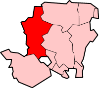
Chilbolton shown within HampshirePopulation 1,010 [1] OS grid reference SU392399 Parish Chilbolton District Test Valley Shire county Hampshire Region South East Country England Sovereign state United Kingdom Post town Stockbridge Postcode district SO20 Dialling code 01264 Police Hampshire Fire Hampshire Ambulance South Central EU Parliament South East England UK Parliament Romsey List of places: UK • England • Hampshire Chilbolton is a village and civil parish in Hampshire, England, near to Stockbridge. Its most notable feature is the Chilbolton Observatory situated on the disused RAF Chilbolton airfield. The parish church of St Mary the Less dates back to the 12th century, on the site of an earlier wooden church.
Chilbolton is recorded in the Domesday Book under the name Cilbodentune.References
- ^ "Parish Headcounts, Area: Chilbolton CP". Neighbourhood Statistics. Office for National Statistics. 2001. http://www.neighbourhood.statistics.gov.uk/dissemination/LeadTableView.do?a=3&b=795145&c=Chilbolton&d=16&e=15&g=452726&i=1001x1003x1004&k=Stockbridge&o=1&m=0&r=1&s=1204205347515&enc=1&dsFamilyId=779. Retrieved 2008-02-27.
External links
Towns, villages and hamlets in the Test Valley District of Hampshire, England  Abbotswood · Abbotts Ann · Abbotts Ann Down · Ampfield · Amport · Andover · Andover Down · Anna Valley · Appleshaw · Ashfield · Awbridge · Barton Stacey · Bossington · Braishfield · Broughton · Charlton · Chattis Hill · Chilbolton · Chilbolton Down · Clanville · Crampmoor · Dunbridge · Dunley · East Anton · Embley · East Cholderton · East Dean · East Tytherley · Faberstown · Faccombe · Finkley · Finkley Down · Forton · Fox Amport · Foxcotte · Freefolk · Fullerton · Fyfield · Goodworth Clatford · Gore End · Grateley · Hatherden · Hillyfields · Houghton · Houghton Down · Hurstbourne Tarrant · Kimbridge · Kimpton · King's Somborne · Knights Enham · Leckford · Lickenholt · Little Down · Little Hatherden · Little Somborne · Lockerley · Longparish · Longstock · Longstock Park · Lower Wyke · Marsh Court · Michelmersh · Middle Wallop · Monxton · Mottisfont · Nether Wallop · Newton Stacey · North Baddesley · North Houghton · Nursling · Over Wallop · Penton Corner · Penton Grafton · Picket Piece · Picket Twenty · Pill Heath · Plaitford · Quarley · Ragged Appleshaw · Ramridge Park · Red Post Bridge · Red Rice · Redenham · Romsey · Sherfield English · Shipton Bellinger · Shootash · Smannell · South Harewood · Stockbridge · Tangley · Thruxton · Up Somborne · Upper Clatford · Upper Enham · Vernhams Dean · Vernham Street · Wellow · West Tytherley · Wherwell · Wherwell Wood · WildhernCategories:
- Villages in Hampshire
- Test Valley
- Hampshire geography stubs

Wikimedia Foundation. 2010.