- Mynydd Carningli
-
Mynydd Carningli 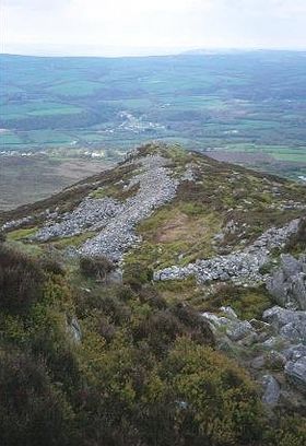
Mynydd CarningliElevation 347 m (1,138 ft) Prominence 233 m (764 ft) Parent peak Foel Cwmcerwyn Listing Marilyn Translation Angel–rock mountain (Welsh) Pronunciation Welsh: [ˈmənɪð kaːrˈnɪŋli] Location Location Pembrokeshire,  Wales
WalesRange Preseli Hills Topo map OS Landranger 145 OS grid SN062371 Geology Last eruption 450 million years ago Mynydd Carningli is a small mountain or hill near the town of Newport in Pembrokeshire, southwest Wales.
It is less than 400 m high, but it is close to the coast and dominates the surrounding countryside. It is easy to climb but has a rocky summit and a steep scree slope on its southern and eastern flanks. The mountain has always had sacred associations — according to legend Saint Brynach (a local saint) used to climb to the summit to find serenity, to pray and to "commune with the angels" in the 5th century. In some old texts and maps the mountain is called Carn Yengly or Carnengli, which are probably corruptions of Carn Engylau. Strictly, this would be translated as "the rocky summit of the angels." However, this derivation of the name is not universally agreed[1].
Brian John's "Angel Mountain Saga" of five volumes, recounts the life of Mistress Martha Morgan of Plas Ingli. These books were published at the rate of one per year, 2001–2005. The mountain is the heroine's personal sanctuary.
There was once a little "mountain railway" on Carningli, carrying broken stone from a small quarry down to a crushing plant on the Cilgwyn Road. Some railway sleepers can still be found in the turf, but otherwise the only traces remaining are the two stone pillars that supported a cable drum — a cable was used to control the descent of the loaded wagons as they rolled downhill, and then to pull the empty ones back up again. This little industry was abandoned before 1930.
The summit of the mountain supports a complex Iron Age hillfort called Carningli hillfort.
See also
References
- ^ B G Charles, The Place-names of Pembrokeshire, NLW, 1992, ISBN 0-907158-58-7, page 163
External links
 Media related to Mynydd Carningli at Wikimedia Commons
- www.geograph.co.uk : photos of Mynydd Carningli and surrounding area
- Carningli photo gallery [1]
- Carningli slide show [2]
- Carningli guide [3]
Categories:- Geography of Pembrokeshire
- Marilyns of Wales
- Mountains and hills of south Wales

Wikimedia Foundation. 2010.