Cossatot River

Cossatot River
Cossatot River

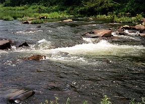
The Cossatot River near Gillham Lake in Howard County, Arkansas
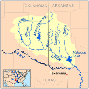
The Little River watershed
Origin Ouachita Mountains
Mouth Gillham Lake, Howard County, Arkansas

The Cossatot River is an 89-mile-long (143 km)[1] river in the U.S. state Arkansas.

Cossatot comes from the French cassé-tête which translates roughly to skull crusher. The Cossatot is known as a difficult (class II - IV+) whitewater stream to canoeists and kayakers and a section at Cossatot Falls in Howard County, Arkansas has been called "the most challenging section of whitewater between the Smokies and the Rockies," though there are many more challenging runs in the state of Arkansas, such as Richland Creek, Crooked Creek or the Upper Buffalo (Hailstone run). An 11-mile (18-km) section including Cossatot Falls is designated as the Cossatot River State Park-Natural Area. Cossatot Falls is a series of back-to-back class III-IV+ rapids that drops around 40 feet in 1/8 of a mile. Rapid names are Cossatosser (class II+), Eye Opener, B.M.F. (class III), Washing Machine (class IV+), Whiplash, (class III+), and Shoulderbone (class II), with Deer Camp Rapid (class III), Devil's Hollow Rapid (class III+), and Devil's Hollow Falls (class IV) located downstream of the Falls area. Zigzag (Class III) and the Esses (class III) are other notable rapids on the Cossatot, located above the Falls. Whitewater rapid classes vary depending on water level. At certain higher levels near flood state, almost all of the Cossatot Falls turn into one long rapid.

The Cossatot begins in the Ouachita Mountains southeast of Mena, Arkansas. The river flows through the Ouachita National Forest and then in a generally southerly direction until it empties into Gillham Lake. After exiting Gillham Lake the river becomes leisurely until it joins with the Little River at the site where it empties into Millwood Lake.

The World War II fleet oiler USS Cossatot (AO-77) is named after this river.

Camping sites are located near the Cossatot Falls area, and at the nearby Brushy Creek Recreation area.

The Cossatot is listed as a National Wild and Scenic River and an Arkansas Natural and Scenic River.

See also

  • List of Arkansas rivers

References

  1. ^ "The National Map". U.S. Geological Survey. http://viewer.nationalmap.gov/viewer/. Retrieved March 8, 2011. 


Wikimedia Foundation. 2010.

Игры ⚽ Нужно сделать НИР?

Look at other dictionaries:

  • Cossatot River State Park-Natural Area — is a 5,383 acre (2,178 ha) state park and designated natural area located in Howard County, Arkansas, United States. The park is managed jointly by the Arkansas Department of Parks and Tourism and the Arkansas Natural Heritage Commission.… …   Wikipedia

  • Cossatot Community College — of the University of Arkansas Motto Learn More, Live Better. Established 1975 Type Community College Chancellor …   Wikipedia

  • Little River (Red River) — The Little River is a tributary of the Red River, about 220 mi (355 km) long, in southeastern Oklahoma and southwestern Arkansas in the United States. Via the Red, it is part of the watershed of the Mississippi River.CourseThe Little River rises… …   Wikipedia

  • USS Cossatot (AO-77) — was a United States Navy World War II T2 tanker which served as a fleet oiler launched as SS Fort Necessity February 28, 1943 by Sun Shipbuilding and Dry Dock Co., Chester, Pa., under a Maritime Commission contract; sponsored by Mrs. W. Taylor;… …   Wikipedia

  • Gillham Lake — Infobox lake lake name = Gillham Lake image lake = caption lake = image bathymetry = caption bathymetry = location = Howard County, Arkansas coords = coord|34|12|56|N|94|13|50|W|type:waterbody region:US|display=inline,title type = reservoir… …   Wikipedia

  • List of rivers of Arkansas — List of rivers in Arkansas (U.S. state).For a list of dams and reservoirs in Arkansas, see List of Arkansas dams and reservoirsBy Drainage BasinThis list is arranged by drainage basin, with respective tributaries indented under each larger stream …   Wikipedia

  • National Register of Historic Places listings in Sevier County, Arkansas — Location of Sevier County in Arkansas This is a list of the National Register of Historic Places listings in Sevier County, Arkansas. This is intended to be a complete list of the properties on the National Register of Historic Places in Sevier… …   Wikipedia

  • Ouachita National Forest — IUCN Category VI (Managed Resource Protected Area) Location Arkansas / Oklahoma, USA Nearest city …   Wikipedia

  • Daisy State Park — is a state park in southwestern Arkansas administered by the Arkansas Department of Parks and Tourism. Daisy State Park is located in Daisy, Arkansas in the foothills of the Ouachita Mountains at the northern end of Lake Greeson, a 7,000 acre… …   Wikipedia

  • Liste der Flüsse in den Vereinigten Staaten — Die folgende Liste zeigt die Flüsse in den Vereinigten Staaten. A Alabama River Alabama Allegheny River Pennsylvania, New York Alsea River Oregon Altamaha River Georgia Amargosa River Kalifornien American River Kalifornien Anacostia River… …   Deutsch Wikipedia

Share the article and excerpts

Direct link
Do a right-click on the link above
and select “Copy Link”