- Muldentalkreis
-
Muldentalkreis — District — 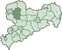
Country  Germany
State Saxony Adm. region Leipzig Disbanded 2008-08-01 Capital Grimma Area - Total 892.62 km2 (344.6 sq mi) Population (2001) - Total 135,459 - Density 151.8/km2 (393/sq mi) Time zone CET (UTC+1) - Summer (DST) CEST (UTC+2) Vehicle registration MTL Website http://www.lra-mtl.de The Muldentalkreis is a former district in the Free State of Saxony, Germany. It was bounded by (from the north and clockwise) the districts Delitzsch, Torgau-Oschatz, Döbeln, Mittweida and Leipziger Land.
Contents
History
The roots of the district date back to the Amt Grimma, which was formed in 1832 to 1838, and was later renamed Kreis (district). The city of Wurzen left the district 1926-1945 as a district-free city. In 1952 the area around Wurzen was split off from the district Grimma. This was reverted in 1994 when the two previous districts Grimma and Wurzen were merged again. A few municipalities from other districts around Bad Lausick were added as well. In August 2008, it became a part of the new district of Leipzig.
Geography
The district is named after its major river, the Mulde - the name Muldental means valley of the Mulde. The Mulde is formed in the south of the district by its two confluents Freiberger Mulde and Zwickauer Mulde, and flows through the district in south-north direction.
Coat of arms
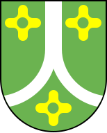
The silver lines in the coat of arms symbolize the river Mulde and its two source arms. The green color symbolizes the forests of the district, and the three flower symbols stand for the two previous districts and the municipalities from other districts which were merged together to form the current district. Towns and municipalities
Towns Municipalities External links
- Official website (German)
 Urban and rural districts in the Free State of Saxony in Germany
Urban districts Rural districts Former urban districts Former rural districts Annaberg · Aue-Schwarzenberg · Chemnitzer Land · Delitzsch · Döbeln · Freiberg · Kamenz · Leipziger Land · Löbau-Zittau · Mittlerer Erzgebirgskreis · Mittweida · Muldentalkreis · Niederschlesischer Oberlausitzkreis · Riesa-Großenhain · Sächsische Schweiz · Stollberg · Torgau-Oschatz · Weißeritzkreis · Zwickauer LandCategories:- Former districts of Saxony

Wikimedia Foundation. 2010.