- Noar Hill
-
Noar Hill, near Selborne in East Hampshire, is best known for its nature reserve.
Contents
Etymology
Nore is an obsolete spelling of nor', north. Noar is a variant of nore.
Topography and management
The hill is at 51°04′30″N 0°56′00″W / 51.075°N 0.9333333°W (Ordnance Survey reference SU745315) and lies in the parish of Newton Valence, in the East Hampshire Area of Outstanding Natural Beauty..
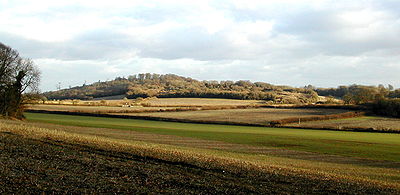
It forms one of the westerly outposts of the chalk hills called the South Downs, and rises to a maximum height of about 210 metres above sea-level. The western and northern flanks slope fairly gently, but the eastern and southern flanks in places reach a gradient exceeding 60%.
Gilbert White, in his Natural History of Selborne, [1] says of Noar Hill:
"At each end of the village [Selborne], which runs from south-east to north-west, arises a small rivulet: that at the north-west end frequently fails: but the other is a fine perennial spring little influenced by drought or wet seasons, called Well-head. This breaks out of some high grounds adjoining to Nore Hill, a noble chalk promontory, remarkable for sending forth two streams into two different seas. The one to the south becomes a branch of the Arun, running to Arundel, and so falling into the British channel: the other to the north." (Letter I to Thomas Pennant.)
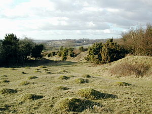
The western flanks and much of the summit are given over to arable fields. A smaller part of the summit, 20 hectares (about 49 acres) known as High Common, is covered with downland grasses and scrub. The northern, eastern and southern flanks are covered by deciduous woodland dominated by beech. Such beechwoods on steep hills in East Hampshire are termed "hangers".
High Common is the site of mediaeval chalk-workings – chalk was dug out and spread on nearby fields as fertilizer. The excavations have left an irregular network of pits and hollows of varying size, depth, and steepness. Because the ground is so uneven, High Common remained unploughed for centuries and was only used for grazing. It retains the ancient chalk downland flora which elsewhere has largely been lost.
Its importance was officially recognized in 1982, when it was declared a nature reserve. It also has SSSI status. The reserve is managed by the Hampshire and Isle of Wight Wildlife Trust. When first declared, about two-thirds of the reserve were covered by scrub, a great deal of which has now been removed, though management today still requires constant scrub-control and regular coppicing of hazel. Grazing is used to maintain the close-cropped turf on which many of the other plants and insects depend.
Flora
The chalk-diggings not only made High Common unsuitable for ploughing, but also left bare chalk exposed. The many inclines and aspects of the disused pits provide different microclimates, all of which add to the variety of the flora.
Noar Hill is noted for its calcicoles (chalk-dwelling plants). These include Hairy Rock-cress Arabis hirsuta, Dropwort Filipendula vulgaris, Harsh Downy-rose Rosa tomentosa, Pale Flax Linum bienne, Common Milkwort Polygala vulgaris, Marjoram Origanum vulgare, wild thyme (two species: Large Thyme Thymus pulegioides and Th. polytrichus), Eyebright Euphrasia nemorosa, and Clustered Bellflower Campanula glomerata.
Small-leaved Sweet-briar Rosa agrestis was recorded in 1978. Four bushes of Box Buxus sempervirens growing on the landslip are considered by Dr Francis Rose to be native. Early Gentian Gentianella anglica has been found (1951, 1988, 1994) on the bare chalk-scree. The parasitic Knapweed Broomrape Orobanche elatior is regularly recorded. Juniper Juniperus communis thrives; and in spring there is a beautiful display of Cowslip Primula veris.
There are occasional findings of Dragon's-teeth Tetragonolobus maritimus and Fern-grass Catapodium rigidum.
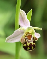
However, the chief glory of Noar Hill derives from its orchids. At least eleven species have been identified:
- Twayblade (Listera ovata)
- Autumn Lady's Tresses (Spiranthes spiralis)
- Musk Orchid (Herminium monorchis)
- Pyramidal Orchid (Anacamptis pyramidalis)
- Fragrant Orchid (Gymnadenia conopsea, including ×Dactylodenia st-quintinii)
- Frog Orchid Coeloglossum viride, including ×Dactyloglossum mixtum)
- Common Spotted Orchid (Dactylorhiza fuchsii')
- Southern Marsh Orchid (D. praetermissa)
- Early Purple Orchid (Orchis mascula)
- Fly Orchid (Ophrys insectifera)
- Bee Orchid (O. apifera)
The colony of musk orchids runs to approximately 10,000 spikes and is of national importance.
High Common, surrounded by botanically impoverished farmland, provides both a refuge for chalk downland species and a reservoir from which recolonization of nearby areas is possible. The habitat restoration being undertaken at Selborne Common may be one beneficiary.
Fauna
Noar Hill is home to the only British species (Chirocephalus diaphanus) of the curious Fairy Shrimp, which lives in puddles on the tracks and survives as eggs when the mud dries. Glow-worms Lampyris noctiluca are occasionally seen over the reserve on summer evenings. Grasshoppers abound, including the Rufous Grasshopper Gomphocerippus rufus.
The butterflies include Marbled White Melanargia galathea, Brown Argus Aricia agestis, Duke of Burgundy Hamearis lucina, Brown Hairstreak Thecla betulae, and Holly Blue Celastrina argiolus, besides large numbers of more common species.
The reserve is a good place to look for Slow-worms Anguis fragilis. It supports breeding Turtle Doves Streptopelia turtur; and Green Woodpeckers Picus viridis, which are fond of feeding on ants, are frequent. Several pairs of Common Buzzards Buteo buteo are resident in the area and the rabbits on High Common are a favourite prey. Hen Harrier Circus cyaneus is an occasional winter visitor. For some reason – perhaps the abundance of rosehips – Bullfinches Pyrrhula pyrrhula are always to be found upon the hill.
External links
References
- Brewis, Anne, et al. (1996) The Flora of Hampshire. Harley Books, ISBN 0-946589-53-4
Sites of Special Scientific Interest in Hampshire Basingstoke Canal · Beacon Hill, Warnford · Blackwater Valley · Boulsbury Wood · Bourley and Long Valley · Burghclere Beacon · Butser Hill · Catherington Down · Cheesefoot Head · Chichester Harbour · Dibden Bay · Ebblake Bog · Fleet Pond · Foxlease And Ancells Meadows · Galley Down Wood · Greywell Tunnel · Hurst Castle And Lymington River Estuary · Itchen Navigation · Ladle Hill · Langstone Harbour · Lymington River · Lymington River Reedbeds · Mottisfont Bats · New Forest · Noar Hill · Old Winchester Hill · Pamber Forest and Silchester Common · Portsmouth Harbour · River Avon System · River Itchen · River Test · Selborne Common · Southampton Common · Sowley Pond · St. Catherine's Hill · Trodds Copse · Woolmer Forest
Neighbouring areas: Berkshire · Dorset · Isle of Wight · Surrey · West Sussex · Wiltshire
Categories:- Sites of Special Scientific Interest in Hampshire
- Nature reserves in Hampshire
Wikimedia Foundation. 2010.


