- Cliffy Island Lighthouse
-
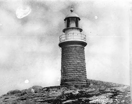
Cliffy Island Lighthouse 
Cliffy Island Lighthouse, 1917 Location Bass Strait, 17 nmi S of Port Albert, Victoria, Australia Coordinates 38°57.2′S 146°42.4′E / 38.9533°S 146.7067°ECoordinates: 38°57.2′S 146°42.4′E / 38.9533°S 146.7067°E Year first constructed 1884[1] Year first lit 1884 Automated 1971 Deactivated Active Foundation Granite Construction Granite Tower shape Round Markings / pattern Unpainted round granite tower, lantern and gallery painted white Height 12 m Focal height 52 m Original lens Fresnel lens Intensity 15,300 cd Range 18 nmi Characteristic White flash every 5 seconds Admiralty number K2500 NGA number 7204 ARLHS number AUS-059 The 'Cliffy Island Lighthouse is located atop Cliffy Island, a steep-sided island which is the summit of a granite submarine mountain in the Bass Strait. Cliffy Island is located about 32 kilometres diectly south of Port Albert, and roughly 38 kilometres to the northeast of Wilsons Promontory Lighthouse in Victoria, Australia. The lighthouse warns approaching vessels of rocks in Bass Strait by emitting a flash of white light every five seconds. The focal plane of the lightsource and Fresnel lens is situated 52 metres above sea level.[2] The site is managed by the Victoria Department of Conservation and Natural Resources, while the lighthouse itself is operated by the Australian Maritime Safety Authority (AMSA). The island is accessible only by helicopter, and the entire site is closed to the public.[1]
Contents
History
Cliffy Island lighthouse was constructed on site in 1884 from granite quarried on the island. In addition to the lighthouse, there was a stone cottage for the head lighthouse keeper and his family. This structure was nearly identical to the one at Cape Nelson (they were both built in the same year, probably from the same set of blueprints). There was also a duplex wooden structure that served as the residence of the two assistant keepers and their families.[3] The keeper's houses were demolished in 1971, when the lighthouse was automated; the stone walls that surrounded the houses remain.[1]
Adjacent Lighthouses
- South West - Wilsons Promontory Lighthouse
- North East - Lighthouse at Cape Conran Coastal Park
- North East - Point Hicks Lighthouse
See also
- List of lighthouses and lightvessels in Australia
References
- ^ a b c Rowlett, Russ. "Lighthouses of Australia: Victoria". The Lighthouse Directory. University of North Carolina at Chapel Hill. http://www.unc.edu/~rowlett/lighthouse/vic.htm.
- ^ Macdonald MS (2003). "Lighthouses of Victoria: The Cliffy Island Lighthouse". Knox City, Victoria: Lighthouses of Australia Inc.. http://www.lighthouse.net.au/lights/VIC/Cliffy%20Island/Cliffy%20Island.htm. Retrieved 2011-01-13.
- ^ Breen W (2006). "Memories of Cliffy Island". Lighthouses of Australia Inc. Bulletin 9 (6). http://www.lighthouse.net.au/lights/bulletin/0612/cliffy_island.htm. Retrieved 2011-01-13.
Further reading
- Diving Australia by Peter Stone
- From Dusk Till Dawn by Gordon Reid
- The Lighthouses of Victoria by Dacre Smyth
- The Melbourne Truth
External links
- Map showing location of Cliffy Island lighthouse
- Parks Victoria - Parks Victoria is the custodian of a diverse estate of significant parks in Victoria
- Searle, Garry. "List of Lighthouses - Victoria". Lighthouses of Australia. SeaSide Lights. http://www.seasidelights.com.au/state.asp?fState=VIC.
Lighthouses of Victoria Cape Conran · Cape Liptrap · Cape Nelson · Cape Otway · Cape Schanck · Cape Woolamai · Citadel Island · Cliffy Island · Gabo Island · Gellibrand pile light · Griffiths Island · Lady Bay Lower · Lady Bay Upper · Mount Barkly · Point Grant · Point Hicks · Point Lonsdale · Queenscliff High Light · Queenscliff Low Light · Round Island · Schnapper Point · Split Point · Whalers Bluff · Williamstown · Wilsons PromontoryCategories:- Lighthouses in Victoria
- 1884 establishments in Australia
Wikimedia Foundation. 2010.