- Milcovul
-
Milcovul — Commune — 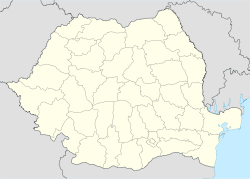
 Milcovul
Coordinates: 45°39′N 27°15′E / 45.65°N 27.25°E Country  Romania
County Vrancea County Population (2002)[1] 8,593 Time zone EET (UTC+2) - Summer (DST) EEST (UTC+3) Milcovul or Milcov (Hungarian: Milkó) is a commune in Vrancea County, Romania. It is located in the historical region of Moldavia. It is composed of two villages, Lămoteşti and Milcovul, and also included Gologanu and Răstoaca before these became separate communes in 2004.
In 1227 Milcov became the seat of the Diocese of Cumania, a Roman Catholic bishopric which served the Cumans and the Teutonic Knights in the Burzenland. The diocese was destroyed during the Mongol invasion of Europe in 1241.
Coordinates: 45°39′N 27°15′E / 45.65°N 27.25°E
References
- ^ Romanian census data, 2002; retrieved on March 1, 2010
Cities 
Towns Communes Andreiaşu de Jos · Băleşti · Bârseşti · Bilieşti · Bogheşti · Boloteşti · Bordeşti · Broşteni · Câmpineanca · Câmpuri · Cârligele · Chiojdeni · Ciorăşti · Corbiţa · Coteşti · Dumbrăveni · Dumitreşti · Fitioneşti · Garoafa · Goleşti · Gologanu · Gugeşti · Gura Caliţei · Homocea · Jariştea · Jitia · Măicăneşti · Mera · Milcovul · Moviliţa · Năneşti · Năruja · Negrileşti · Nereju · Nistoreşti · Obrejiţa · Paltin · Păuleşti · Păuneşti · Ploscuţeni · Poiana Cristei · Popeşti · Pufeşti · Răcoasa · Răstoaca · Reghiu · Rugineşti · Sihlea · Slobozia Bradului · Slobozia Ciorăşti · Soveja · Spulber · Străoane · Suraia · Tâmboeşti · Tănăsoaia · Tătăranu · Tulnici · Ţifeşti · Urecheşti · Valea Sării · Vânători · Vârteşcoiu · Vidra · Vintileasca · Vizantea-Livezi · Vrâncioaia · Vulturu
Categories:- Vrancea County geography stubs
- Communes in Vrancea County


Wikimedia Foundation. 2010.