- Borča
-
Борча
Borča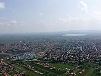
Country:  Serbia
Subdivision: City of Belgrade, Palilula municipality Location: 44.87° North, 20.45° East Population:
2002
35,150Area code: + 381(0)11 Postal code: 11211 License plates: BG Borča (Serbian Cyrillic: Борча, pronounced [bɔ̂ːrt͡ʃa]) is a suburban settlement of Belgrade, the capital of Serbia. It is located in the Belgrade's municipality of Palilula.
Contents
Location
Borča is located just 8 kilometers north of the downtown Belgrade, in the Banat section of the municipality of Palilula at 44.87° North, 20.45° East, at an altitude of 78 meters. It stretches between the Zrenjaninski put road (which connects Belgrade to the town of Zrenjanin in Vojvodina) and the slow streams of Pretok, Sebeš and Vizelj, which flows through the middle of the marshy area of Pančevački Rit, the northern part of the municipality of Palilula.
As Borča developed, it stretched along the Zrenjaninski put to the south (Krnjača's neighborhood of Dunavski Venac) and to the north (suburban settlement of Padinska Skela).
History
Early history
Earliest remains in the vicinity of modern settlement of Borča are from the bronze and iron age, but the medallions, figurines and coins from the 3rd and 4th century BC are also found. Because of the marshy area, not much is preserved, but the remains which confirm presence of the Sarmatians (including Iazyges) and Romans were found.
Kingdom of Hungary and Ottoman Empire
Borča was mentioned for the first time in 1375 under name Barcsa (or Bercse). Settlement was under administration of the Kingdom of Hungary, although its name imply possible Slavic root (Name Barcsa possibly derived from Slavic word "bara" meaning "swamp" in English, indicating the settlement's position in the swampy area of Pančevački Rit). In 1537 it was captured by the Ottomans, included into the Sanjak of Smederevo and granted the waqf status. Already in 1567 Borča was predominantly settled by the Serbs when famous Jazak Gospel was written in it. During the Habsburg-Ottoman wars, Borča became center of the Ottoman border zone and was heavily fortified (Porača fort) after the Treaty of Karlowitz but was still conquered by the Habsburgs in 1717 and by the Treaty of Passarowitz in 1718 was formally handed over to the Habsburg Monarchy.
Habsburg Monarchy
After the Treaty of Belgrade in 1739 Habsburg Monarchy obliged to tear down the fortifications, but due to the outbreak of the plague in 1743 the entire village of Borča was burned to the ground. The new settlement emerged around the sentry post of Stara Borča (Alt Borcsa) in 1794 which became center of a municipality as part of the Banat Krajina, a section of the Habsburg Military Frontier.
In 1848-1849, Borča belonged to the Serbian Vojvodina, a Serb autonomous region within Habsburg Monarchy, but in 1849 it was again placed under administration of the Military Frontier. After transformation of Habsburg Monarchy into the Austria-Hungary in 1867 and abolition of the Military Frontier on 27 June 1873 Borča became part of the Hungarian half of the monarchy, as part of the Pančevo district within Torontál comitatus, seated in modern Zrenjanin. In 1910, ethnic Serbs were in an absolute majority in Borča.[1] Other ethnic groups in the settlement included Germans, Hungarians and Romanians. Borča was shortly taken by the Serbian army during World War I (6 September - 14 October 1914).
Yugoslavia and Serbia
As Pančevački Rit is a floodplain, during extremely high levels of the Danube (especially in 1826, 1888 and 1924), entire area and settlements in it were completely flooded turning the marsh into a large lake. It was recorded that during the floods of 1924, rescue ships had to maneuver between the telephone poles and that dead were buried from the boats. In 1929-1933 a 89 kilometer-long embankment was built which protected Borča from further floodings. At the same time, road and railway connecting Borča to Belgrade were also built.
After the collapse of Austria-Hungary in 1918, Borča became part of the Kingdom of the Serbs, Croats and Slovenes (future Yugoslavia), being taken by the Serbian army on 9 November 1918. From 1918 to 1922, it was part of the Banat county, from 1922 to 1929 part of the Belgrade oblast, and from 1929 to 1941 part of the Belgrade City Administration (the District of Pančevo). Between 1941 and 1944 it was occupied by German troops and included into German-ruled autonomous region of Banat, which was a part of Serbia.
In 1949 the municipality was disbanded and the entire area of Pančevački Rit became IX Raion of Belgrade. Borča got its own municipality again on 30 May 1952 but in 1955 with municipalities of Ovča, Krnjača and Padinska Skela merged into one named Krnjača. In turn, this municipality was annexed to the Belgrade's municipality of Palilula in 1965.
Population
Since 1960s Borča began a massive development with rapid population growth having an estimated population of 38,281 on 31 December 2007 (35,150 by the last official census in 2002).
Population of Borča in various time periods:
- 1727 - 39 households
- 1843 - 675
- 1859 - 124 households
- 1910 - 1,535
- 1921 - 1,396
- 1931 - 1,724
- 1948 - 3,532
- 1953 - 3,384
- 1961 - 4,330
- 1971 - 9,487
- 1981 - 18,549
- 1991 - 26,044 (de facto)
- 1991 - 26,895 (de jure)
- 2002 - 35,150 (de facto)
- 2002 - 35,909 (de jure)
- 2007 - 38,281 (de facto)
Population of 1910 is an official Austro-Hungarian census data, 1921–2002 are official Yugoslav and Serbian census data, 2007 is an estimate. Following the official data, Borča is the largest single suburb of Belgrade. However, unofficial estimates put Kaluđerica in first place.
Ethnic structure
Ethnic structure of Borča (census 2002):
- Serbs = 30,834 (87.72%)
- Roma = 1,296 (3.69%)
- Yugoslavs = 474 (1.35%)
- Gorani = 464 (1.32%)
- Muslims = 271 (0.77%)
- Macedonians = 240 (0.68%)
- Croats = 232 (0.66%)
Neighborhoods
As one of the largest suburbs of Belgrade and a large settlement in its own right, Borča developed several sub-neighborhoods of its own. Officially, Borča is divided into three "local communities" (mesna zajednica), sub-municipal administrative units: Stara Borča (foremerly Borča I), Borča Greda (formerly Borča II) and Nova Borča (formerly Borča III). Most of Borča is grouped into centers (Centar I to V), which are sometimes referred to as Borča I to V (Centar I = Borča I, etc).
Stara Borča
Local community of Stara Borča (Old Borča) occupies the entire southern section of the settlement. It extends on both sides of Zrenjaninski put and comprises most diverse neighborhoods of Borča: the original, oldest section in the south-west, those closest to Belgrade, easternmost sections whwich extends to Ovča and the south-western extension in the direction of the Danube. According to the 2002 population census, it had a population of 13,624.
- Atovi (Атови, "horses"); easternmost extension, close to Ovča.
- Centar I (Центар Ι); central part of Borča, mainly bounded by the streets of Ivana Milutinovića, Lička and Narodnog fronta. It borders the neighborhoods of Stara Borča on the west, Sebeš on the east.
- Irgot (Иргот); south-western part of Stara Borča. It is located around the church, in the curve made by the Vizelj river, south of the Borčanskih žrtava street.
- Popova Bara (Попова бара; "priest's pond"); east-central and east-southern extension, across the Zrenjaninski put. Consists of two sections, northern, around the Androvačka street (formerly, Popova bara) and southern, on the northern bank of the Sebeš river, while the central bart in between is still mainly unurbanized.
- Sebeš (Себеш); southern extension which makes one continuous built-up area with Dunavski Venac and, further to the south, Krnjača. It is also called Mokri Sebeš (Wet Sebeš) or Borčanski Sebeš. Named after the river-turned-canal Sebeš which flows into Vizelj further south and marks the southern border of the neighborhood but also of the entire Borča. It extends into Stara Borča and Centar I on the west, Zrenjaninski Put on the north and Popova Bara on the east, across the road of Zrenjaninski put.
- Slatina (Слатина; "salt marsh"); eastern extension, developed along the road to Ovča. As a curiosity, majority of the sreets in the neighborhood, previously known all as Slatina with different numbers added to distinguish them, are recently being named after (ancient) Greek toponyms: Epirus, Morea, Beotia, Angora, Ephesus, Milet, Nicaea, Pergamon, Cappadocia, Delphi, Corinth, Troy, Volos, Sparta, Antioch, Epidaurus, Phocis, Pilos, etc.
- Stara Borča (Стара Борча); as the name suggests, the oldest part of the entire settlement. It occupies the south-west corner, south of the Jugoslovenska street and the Square of Liberation. It borders the neighborhoods of Centar III on the north, Centar I on the north-east, Sebeš on the west and extends into Crvenka further into the south-west. Generally considered the calmest part of Borča, it is mosly made of individual residential houses, resembling in form other typical Pannonian's settlements.
- Vihor (Вихор; "windstorm"); eastern extension, close to Ovča.
Nova Borča
Local community of Nova Borča (New Borča) occupies the east-central corner of Borča. Though the area of this local community is the smallest of all three, it is the mostly populous one, with a population of 14,875 by the 2002 census. Also, unlike Stara Borča and Borča Greda, it comprises only one sub-neighborhood, Centar III.
- Centar III (Центар ΙII); entire settlement is constructed as a series of a parallel, half-circular streets: Ratnih vojnih invalida, Bele Bartoka, Privrednikovih pitomaca, Prelivačka. It extends into Stara Borča and Centar I on the south, Centar II on the east and Borča Greda on the north-east. Northern and western border of Centar III is marked by the Pretok canal and an unurbanized area across it, while in the south-west the neighborhood meets the Vizelj river. West, right across the Vizelj is occupied by the sport fields of the BSK Borča football club. Cemetery and open green market (new one, Nova pijaca) are located in the neighborhood.
Borča Greda
Local community of Borča Greda occupies the entire northern section of the settlement, extending on both sides of Zrenjaninski put. It had a population of 8,087 by the 2002 population census but the fastest growing sections of Borča, like Pretok or Mali Zbeg, are located in this local community.
- Borča Greda (Борча Греда); north-western extension of Borča, located between the street of Bratstva i jedinstva on the south and the Pretok canal on the north, with Ranka Miljića street running through the central parts of the municipality. It borders the neighborhoods of Centar IV in the north-west, Centar II on the north-east, Centar III on the south and Mali Zbeg on the north, across the Pretok. Neighborhood originates from the early 1950s and was originally named "Martinova Greda".
- Centar II (Центар ΙI); north-central extension, mostly bordered by the streets of Valjevskog odreda (western border), Bratstva i jedinstva (northern) and Ivana Milutinovića (southern). It extends into Centar III on the south-west, Borča Greda on the west, Center IV and Center V on the north and Zrenjaninski Put on the east. Open green market (old one, Stara pijaca) is located in the center of the neighborhood.
- Centar IV (Центар ΙV); smallest of all five centers. It occupies five buildings between the streets of Kovilovska, Severina Bijelića and Miladina Zarića. It extends into Borča Greda on the south-west, Centar V on the north-east and Mali Zbeg on the north, across the Pretok canal.
- Centar V (Центар V); located between the streets of Hopovska (west), Velikoremetska (south), Dunavske divizije (west) and the Pretok canal (north). It borders the neighborhoods of Centar IV on the south-west and Mali Zbeg on the north, across the Pretok. Because of its white buildings, it has been nicknamed "Sivi Dom" after very popular 1986 Serbian TV serial "Sivi dom" (literally, "grey home"), about a correctional facility in central Serbia.
- Guvno (Гувно; "threshing floor"); north-eastern extension of Borča, west of the Zrenjaninski road, in the section where a regional road for Ovča separates. It extends into Pretok on the north, Popova Bara in the south and Zrenjaninski Put, across the road of the same name.
- Mali Zbeg (Мали Збег; "little refuge"); the northernnmost part of Borča, across the canal and east of the road of Zrenjaninski put. Main streets in the neighborhood are Rastka Nemanjića (center) and Karlovačke mitropolije (south). One of the fastest growing parts of Borča. Large cemetery of "Zbeg" is located just north of the neighborhood. The Pretok canal, which makes southern border of Mali Zbeg, separates it from the neighborhoods of Borča Greda, Centar IV and Centar V.
- Pretok (Преток; "overspill"); north-eastern extension of Borča, west of the Zrenjaninski put. Main streets in the neighborhood are Kikindska and Mitra Trifunovića Uče. It developed in the late 1990s and was mostly settled by the refugees from Croatia and Bosnia and Herzegovina during Yugoslav wars, which made it another fast growing part of Borča. It borders the neighborhoods of Pretok on the south and Zrenjaninski Put on the east.
- Zrenjaninski Put (Зрењанински пут; "Zrenjanin road"); once easternmost part of Borča, located along the western side of the road of Zrenjaninski put, with massive expansion of the neighborhoods on the east (Pretok, Guvno, Popova Bara, Slatina, etc), Zrenjaninski Put basically becomes central part of the entire neighborhood. It espands during almost entire run of the Zrenjaninski put, connecting many other neighborhoods (Sebeš, Centar II, Centar V on the western side and Pretok, Guvno and Popova Bara on the eastern side).
References and sources
- Mala Prosvetina Enciklopedija, Third edition (1986), Vol.I; Prosveta; ISBN 86-07-00001-2
- Jovan Đ. Marković (1990): Enciklopedijski geografski leksikon Jugoslavije; Svjetlost-Sarajevo; ISBN 86-01-02651-6
- Uporedni pregled broja stanovnika 1948-2002 (2004); Republički zavod za statistiku; ISBN 86-84433-14-9
- Velimir Marinković (1975): Borča - naselje i škola;
- Enciklopedija Jugoslavije, Vol. I (1955); Jugoslavenski leksikografski zavod, Zagreb;
Notes
Categories:- Suburbs of Belgrade
- Former and proposed municipalities of Belgrade
- Populated places in Central Serbia
- Places in Serbian Banat

Wikimedia Foundation. 2010.