- Aletsch Glacier
-
Grosser Aletschgletscher 
Lower part of the glacierType Valley glacier Location Valais, Switzerland Coordinates 46°26′32″N 8°04′38″E / 46.44222°N 8.07722°ECoordinates: 46°26′32″N 8°04′38″E / 46.44222°N 8.07722°E Area 117.6 km² Length 23.6 km (2002) Thickness 900 m (Konkordiaplatz) Status Retreating The Aletsch Glacier (German: Aletschgletscher) or Great Aletsch Glacier (German: Grosser Aletschgletscher) is the largest glacier in the Alps. It has a length of about 23 km (14 mi) and covers more than 120 square kilometres (46 sq mi) in the eastern Bernese Alps in the Swiss canton of Valais. The Aletsch Glacier is composed by three smaller glaciers converging at Concordia, where its thickness is estimated to be near 1 km (3,300 ft). It then continues towards the Rhone valley before giving birth to the Massa River.
The whole area, including other glaciers is part of the Jungfrau-Aletsch Protected Area, which was declared a UNESCO World Heritage site in 2001.
Contents
Geography
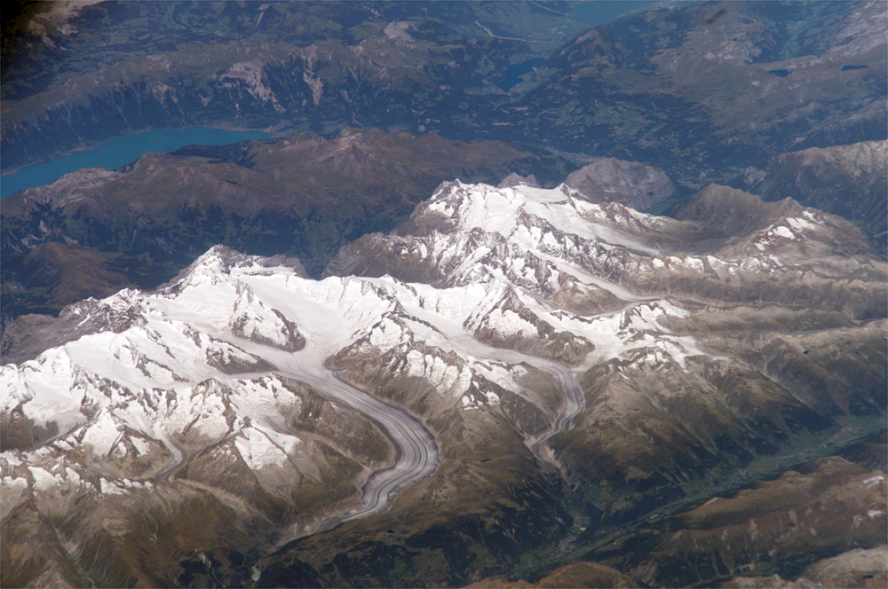
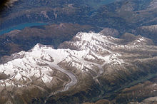 Jungfrau-Aletsch area from space
The Aletsch Glacier is one of the many glaciers located between the cantons of Berne and Valais on the Bernese Alps located east of the Gemmi Pass. The whole area is considered to be the largest glaciated area in western Eurasia.[1] The Fiescher and Aar glaciers lying on the east have similar extensions.
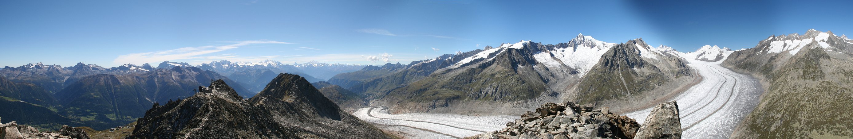
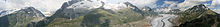 Aletch Panorama
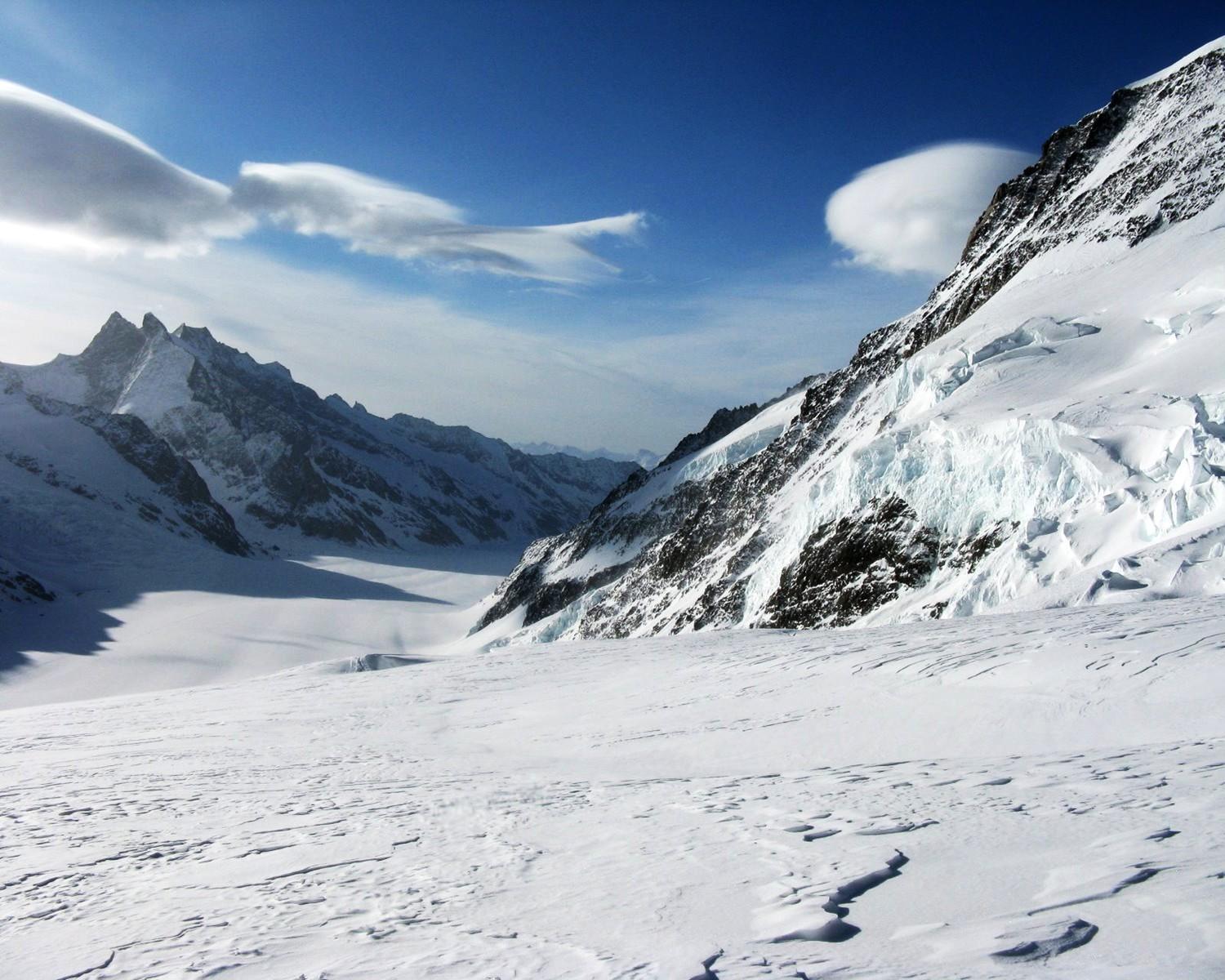
 Upper snows of the Jungfraufirn near Jungfraujoch
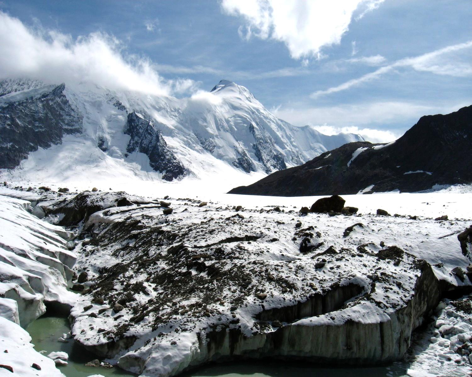
 At Concordia
 Near Märjelen
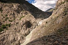 The beginning of the Massa river (the glacier is visible on the right)
Except the Finsteraarhorn, all the highest summits of the Bernese Alps are located within the drainage basin of the glacier. The Jungfrau and Mönch constitute the northern boundary; the Gross Fiescherhorn and Gross Wannenhorn lie on its east side; finally the culminating point, the Aletschhorn (4,195 meters/13,763 feet) is located on the west side.
Before reaching the maximum flow, three smaller glaciers converge at Concordia (German: Konkordiaplatz):- From the western mouth flows the Great Aletschfirn, which runs along the northern foot of the Aletschhorn and Dreieckhorn. The Aletschfirn is supplied from the north by three notable firns: the Ebnefluhfirn, the Gletscherhornfirn, and the Kranzberfirn. All of these Firns have their starting points at around 3800 m. From the Ebnefluhfirns to the Konkordiaplatz, the Aletschfirn is 9 km long and is on average about 1.5 km wide. From the west, the Aletschfirn flows over the 3173 m high glacier pass, the Lötschenlücke, connecting with the Langgletscher, and then into the Lötschental valley.
- From the northwestern mouth flows the Jungfraufirn. This firn in fact represents the straight continuation of the Aletsch Glacier, yet is the shortest of the three tributary glaciers. It has its origin on the southern flank of the Mönch, at the Jungfraujoch and at the eastern flank of the Jungfrau. Up to the Konkordiaplatz, the Jungfraufirn is a scarce 7 km long, and returns to flank the Kranzberg in the west and the Trugberg in the east. At its highest point, it is 2 km wide, and further down it is still a good 1 km wide.
- From the northern mouth flows the Ewigschneefeld (Eternal snow field), where its starting point takes the east flank of the Mönchs. In an elbow, it flanks from Trugberg in the west and the Fiescherhorn and Grünhorn in the east, flowing on to the Konkordiaplatz. Up to here, it is about 8 km long and averages about 1.2 km wide. The mouth at the Konkordplatz it follows over a rise with a descent from 25 to 30 percent; here, the glacier is sharply split. Against the north is the Ewigschneefeld over the snow-covered pass of the Lower Mönchsjochs (3529 m high), connected with the catchment area of the Lower Grindelwald Glacier. Through the Higher Mönchsjoch (3627 m high) between the Mönch and the Trugberg stands a connection to the Jungfraufirn.
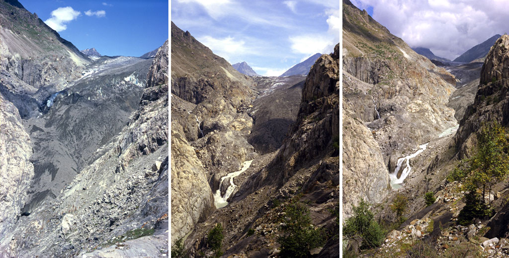
 The retreat of Aletsch Glacier in the Swiss Alps (situation in 1979, 1991 and 2002), due to global warming.
Below Concordia the glacier runs towards the valley of the Upper Rhône; on the left (east) side, near Bettmeralp, lies a glacier lake, Lake Märjelen (German: Märjelensee) (2,350 meters/7,711 feet); on the right side lie the glaciers of Mittelaletsch and Oberaletsch. At the end of the glacier, below the villages of Belalp (west) and Riederalp (east), begin the Massa river. The river flows through gorges and through the Lake Gibidum before reaching the Rhone near Brig.
Tourism
The area of the Aletsch Glacier and some surrounding valleys is on the UNESCO World Heritage list, thus it is protected and the facilities are mostly restricted the external zones. The region between Belalp, Riederalp and Bettmeralp (which is called Aletsch Region) in Valais gives access to the lower part of the glacier. The Bettmerhorn and Eggishorn are popular view points and are accessible by cable car. The Massa river can be crossed since 2008 by a suspension bridge, thus allowing hikes between the left and the right part of the glacier.
The Jungfraujoch railway station (3,450 m) gives a direct access to the upper Aletsch Glacier as well as the normal route to the Jungfrau. It can be reached only from Interlaken in the canton Berne. Glacier tours can be done with the help of the Konkordia Hut or the Hollandia Hut, eventually reaching other glaciers in the massif.
On the Riederfurka, at 2,065 metres between Riederalp and the glacier, is located the historic Villa Cassel, former summer residence of many numerous famous and influential guests from the worlds of politics and finance. The house is now one of the centers of the environmental organization Pro Natura, which hosts a permanent exhibition about the site.[2]
Panorama Picture
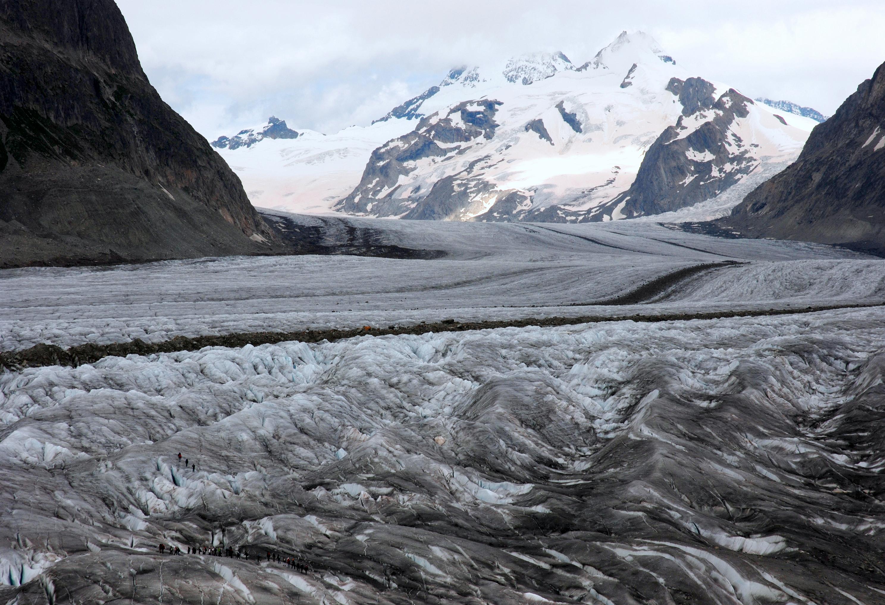
 Aletsch Glacier and Konkordiaplatz seen from Konkordia Hut (Sept. 2007)
Also at the mouth of the Konkordiaplatz from the east is the small but important Grüneggfirn (3 km long and averaging 600 m wide). This firn is connected in the over the glacier pass Grünhornlücke (3280 m high) to the Fiescher Glacier in the east.
From the Konkordiaplatz, the Aletsch Glacier has a width of approximately 1.5 km and moves at a rate of 180 m per year to the southeast on course with the Rhône valley, bordering the Dreieckhorn in the west and the great Wannenhorn in the east. It then takes a great right turn and bends ever closer to the southwest, running through the edge of the Eggishorn and Bettmerhorn of the Rhone valley. The lowest part of the great Aletsch Glacier is largely covered with detritus of the lateral and medial moraines. The glacier's toe currently lies about 1560 m high, far beneath the local tree line. From it springs the Massa stream, which flows though the Massa Canyon and is used to generate hydroelectric power. It continues through the upper half of the Brig, eventually entering into the Rhone.
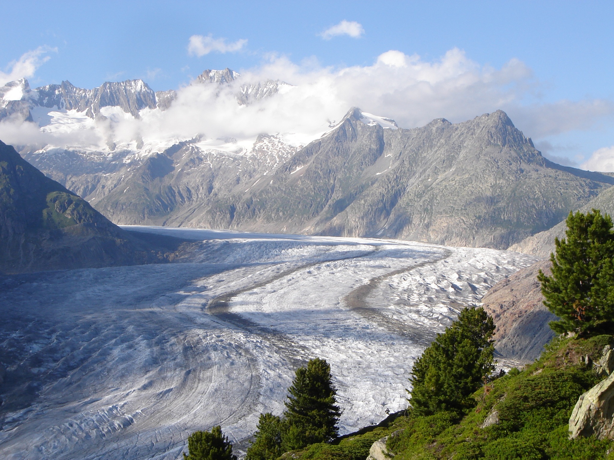
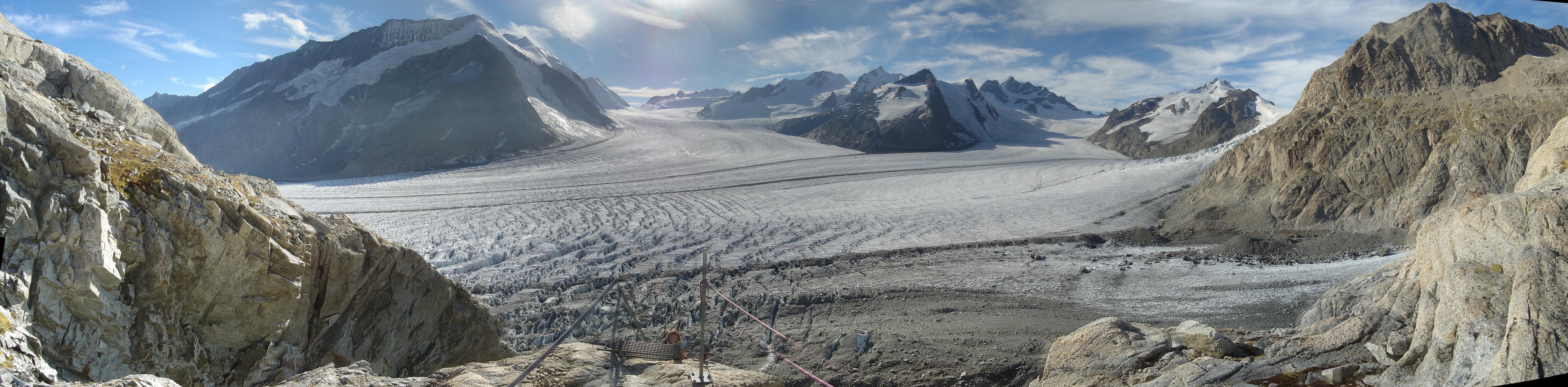
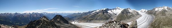 Aletsch Glacier from Eggishorn (Sept. 2007)
The great Aletsch Glacier shows considerable ice cover. At the Konkordiaplatz, it has an ice cover of more than 900 m, but as it moves to the south, the greater part of the ice melts, gradually decreasing the cover to around 150 m.
The characteristically dark medial moraine, situated almost in the middle of the glacier, runs protracted in two bands from the Konkordiaplatz along the whole length to the glacier's toe-zone. This medial moraine is collected from the ice of three large ice fields, which all run together. The westernmost medial moraine has been named the Kranzbergmoräne, and the easternmost carries the name Trugbergmoräne.
Formation and evolution
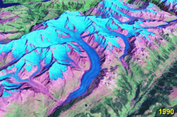 Slight retreat and some thinning can be seen between 1990 and 2000
The Aletsch Glacier resulted from the accumulation and compaction of snow. Glaciers generally form where snow and ice accumulation exceeds snow and ice melt. As the snow and ice thicken it reaches a point where it begins to move due to a combination of gravity and pressure of the overlying snow and ice.
During the last glacial periods, the Aletsch Glacier was much larger than now. 18,000 years ago the lower part of the ridge, between Riederalp and the glacier, was completely covered by ice. Only the summits of the Bettmerhorn, Eggishorn and the Fusshörner were above the glacier. After an important retreat, the glacier again advanced 11,000 years ago during the last glacial period. The glacier reached the Rhone valley, and its ice the Riederfurka. Remaining moraines are still visible in the Aletsch Forest.
Since the last glaciation, the glacier generally retreated. However slight climatic changes happened and, in 1860, the glacier was 3 km longer and the ice level 200 m higher.[3]
As for many other glaciers, records show a major longer-term retreat trend.[4][5]
On August 18th, 2007, photographer Spencer Tunick used hundreds of naked people in a "living sculpture" on the Aletsch Glacier in a photo shoot intended to draw attention to global warming and the shrinking of the world's glaciers. The temperature was about 10 °C (50 °F) at the time of the photo shoot. The 600 participants on the shrinking glacier volunteered for Tunick (a collaboration with Greenpeace) to let the world know about the effects of global warming on the melting Swiss glaciers.[6] The Aletsch Glacier receded by 100 m (330 ft) between 2005 and 2006.[7]
See also
References
- ^ Swiss Alps Jungfrau-Aletsch unesco.org
- ^ Villa Cassel pronatura.ch
- ^ Le Grand Glacier d’Aletsch pronatura.ch
- ^ Glaciology.ethz.ch
- ^ Aletschgletscher ethz.ch
- ^ Swissinfo: Volunteers strip off to fight climate change
- ^ Swissinfo: Experts size up glaciers as they melt away
Further reading
- Holzhauser, Hanspeter; Magny, Michel; Zumbuühl, Heinz J. (2005). "Glacier and lake-level variations in west-central Europe over the last 3500 years" (PDF). The Holocene 15 (6): 789–801. doi:10.1191/0959683605hl853ra. http://www.giub.unibe.ch/klimet/docs/climdyn_2005_Holzhauser_et_al.pdf.
External links
- Documentary film "Legacy of the Great Aletsch"
- Jungfrau-Aletsch-Bietschhorn official website
- Grosser Aletschgletscher on Glaciers online
- Panoramic drawing of area including hikes
Mountains Finsteraarhorn · Aletschhorn · Jungfrau · Mönch · Schreckhorn · Lauteraarhorn · Gross Fiescherhorn · Hinter Fiescherhorn · Grünhorn · Gletscherhorn · Eiger · Äbeni Flue · Bietschhorn · Gross Wannenhorn · Mittaghorn · Nesthorn · Wetterhorn · BlüemlisalpGlaciers North sideSouth sideLakes Categories:- Glaciers of Valais
- World Heritage Sites in Switzerland
- Visitor attractions in Switzerland
- Glaciers of the Alps


Wikimedia Foundation. 2010.