- Gemmi Pass
-
Gemmi Pass 
Gemmi PassElevation 2,314 m (7,592 ft) Traversed by Trail Location Location in Switzerland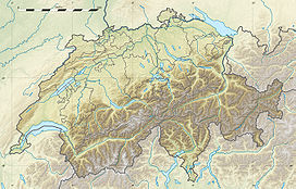

Location Valais,  Switzerland
Range Bernese Alps Coordinates 46°23′52″N 7°36′49″E / 46.39778°N 7.61361°ECoordinates: 46°23′52″N 7°36′49″E / 46.39778°N 7.61361°E Gemmi Pass (el. 2314 m.) is a high mountain pass across the Bernese Alps connecting Leukerbad (on the south) in the canton of Valais in Switzerland with Kandersteg (on the north) in the canton of Bern.
The pass lies between the Daubenhorn (2942 m.) in the west and the Rinderhorn (3448 m.) in the east.
The pass is at the west end of the Aar Massif and at the east end of the Wildstrubel Massif. Near the pass is the Daubensee, which has no outlet above ground.
The pass is mentioned in the Sherlock Holmes story The Final Problem. Sherlock Holmes and Dr. Watson cross the pass on their way to Meiringen, where Sherlock Holmes has his famous meeting with Professor Moriarty at the Reichenbach Falls.
The pass is described by Guy de Maupassant in his 1988 short-story Sur l'eau.
Although the pass cannot be traversed by road, it is still directly accessible by cablecar from Leukerbad. From Kandersteg a cable car gives access to the Sunnbüel area (1,934 m), 10 km north of the pass, allowing hikers to cross the pass on a wide and easy trail.
The pass itself is also used as a vantage point, because of the view of some major peaks in the Pennine Alps, such as the Dom, Matterhorn, Weisshorn and Dent Blanche.
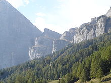 Gemmi Pass as seen from Leukerbad
See also
- List of highest paved roads in Europe
- List of mountain passes
External links
 Chisholm, Hugh, ed (1911). "Gemmi Pass". Encyclopædia Britannica (11th ed.). Cambridge University Press.Categories:
- Mountain passes of the Alps
- Mountain passes of Switzerland
- Bernese Oberland
- Mountain passes of Valais
- Valais geography stubs


Wikimedia Foundation. 2010.