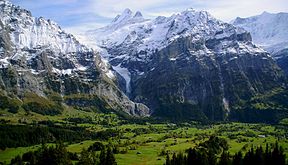
- Upper Grindelwald Glacier
-
Oberer Grindelwaldgletscher 
Oberer Grindelwaldgletscher (center)Location Canton of Berne, Switzerland Coordinates 46°37′8″N 8°50′40″E / 46.61889°N 8.84444°ECoordinates: 46°37′8″N 8°50′40″E / 46.61889°N 8.84444°E Length 6 km The Upper Grindelwald Glacier (German: Oberer Grindelwaldgletscher) is one of the two valley glaciers south of Grindelwald on the northern side of the Bernese Alps, in the Canton of Berne (the other being the Lower Grindelwald Glacier). It has a length of about 6 km (3.7 mi) and covers an area of nearly 10 km2 (3.9 sq mi).
The Upper Grindelwald Glacier arises from a vast snow field south of Schreckhorn and north of Wetterhorn. The glacier tongue is currently[when?] at around 1,400 metres (4,600 ft) above sea level, making it one of the lowest glaciers in the Alps.
External links
Mountains Finsteraarhorn · Aletschhorn · Jungfrau · Mönch · Schreckhorn · Lauteraarhorn · Gross Fiescherhorn · Hinter Fiescherhorn · Grünhorn · Gletscherhorn · Eiger · Äbeni Flue · Bietschhorn · Gross Wannenhorn · Mittaghorn · Nesthorn · Wetterhorn · BlüemlisalpGlaciers North sideSouth sideLakes Categories:- Glaciers of Switzerland
- Canton of Bern
- Glaciers of the Alps
- Canton of Bern geography stubs
Wikimedia Foundation. 2010.
