- Narberth railway station
-
Narberth 
Arberth 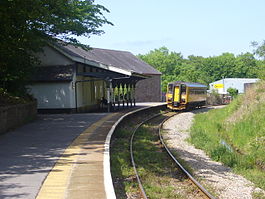
Location Place Narberth Local authority Pembrokeshire Coordinates 51°47′56″N 4°43′37″W / 51.799°N 4.727°WCoordinates: 51°47′56″N 4°43′37″W / 51.799°N 4.727°W Operations Station code NAR Managed by Arriva Trains Wales Number of platforms 1 Live arrivals/departures and station information
from National Rail EnquiriesAnnual rail passenger usage 2004/05 * 10,321 2005/06 *  11,140
2006/07 * 13,5562007/08 * 15,5472008/09 *  15,470
2009/10 * 15,974National Rail - UK railway stations A B C D E F G H I J K L M N O P Q R S T U V W X Y Z * Annual passenger usage based on sales of tickets in stated financial year(s) which end or originate at Narberth from Office of Rail Regulation statistics. Please note: methodology may vary year on year. Narberth railway station serves the town of Narberth, Pembrokeshire, Wales. The station is on the West Wales Line, 32 km (19¾ miles) west of Carmarthen.
Services
Monday to Saturdays, there is a two-hourly service westbound to Pembroke Dock and eastbound to Carmarthen and Swansea with fewer services in each direction on Sundays.
External links
- Train times and station information for Narberth railway station from National Rail
Preceding station  National Rail
Following station Whitland Arriva Trains Wales
West Wales LineKilgetty Transport in Pembrokeshire Road 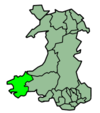
National Cycle Network Railway lines Railway stations Clarbeston Road · Clunderwen · Fishguard Harbour · Haverfordwest · Johnston · Kilgetty · Lamphey · Manorbier · Milford Haven · Narberth · Pembroke Dock · Pembroke · Penally · Saundersfoot · Tenby
Air Sea Categories:- Railway stations in Pembrokeshire
- Former Great Western Railway stations
- Railway stations opened in 1866
- Railway stations served by Arriva Trains Wales
- DfT Category F2 stations
- British railway request stops
- Wales railway station stubs


Wikimedia Foundation. 2010.