- Dryden (town), New York
-
Dryden — Town —  Location of Dryden in New York
 Dryden
Coordinates: 42°29′21″N 76°21′35″W / 42.48917°N 76.35972°WCoordinates: 42°29′21″N 76°21′35″W / 42.48917°N 76.35972°W Country United States State New York County Tompkins Website http://www.dryden.ny.us Dryden is a town in Tompkins County, New York, USA. The population was 13,532 at the 2000 census.[1] The town contains two villages: one also named Dryden and one named Freeville. The town is on the county's eastern border, east of Ithaca.
Contents
Geography
According to the United States Census Bureau, the town has a total area of 94.2 square miles (243.9 km²), of which, 93.9 square miles (243.1 km²) of it is land and 0.3 square miles (0.8 km²) of it (0.31%) is water.
The east town line is the border of Cortland County.
New York State Route 13 intersects New York State Route 38 at Dryden village. New York State Route 79 crosses the southwest part of the town, and New York State Route 366 crosses the northwest part and intersects NY-38 in Freeville. A small part of New York State Route 34B crosses the northwest corner of Dryden.
Cascadilla Creek flows out the west side of Dryden.
History
The region was part of the Central New York Military Tract used to pay soldiers of the American Revolution. It is named for John Dryden (1631–1700), the English poet and translator of Virgil (note this is the name of the town adjoining Dryden to the east). Dryden was also the translator of Plutarch's Lives which was probably used as a source for many of the names in the Military Tract by Robert Harpur in 1790.
The first settler arrived around 1797. The town of Dryden was established in 1803 from part of the town of Ulysses. In 1856, part of the town of Danby was added to Dryden.
In 2009, Dryden's Southworth Library sold an original manuscript of an Abraham Lincoln speech that had been delivered at the White House after his re-election. The document had been in the library's possession since 1926. It sold for $3.44 million dollars, a record-high selling price for an American historical document at an auction. [1]
Demographics
As of the census[1] of 2000, there were 13,532 people, 5,455 households, and 3,403 families residing in the town. The population density was 144.2 people per square mile (55.7/km²). There were 5,781 housing units at an average density of 61.6 per square mile (23.8/km²). The racial makeup of the town was 94.71% White, 1.49% Black or African American, 0.33% Native American, 1.48% Asian, 0.03% Pacific Islander, 0.58% from other races, and 1.38% from two or more races. Hispanic or Latino of any race were 1.65% of the population.
There were 5,455 households out of which 30.9% had children under the age of 18 living with them, 50.0% were married couples living together, 8.9% had a female householder with no husband present, and 37.6% were non-families. 27.5% of all households were made up of individuals and 6.3% had someone living alone who was 65 years of age or older. The average household size was 2.43 and the average family size was 2.98.
In the town the population was spread out with 25.5% under the age of 18, 10.0% from 18 to 24, 30.8% from 25 to 44, 24.6% from 45 to 64, and 9.2% who were 65 years of age or older. The median age was 35 years. For every 100 females there were 98.6 males. For every 100 females age 18 and over, there were 94.4 males.
The median income for a household in the town was $42,559, and the median income for a family was $54,886. Males had a median income of $37,579 versus $26,722 for females. The per capita income for the town was $22,415. About 7.3% of families and 12.0% of the population were below the poverty line, including 14.8% of those under age 18 and 6.0% of those age 65 or over.
Communities and locations in the Town of Dryden
- Bethel Grove – A hamlet on NY-79 in the southwest part of the town.
- Dryden – A village located on NY-13.
- Dryden Lake – A small lake near the east town line.
- Dryden Lake Wildlife Management Area – A conservation area by the east town line.
- Ellis (or "Ellis Hollow") – A hamlet in the southwest part of the town.
- Etna – A hamlet located near Ithaca.
- Freeville – A village located on NY-38.
- Hibbards Corners – A location in the western part of the town.
- Howland Corners – A location at the west town line on NY-34B.
- Lacy Corners – A hamlet north of Dryden village.
- Malloryville – A location in the northeast part of Dryden.
- Peruton – A location by the north town line.
- Red Mills – A hamlet northeast of Freeville.
- Smith Corners – A location at the west town line south of Howland Corners.
- Varna – A hamlet located near the west town line on NY-366.
- West Dryden – A hamlet in the northwest part of Dryden.
- Willow Glen – A location west of Dryden village on NY-13.
References
- ^ a b "American FactFinder". United States Census Bureau. http://factfinder.census.gov. Retrieved 2008-01-31.
External links
Municipalities and communities of Tompkins County, New York County seat: Ithaca City 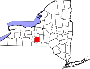
Towns Villages Cayuga Heights | Dryden | Freeville | Groton | Lansing | Trumansburg
CDPs Other
hamletsCategories:- Towns in New York
- Populated places in Tompkins County, New York


Wikimedia Foundation. 2010.