- Donington, Lincolnshire
-
Coordinates: 52°54′15″N 0°11′54″W / 52.904035°N 0.19824609°W
Donington 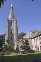
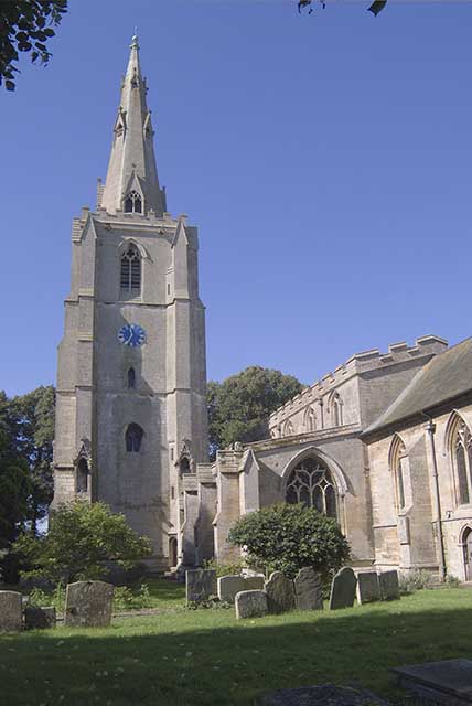
St Mary and the Holy Rood church, Donington
 Donington
Donington shown within LincolnshireOS grid reference TF 21280 35586 District South Holland Shire county Lincolnshire Region East Midlands Country England Sovereign state United Kingdom Post town Spalding Postcode district PE11 Police Lincolnshire Fire Lincolnshire Ambulance East Midlands EU Parliament East Midlands UK Parliament South Holland and The Deepings List of places: UK • England • Lincolnshire Donington is a village and civil parish in the South Holland district of Lincolnshire, England. It lies 8 miles (13 km) north of the market town of Spalding on the A152, and is bypassed by the A52. The parish includes the hamlet of Northorpe,[1] and falls within the drainage area of the Black Sluice Internal Drainage Board.[2] Donington is the birthplace of the explorer Matthew Flinders.
Donnington Grade I listed Anglican parish church is dedicated to St Mary and the Holy Rood.[3] The church is almost a complete combination of early Decorated and late Perpendicular style. Its chancel, however, is mainly Early English. The church tower and spire rise to 240 feet.[4]
Thomas Cowley School, parts of which are Grade II listed,[5][6] was founded by Thomas Cowley in 1701 to teach twenty poor children to read and write.[4] Explorer Matthew Flinders studied at the school (now called Thomas Cowley High School[7]) as did Lord (Donald) Bruce of Donington, a Labour peer who helped establish the NHS.
The village has three pubs: the Queen Inn, the Black Swan and the Black Bull. There is also a Coop in the Market Place.
Donnington has football teams for two age groups: Old Doningtonians for over sixteens, and Young Dons (established in 1996) for under sixteens; both play in the Saturday Boston League and the Mid-Lincolnshire Junior League.
References
- ^ "Northorpe hamlet". GENUKI. GENUKI. http://www.genuki.org.uk/big/eng/LIN/Donington/. Retrieved 2 August 2011.
- ^ "The Black Sluice Internal Drainage Board". http://www.blacksluiceidb.gov.uk/.
- ^ "Church of St Mary and the Holy Rood", National Heritage List for England, English Heritage. Retrieved 21 July 2011
- ^ a b Cox, J. Charles (1916) Lincolnshire pp. 117, 118; Methuen & Co. Ltd
- ^ "Old School Building at Cowleys School", National Heritage List for England, English Heritage. Retrieved 21 July 2011
- ^ "North Wing of Cowleys School", National Heritage List for England, English Heritage. Retrieved 21 July 2011
- ^ Thomas Cowley High School
External links
- "St Mary and the Holy Rood", Churches in England. Retrieved 21 July 2011
- "Donington", genuki.org.uk. Retrieved 21 July 2011
Categories:- Villages in Lincolnshire
- Civil parishes in Lincolnshire
- Lincolnshire geography stubs

Wikimedia Foundation. 2010.