- New Jersey Route 82
-
Route 82
Morris Avenue
Jewish War Veterans Memorial HighwayRoute information Maintained by NJDOT Length: 4.92 mi[1] (7.92 km) Major junctions West end: 
 Route 124 / CR 577 in Springfield Township
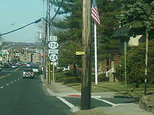
 US 22 / G.S. Pkwy. in Union Township
East end:  Route 439 in Union
Highway system New Jersey State Highway Routes
Interstate and US←  Route 81
Route 83  →
→Route 82 is a short, state highway in Union County of the U.S. state of New Jersey. It runs southeast from an intersection with Route 124 in Springfield Township along Morris Avenue to Route 439 in the Elizabeth general area. Along the 4.92 miles (7.92 km) route, it serves local businesses and the main arterial of Union Township. Near its eastern terminus at Route 439, Route 82 passes through Kean University, a state college in New Jersey. Route 82 originates as of one two Route S24 alignments designated in the 1927 state highway renumbering. A spur of Route 24, it lasted for 26 years untouched until the 1953 state highway renumbering, when Union County's Route S-24 was designated as Route 82 and a portion of Route 439. The route's alignment has changed little since the 1953 renumbering.
Contents
Route description
Route 82 begins at a traffic light complex with New Jersey Route 124 eastbound and County Route 577 eastbound in the community of Springfield, New Jersey. The highway progresses southward along Morris Avenue through a large business district. A short distance after, Route 82 intersects with Maple Street, which serves Route 124 westbound and the community of Maplewood. The route continues southward along Morris, heading through the business district of Springfield. Residential homes begin to pop around the southbound direction before the highway crosses over the Rahway River. From there, Route 82 enters Union, where it enters a large commercial district once again. During the highway's progression southward, Route 82 enters more residential regions, intersecting with Liberty Road in the northern end of the community. Liberty Road connects Route 82 with U.S. Route 22 in Hillside. The highway continues southward along Morris Avenue, entering further into Union, where it serves as the main road to the community. At a fork with Elmwood Avenue, Route 82 diverts to the east along Morris, leaving the northern portion of Union.[2]
Route 82 continues eastward as the main arterial, passing between many residential homes in both directions. The highway then enters the center of Union Township, where it intersects with Union County Route 619 (Stuyvesant Avenue) and to the north of Friberger Park. Morris Avenue continues through a largely residential and commercial district in Union before crossing under the westbound lanes of U.S. Route 22 and the eight lanes of the Garden State Parkway and Exits 139B (northbound only), 140 (both directions) and 140A (southbound only). Route 82 then passes under the eastbound lanes of U.S. Route 22 before continuing along Morris into Union Township. A short distance later, the route approaches an at-grade cloverleaf interchange with a shopping mall access road before passing to the north of the local golf club, Suburban Golf. Route 82 and Morris Avenue continue southward, passing through the middle of residential homes as a four-lane boulevard. A short distance after the golf club, the highway intersects with County Route 509 (Salem Avenue). From there, Route 82 becomes a divided arterial, passing to the south of Elizabeth River Park and crossing under the Raritan Valley Line maintained by New Jersey Transit. The nearby intersection for Green Lane serves the nearby Union Station along the rail line. After the intersection with Green Lane, Route 82 enters the area of Kean University, which surrounds the highway in both directions. After intersecting with the university's access roads, Route 82 crosses through small patches of trees before terminating at an intersection with New Jersey Route 439 (North Avenue). Morris Avenue continues eastward as Union County Route 629.[2]
History
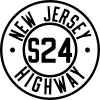 Route S24 (1927-1953)
The alignment along Morris Avenue through Union and Springfield was originally the alignment of State Highway Route S-24, a prefixed spur of State Highway Route 24. This was one of two State Highway Route S-24s designated in the 1927 state highway renumbering, with the other out in Warren County. Route S-24 in Union County was designated to run from Route 24 in Springfield (now Route 124) along Morris Avenue to an intersection with Route 25 in Elizabeth. (The alignment of Route 25 is now U.S. Routes 1 and 9.) At the intersection with current-day Route 439, Route S-24 turned off of current-day Route 82 and onto Route 439 southbound towards the Goethals Bridge across the Arthur Kill.[3] Although the route remained intact for twenty-six years, the 1953 state highway renumbering occurred on January 1, and Route S-24 was re-designated as Route 82 and Route 439, while Route 24 through Springifeld remained the same.[4] The route's general alignment has remained virtually unchanged since the 1953 renumbering, with the highway remaining on Morris Avenue.[5] In 2005, the New Jersey Department of Transportation was given $800,000 USD in an earmark to give Route 82 roadway and intersection improvements.[6]
Major intersections
The entire route is in Union County.
Location Mile[1] Destinations Notes Springfield Township 0.00 Route 124 (Springfield Avenue) / CR 577 north (Main Street)Western terminus of NJ 82. Union Township 2.64 US 22Interchange 2.68 G.S. Pkwy.Exits 139B, 140, & 140A (GSP) 3.83  CR 509 (Salem Road)
4.92 Route 439 (North Avenue)Eastern terminus of NJ 82. 1.000 mi = 1.609 km; 1.000 km = 0.621 mi See also
 U.S. Roads portal
 New Jersey portal
References
- ^ a b New Jersey Route 82 straight line diagram from New Jersey Department of Transportation
- ^ a b Bing Maps/Microsoft Inc. (2009). Overview map of Route 82 (Map). Cartography by NAVTEQ Inc.. http://www.maps.bing.com/maps/?FORM=Z9LH8#JmNwPTQwLjY5MzM2NDA2ODg2NTc3Nn4tNzQuMjY3NzQzNzUxNDA2NjcmbHZsPTEzJnN0eT1yJnJ0cD1wb3MuNDAuNzEwNDY3ODQ1MjAxNDlfLTc0LjMwODAzNzkwNjg4NTE0X25lYXIlMjAxNTQlMjBNb3JyaXMlMjBBdmUlMkMlMjBTcHJpbmdmaWVsZCUyQyUyME5ldyUyMEplcnNleSUyMDA3MDgxJTJDJTIwVW5pdGVkJTIwU3RhdGVzX19fYV9+cG9zLjQwLjY3NjI2MDI5MjUzMDA2Xy03NC4yMjc0NDk1OTU5MjgxOV9fX19hXyZydG9wPTB+MH4wfg==. Retrieved 17 December 2009.
- ^ ROUTE No. S-24. From Stephensburg to Hackettstown, connecting Route No. 24 with Route No. 6, and spur from Springfield along Morris Avenue to Route No. 25 at Elizabeth. L. 1927, c. 319.
- ^ 1953 renumbering, New Jersey Department of Highways, http://en.wikisource.org/wiki/1953_New_Jersey_state_highway_renumbering, retrieved July 31, 2009
- ^ New Jersey Department of Transportation (2007). New Jersey Official Road Map (Map). Cartography by New Jersey Department of Transportation.
- ^ "Roadway and intersection modifications on New Jersey Route 82.". Washington D.C.: United States Department of Transportation. 2005. http://earmarks.omb.gov/authorization_earmarks/earmark_186353.html. Retrieved 17 December 2009.
External links
Categories:- State highways in New Jersey
- Transportation in Union County, New Jersey


Wikimedia Foundation. 2010.